2006:1041 - ISLANDS (Site AR46), Kilkenny
County: Kilkenny
Site name: ISLANDS (Site AR46)
Sites and Monuments Record No.: N/A
Licence number: E002388
Author: Colum Hardy, for Valerie J. Keeley Ltd.
Author/Organisation Address: Brehon House, Kilkenny Road, Castlecomer, Co. Kilkenny
Site type: Burnt mound and Field system
Period/Dating: Multi-period
ITM: E 628423m, N 665161m
Latitude, Longitude (decimal degrees): 52.736788, -7.579115
An excavation was carried out in September and October 2006 in advance of the construction of the M8/N8 Cullahill to Cashel road improvement scheme. Prior assessment and centreline test-trenching was carried out in 2005 by Colm Moriarty (Excavations 2005, No. 790, see A027/014). This site was located north of Urlingford, c. 50m west of the River Goul. Excavation identified two large shallow burnt mounds.
The easternmost mound measured 7m north–south by 5m and 0.35m in depth. It was composed of a medium compacted black sandy silt with frequent charcoal and burnt stone. Beneath this was a regular-shaped circular cut with varying sides and a flat regular base, 1.86m north–south by 1.84m and 0.4m in depth, that contained two fills and seven badly deteriorated timbers (possibly planks). The timbers were 0.08–0.96m in length and were orientated north-north-west/south-south-east, except for one small piece that was orientated east–west.
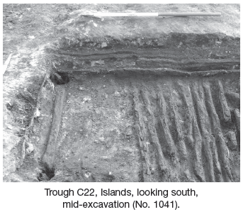
The western mound measured 12.05m north–south by 8.65m and 0.14m in depth and was composed of a black moderately compact sandy silt with frequent burnt stone and charcoal. Underneath this mound was a very regular rectangular trough measuring 1.7m by 1.4m and 0.24m in depth. It had a flat base and vertical sides and was filled by a black mix of charcoal, burnt stone and sandy silt. Approximately twenty timbers were identified within the base of the cut around its perimeter and covering two-thirds of the base, the longest one measuring 1.43m. Within each of the corners of the cut were post-holes. They were circular in shape and had depths of 0.23–0.31m, with the remnants of timber posts still in situ. Positioned in close proximity to three of these post-holes were a number of smaller stake-holes angled towards the main corner post, indicating that they probably acted as some sort of support. Located just to the west adjacent to the trough was an oval feature defined by a series of small stake-holes (c. 14), some with wooden fragments still in situ. Located to the west of the rectangular trough and the oval staked feature was a rounded cut measuring 2m by 0.8m and 0.21m in depth. Five pieces of timber were identified, the largest measuring 1m in length. One timber appears to have been worked.
A series of later plough furrows and field ditches were also recorded across the site, as well as a large substantial field boundary that divided the northern and southern area, with a width of 2.1m at the base and narrowed to 1.1m at the top.