2006:1019 - EARLSRATH, Kilkenny
County: Kilkenny
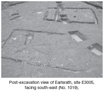
Site name: EARLSRATH
Sites and Monuments Record No.: N/A
Licence number: E003005
Author: Liam Mckinstry, for Valerie J. Keeley Ltd.
Author/Organisation Address: 9 Ballantyne Place, Steamboat Quay, Limerick, Co. Limerick
Site type: House - prehistoric
Period/Dating: Prehistoric (12700 BC-AD 400)
ITM: E 656353m, N 625749m
Latitude, Longitude (decimal degrees): 52.380400, -7.172269
The excavations at Earlsrath, sites E2510, E3005, E3006 and E3007, were undertaken as part of the archaeological programme for the N9/N10 Waterford to Powerstown road scheme.
Site E3005 consisted of two large rectangular structures, which were cut by a large V-shaped boundary ditch. The boundary ditch started out from the western part of the site and curved down towards the south-east corner, cutting through Structures 1 and 2. The overall length of the ditch was 31.5m. The ditch had a concave base. The maximum width was 2.25m and the minimum was 1.5m. The maximum depth was 1.3m and the minimum was 1m. The full extent of the ditch is unknown, but a number of test-trenches excavated to the south-east of the site suggested it continued with a slight curve for c. 70m.
Structure 1 was rectangular and consisted of a large foundation trench into which a number of post-holes had been cut. The structure was c. 11.5m by 7.8m and had a north-east/south-west orientation. An internal foundation trench divided off the north-eastern part of the structure, forming two separate rooms. In the north-eastern side there was an opening that may have served as an entrance. The depth of the structure ranged from 0.2m to 0.53m, except in the north-west side, which was significantly deeper than the other sides, with a maximum depth of 0.78m and a minimum of 0.61m. There were also a number of large post-holes located throughout the foundation trenches and in each of the corners of the structure. Two post-holes were located on either side of the entranceway and a further two were located within the interior.
Structure 2 was also rectangular and consisted of shallow foundation trenches with a maximum depth of 0.3m. The structure was c. 13.1m by 7m and had a north-east/south-west orientation. Structure 2 was parallel to Structure 1 and c. 4m to the north-west of it. Within the interior of the house were several linked linear features, which were possibly internal features or divisions within the structure.
The dates of both structures were difficult to ascertain, as only a few artefacts were recovered from the bottom fills and all of these were of a prehistoric date; e.g. the polished stone axe recovered from the base of Structure 1. A number of post-medieval artefacts were recovered from the site but were either surface finds or from the upper fills of Structure 2 and the V-shaped ditch. No modern finds were recovered from the lower, more secure, fills of the structures, so it is possible that they were of a prehistoric date, though this will only be confirmed after 14C dating results are received.