2006:842 - TREANBAUN, Galway
County: Galway
Site name: TREANBAUN
Sites and Monuments Record No.: N/A
Licence number: A024/27, E2123
Author: Marta Muñiz Pérez for CRDS Ltd.
Author/Organisation Address: Unit 4, Dundrum Business Park, Dundrum, Dublin 14
Site type: Burial ground, Souterrain and Cist
Period/Dating: Multi-period
ITM: E 569093m, N 726198m
Latitude, Longitude (decimal degrees): 53.285201, -8.463492
This excavation was undertaken as part of the archaeological investigations carried out on the route of the proposed N6 Galway to Ballinasloe road scheme. The site was identified through linear testing in October 2005. Excavation works were carried out between April and August 2006. Work was commissioned by Galway County Council and the National Roads Design Office and sponsored by the National Roads Authority.
The site is located on a low hill, part of a glacial esker running north-east/south-west. The site was divided into two areas: Area A was located to the east, on the summit of the hill; Area B was to the west, on a gentle slope. The archaeological remains in both areas had suffered heavy truncation due to agricultural practices.
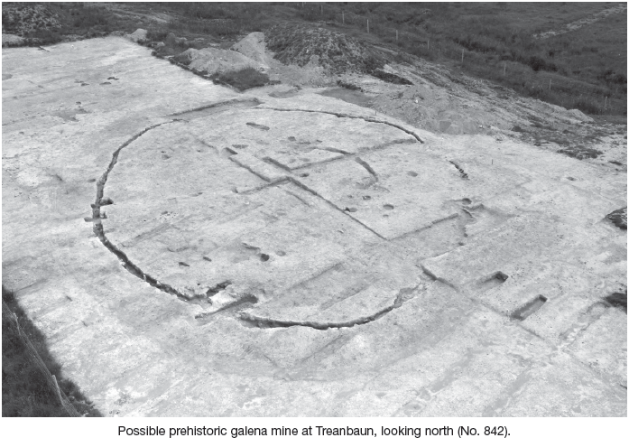
Area A revealed the existence of a subcircular ditch, as well as the remains of a possible souterrain and a burial-ground. Area B yielded the remains of two Bronze Age cremation cists and some possible settlement remains also related to the Bronze Age, as well as a large pit excavated through natural bedrock that has been interpreted as a possible lead mine.
Area A
The ditch in Area A measured c. 70m in diameter. Up to 90% of the feature was included in the footprint of the development. The ditch was more substantial towards the east and north-east, where it reached up to 1.4m deep and 1.2m wide. The only entrances found were located to the south-east and south-west. The entrance to the south-east consisted of a narrow non-excavated area lined with a kerb to the west. To the south-west, the ditch had been partially backfilled with soil and stone in order to create a second narrow entrance. A certain amount of animal bone was recovered from the fills of the ditch, including cattle and dog, as well as some finds of a domestic nature such as a loom weight and a spindle whorl. No features were recognised in the enclosed area which would suggest a settlement, except for two burnt pits whose function is difficult to ascertain. The main concentration of archaeological remains was located in the southern quadrant of the enclosed area. One cremation pit was uncovered, surrounded by the very faded remains of a possible barrow ditch. In the same area, the skeletal remains of up to 31 individuals were also uncovered. Most of the skeletons were oriented west–east, with the exception of two north–south-orientated burials. No finds were recovered associated with the skeletons.
Also within the eastern area, the remains of a possible beehive-type souterrain were located. This consisted of a narrow single corridor aligned along the outer edge of the enclosing ditch for 5m, turning there towards the east in an obtuse angle for a further 3m and opening to a circular chamber of c. 4.5m diameter. The souterrain had been heavily robbed out. Revetment of the walls only survived in part of the corridor. Stratigraphy suggested that the ditch and souterrain were filled at the same time. One green glass bead was recovered from the fills of this feature.
A number of large circular pits were located in the area, truncating the ditch. These were pits excavated for gravel extraction, probably of modern date.
Finds recovered from cleaning back and without a clear context include a polished stone axe and a blue glass bead.
Area B
An inverted urn with cremation in a roughly stone-lined cist was excavated. The cist did not present a stone cap and the top of the feature was heavily disturbed. The urn was broken except for the rim, which was intact and presented incised decoration in shape of triangles.
This feature was partially truncated by a large circular pit, c. 7m diameter and 2.2m deep. This pit was excavated through natural bedrock (limestone). Two groups of fills were distinguished: the upper fills, with more organic and charcoal content, and the lower fills, where stone and inorganic matter was more common. In the interface between these two groups, reddened clay and a cremation in a cist were located. A heavily burned flint knife was found in the cremation. The cut of the large pit was reddened, possibly by fire action. A metallic mineral, possibly galena, was visible in the bedrock.
Not physically associated with these features, to the south-east extent of the area, a series of pits, gullies and possible post- and stake-holes were identified. Unfortunately, it was not possible to distinguish any shape that could suggest the existence of structures. Very burnt Bronze Age pottery was recovered from one of the pits. Other finds include a small quantity of chert debitage remains.
Two more gravel extraction pits were identified in this area.
Conclusion
The site at Treanbaun was a multi-period site. The oldest features can be dated to the Bronze Age, such as most features in Area B, including the two cists with cremations and the group of pits and post-holes. The large circular pit can be also dated to the Bronze Age. It is suggested that this pit was excavated in order to extract the galena included in the bedrock, the rock being broken with the aid of fire and tools made of bone and/or wood. Simple bonfires would reach a high enough temperature to extract the lead contained in the galena, thus not leaving unequivocal archaeological remains. Analysis and research is being carried out in order to confirm this hypothesis.
The cremation pit and possible barrow may also be of prehistoric date. Results of radiocarbon dating are expected to clarify the chronological sequence of the site.
The site was reused during early medieval times. A large enclosure ditch was excavated surrounding the hill where a prehistoric barrow was located, and in the enclosed space a burial-ground was established. Although no clear settlement remains were found during excavation, it is possible that the site was also used for domestic purposes, as suggested by the nature of the finds recovered from the ditch. The souterrain was associated with the ditch, as it was possibly excavated through the bank and there is no evidence of truncation between the two features.
Possibly in modern times, the hill where the site is located was exploited for gravel and stone extraction. The souterrain was robbed out and the stones of best quality selected and carried away. Large circular pits were excavated scattered over the area in order to extract gravel, which could be used in construction in the vicinity.
Finally, agricultural activity produced heavy truncation on the existing archaeological remains.
Excavation works in Treanbaun are now finished and reporting and specialist analysis are currently being carried out.