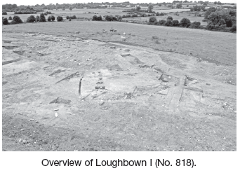
County: Galway Site name: LOUGHBOWN I
Sites and Monuments Record No.: GA087–178 Licence number: E002442
Author: Nik Bower, Eachtra Archaeological Projects
Site type: Ringfort - rath and Souterrain
Period/Dating: Early Medieval (AD 400-AD 1099)
ITM: E 581640m, N 729277m
Latitude, Longitude (decimal degrees): 53.313448, -8.275506
This was one of several excavations undertaken for Galway County Council and the National Roads Authority which form part of a wider excavation programme undertaken within c. 15 km of the proposed N6 Galway to Ballinasloe dual carriageway scheme (Contract 4). The enclosure measures 60m in diameter north–south by 30m. Half of the ringfort was excavated, as the northern half of the monument is located outside the limits of the CPO. The site is situated in a classic position for a ringfort. It is below the brow of a hill, affording good drainage and the maximum view available across the valley to the north, north-west, north-east and east.
The external ringfort ditch cut a linear feature at the eastern end of the site. This feature could be prehistoric in date or it may simply relate to a field system that immediately pre-dated the ringfort.
The inner ditch is U-shaped in profile with a flat bottom. It slopes downhill, following the contours of the site, and is c. 3m wide by 1.1m deep by 42m in diameter. The ditch termini are located to the south-east, as is common in ringforts. There is evidence of at least two recuts in the ditch, suggesting it has been maintained over a period of time.
An inhumation was found in the base of the western terminus, orientated with the head to the west. Three large stones were recorded against the ditch cut around the body at cardinal points, north, east and south.
The outer ditch is less substantial than the inner ditch, with a V-shaped profile (1.5m width by 0.8m depth and 63m diameter) and sloping downhill, from west to east. The associated bank, made up predominately of orange sandy silt, was substantial. This bank was clearly evident upon stripping. Two parallel slot-trenches, entranceway post-holes and a V-shaped gully were located in the area of the entrance.
The interior of the enclosure appears to have had a layer of orange silt subsoil removed, to expose a well-draining gravelly boulder clay underneath. This may have helped level the interior of the site without hindering drainage. This scarping of the site and production of a large volume of spoil may have contributed towards the construction of a substantial internal bank, reducing the necessity for a large ditch and therefore reducing the labour involved.
Post-holes and some small pits were dispersed through the interior. Next to the causeway inside the inner bank three substantial, stone-packed post-holes suggest an internal gate. An area of intense burning found to the east of the souterrain may be related to crop-processing activities.
The souterrain was only partially uncovered, as it was located on the edge of the excavated area. The relationship between the souterrain and the enclosing ditches is not yet clear, but it seems possible that the inner bank to the west may have been related to the construction of the souterrain. The souterrain is orientated north–south, constructed from limestone blocks, and was roofed with large limestone slabs, which have since collapsed and possibly been removed. It measures 1.56m wide, by 1.25m deep by 7.16m long and continues into the baulk, with a creep-hole or vent orientated west to east running from its eastern side. There is a possible second chamber beyond the excavated area that runs parallel to the first.
Ironworking took place in the lower eastern area of the site, subsequent to disuse/backfilling of the enclosing ditches. An area of the site, generally outside the inner enclosure ditch, appears to have been walled off; a large pit, a possible cistern and a gulley constructed to drain water into the cistern were built. The walls may have been used to contain the debris produced during the ironworking process. Three small bowl furnaces were found in this area.
Post-medieval building foundations, built with limestone blocks and mortar, were recorded at the western edge of the enclosure. These were repaired at a later date with cement and yellow brick and may have been used as outbuildings. They are L-shaped in plan and match the buildings represented on the first-edition OS map of 1838. The least disturbed and possibly the earliest of these buildings has a rotary quernstone (Galway/Connemara granite), chased and reused as part of its wall, suggesting that the builders reused building materials available from the ringfort. These buildings are known locally as ‘the forge’, though there is little evidence as yet of this. The enclosing property boundary respects the inner enclosure ditch. Peat is evident in quantity lying across the top of the inner ditch and against the internal bank at the western end of the site, perhaps the remains of a peat reek relating to the 19th-century buildings.
Local landowners told of land improvements made during the 1960s on this site. This purportedly involved the removal of a ring of beech trees encircling the extant hawthorn tree and levelling of the field to some degree.

Ballycurreen Industrial Estate, Kinsale Road, Cork