County: Galway Site name: KILLESCRAGH
Sites and Monuments Record No.: N/A Licence number: A024/23, E2071
Author: Ken Curran, for CRDS Ltd.
Site type: Structure, Burnt mound, Platform and Hearth
Period/Dating: Multi-period
ITM: E 562573m, N 724946m
Latitude, Longitude (decimal degrees): 53.273524, -8.561112
Sheelagh Conran carried out testing in the townland of Killescragh for the route of the N6 Galway to East Ballinasloe road scheme. During this testing a burnt mound was identified at Killescragh (Excavations 2005, No. 617, A024/3.30). An area of c. 500m was initially recommended for further investigation. Subsequent excavations revealed associated wooden features, both connected to the mound and within the area surrounding it. As a result, an area of c. 5000m was tested extensively in order to confirm or deny the presence of any other wooden structures. Following this testing, an area of c. 1000m was found to contain archaeological deposits. These were all clustered around the original burnt mound as discovered by Sheelagh Conran. The site was excavated in May–July 2006. Work was commissioned by Galway County Council and the National Roads Design Office and sponsored by the National Roads Authority.
This burnt mound has been interpreted as a two-phase fulacht fiadh with a trough, stake cluster and burnt mound associated with Phase 1 and a woodworking area, track, platform structure and hearth associated with Phase 2. All the main features and archaeological contexts are believed to have been constructed or deposited after a substantial waterborne inundation of the area of unknown origin. During excavation sufficient sampling was undertaken to allow a detailed environmental report to be written, which will eventually complement the excavation record. Part of this environmental report will be a reconstruction of the environment around the site at the time it was created. The retention of all worked wood found during excavation will facilitate a detailed analysis of the tools and methods used to construct the various features on the site, as well as to give a period in which to set it. Animal bone was prevalent lying above, within and directly below all burnt material associated with the fulacht, indicative of a function connected to the cooking of animal meat.
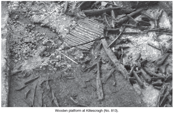
Individual features identified included: a stake cluster, a trough/platform, a burnt mound (with two phases), a wooden platform and a hearth and a black spread.
Associated with the main features were a number of secondary features. A woodworking area lay at the north-eastern limits of the site and it was linked to the platform by a possible trackway/saddle surface that ran over the mound from east to west. This track joined the substructural elements of the platform to form a wooden substructure of overlapping woods and timbers, up to three layers deep. One part of this substructure may (in addition to supporting the platform) have incorporated a single plank causeway leading to the platform from the north. The largest volume of burnt material deposited on the site was associated with the first phase of the fulacht and no second trough could clearly be associated with the subsequent phase. The area around the platform (associated with Phase 2) was heavily disturbed and it may be that a simple pit dug into the earlier mound was sufficient as a trough during Phase 2.
The burnt mound/fulacht fiadh has been provisionally dated to the late Bronze Age/early Iron Age, depending on results from the 14C and other dating currently being processed.

Unit 4, Dundrum Business Park, Dundrum, Dublin 14