County: Galway Site name: GORTNAHOON
Sites and Monuments Record No.: N/A Licence number: A024/28, E2075
Author: Tamás Peterváry, for CRDS Ltd.
Site type: Industrial site
Period/Dating: Early Medieval (AD 400-AD 1099)
ITM: E 571906m, N 725768m
Latitude, Longitude (decimal degrees): 53.281494, -8.421264
The excavation in Gortnahoon was part of the archaeological investigations associated with the proposed N6 Galway to Ballinasloe road scheme. The site was detected during test-trenching and was excavated during June/July 2006. Work was commissioned by Galway County Council and the National Roads Design Office and sponsored by the National Roads Authority.
The excavation took place in four areas located at a distance of c. 30m from one another along the route of the proposed road. A number, increasing from east to west, was assigned to each area.
As radiocarbon dates are not yet available, the site was dated upon structural and artefactual evidence, which points to the later phase of the early historic period. The separate excavation areas appeared to represent one single phase of activity. Three areas contained features of industrial purpose, among which kilns—one per area—played an important role. Two of these kilns were encircled by curvilinear enclosing elements and one kiln—a partially enclosed example—was found in spatial association with three semi-sunken structures and a rather elusive metalworking area marked by curvilinear trenches, ditch segments and a great amount of iron slag.
Area 1 revealed a keyhole-shaped kiln, a post-hole and an irregular water pit. The kiln had a north-east/south-west orientation and consisted of a bowl-shaped sub-oval drying chamber (1.05m by 0.75m by 0.12m deep) and a truncated narrow flue (1.12m by 0.25m by 0.08m deep), the width of which slightly narrowed towards the drying chamber. Three sherds of pottery, the base fragments of a vessel, were recovered from the fill of the flue.
Area 2 revealed an enclosed dumbbell-shaped kiln and three unevenly scattered stake-holes, a post-hole and four pits around the enclosed area. The east–west-orientated kiln (2.5m by 1m by 0.2m deep) represented the only feature within the penannular, shallow (maximum 0.3m deep) enclosure trench. The kiln was stone-lined and contained a deposit of peat ash. The curvilinear trench, which had an east-facing entrance, had on two occasions been reconstructed.
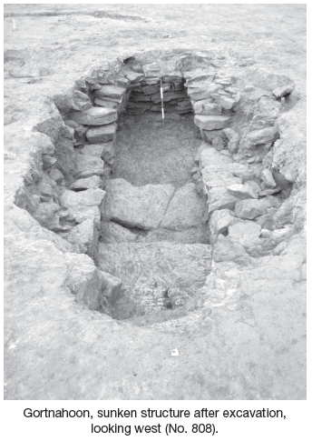
Area 3 revealed a partially enclosed L-shaped kiln, three semi-sunken stone structures, a possible furnace and an area defined by curvilinear trenches and post-holes. The 6.5m-long stone-lined kiln had a north/south orientation and its two chambers were connected by a 2.8m-long flue, the width of which slightly tapered towards the drying chamber to the north. A copper-alloy stick pin was recovered from the fill of the flue. The enclosing elements around the kiln consisted of two shallow, curvilinear trench segments (maximum. 0.1m deep). The enclosure (c. 9m in diameter) had a wide opening to the south.
Its northern extent was defined by Structure B, one of the three semi-sunken stone structures cut into the natural bedrock. This structure had an elongated sub-oval shape with an east–west orientation (6.8m by 3.5m by maximum 1.5m deep) and its base descended to the west. A two-sided, composite bone comb and charred cereal remains were recovered from the primary fill of this structure.
Structure A, located to the north of structure B, was D-shaped in plan (4.5m by 3.4m by maximum 1m deep). Both structures had an entrance to the east, where the limestone bedrock was cut to form descending steps leading into the interior. A pit in front of the entrance of Structure A contained a deliberately deposited fragmentary rotary quern.
Structure C, located to the south-east of Structure B, was sub-oval in plan (4.3m by 2.9m by maximum 0.9m deep). The bedrock-cut base descended towards the south-east. The structure had a north-facing entrance. The remains of a dismantled small furnace were located between Structure B and Structure C. This was a shallow subrectangular feature (1.85m by 1.75m by 0.21m deep), which contained pieces of slag and vitrified clay and had a rectangular projection to the north. The area to the east accommodated two curvilinear and one straight segment of shallow trenches (maximum 0.2m deep) which contained lumps of slag, among which pieces of tap-slag were identified. One of these trenches, together with six post-holes, formed a semicircular pattern, suggesting the former presence of a structure here. A 3.93m-long east–west trench ran from the middle of this structure, where it was flanked by two intercutting ditches towards the west.
Area 4 revealed a pit, the upper fill of which contained calcined bone fragments.
The excavation in Gortnahoon revealed parts of the industrial quarter of a settlement with a capacity to cater for local demands. Although the economical aspect of the site is of local importance, the excavated features, such as the stone-lined semi-sunken structures, show that the craftsmen in Gortnahoon took an active part in the wider network of exchange of technological and structural ideas of the time.

Unit 4, Dundrum Business Park, Dundrum, Dublin 14