2006:786 - DEERPARK, Galway
County: Galway
Site name: DEERPARK
Sites and Monuments Record No.: N/A
Licence number: A024/18, E2057
Author: Tom Janes, Headland Archaeology Ltd.
Author/Organisation Address: Unit 1, Wallingstown Business Park, Little Island, Co. Cork
Site type: House - 18th/19th century
Period/Dating: Modern (AD 1750-AD 2000)
ITM: E 553375m, N 725133m
Latitude, Longitude (decimal degrees): 53.274475, -8.699044
Excavation work was carried out on behalf of Galway County Council as part of Contract 2 archaeological investigations prior to the commencement of construction of the N6 Galway to Ballinasloe scheme. The project is funded by the Irish government and the European Union under the National Development Plan 2000–2006.
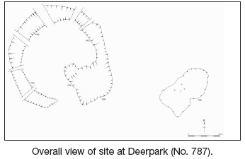
Site A024/18 was located c. 3.8km south-east of Athenry. The land comprised undulating farmland. Full archaeological resolution was conducted on this site between 24 April and 26 May 2006. Excavation revealed that the site was comprised of a cobbled yard defined by a wall on the northern, eastern and southern sides. No evidence for a wall was found to the west, where the steeply rising glacial till would perhaps have made its construction unnecessary. Leading into the yard was a north–south-orientated cobbled causeway, which could clearly be seen on the surface running beyond the limit of excavation to the south. Within the courtyard were at least two structures of substantial size, and two smaller structures which may have served as storage areas. A probable well, though located outside the boundaries of the wall, may have been contemporary with the site.
Artefacts recovered from the site suggest a post-medieval date for the features: fragments of clay pipe, glazed pottery and metal objects including a copper coin dating to 1853. A large quantity of animal bone was also recovered.
The largest feature on site was a cobbled yard surface measuring c. 26m north–south by 22m. Four distinct areas within this yard were defined by different sizes and patterns of cobbles. A number of refuse pits were identified beneath the cobbles; animal bone, shellfish and fragments of post-medieval glazed pottery were recovered from the fills. Although its eastern surface had been truncated by modern activity, the extent of the yard was clearly defined by the course of a stone wall.
The eastern wall was an average of 1m wide and was set into a narrow foundation trench cut into the glacial till. It was constructed of roughly hewn limestone. The wall survived to a height of two courses, with both courses set into this trench to a depth of 0.6m. At the northern extent, the wall measured 6m east–west by 8.5m. After a 5m gap the wall continued south for another 8.5m. On the northern side of this gap was a second wall, abutting the first and continuing east for 5m.
In the north-east corner the wall truncated the eastern extent of a small structure measuring 4.5m east–west by 3m. The extent of this structure was defined by a low stone wall, and the remains of a plaster floor surface were noted within.
A stone-filled pit measuring 13m east–west by 5m was identified beneath the southern section of the eastern wall. Several samples of animal bone were recovered from this feature, which is likely to be a backfilled quarry pit.
The wall on the southern edge of the yard surface was of similar construction to the other walls, although it was not set into a foundation trench. It survived in places to two courses and measured a total of 31m east–west including a gap 7m wide midway along its length. Through this gap a cobbled surface extended c. 10m south beyond the wall. This probable road was bordered on both sides by shallow drainage ditches filled with fine-grained silt. Domestic refuse comprising shellfish, charcoal fragments and animal bone was recovered from the fills of both ditches. The ditches continued southwards beyond the limit of excavation, and the course of the road could be clearly seen in the surface of the neighbouring field.
Approximately 2m east of the south-east corner of the wall was a rectangular stone-lined feature interpreted as a probable well. This was lined with mortared dressed limestone with internal dimensions of 2.5m north–south by 1.4m. The feature was excavated to a depth of 1.4 m and groundwater was observed seeping into the base.
A tiled surface, interpreted as the floor of a small building, measuring c. 5m east–west by 8m, was identified on the south-western corner of the yard. Only a portion of the wall survived, with the best preservation in the south-west corner.
Adjacent to the north-eastern corner were the remains of a possible ploughed-out structure, evidenced by a uniform spread of mortar and the absence of any courtyard cobbles. This measured c. 9m east–west by 4.5m.
On the northern edge of the cobbled courtyard was a heavily disturbed area bordered by cobbles and measuring 4.5m north–south by 3m. A probable plaster floor with evidence of in situ burning was identified here, which is likely to represent the remains of a fourth structure.
Two additional quarry pits which truncated the original cobbled surface were discovered in the south-east corner of the site. Post-medieval pottery, shell and some animal bone were recovered.
Post-excavation analysis of the finds and environmental material recovered from the site is ongoing. The work was made possible thanks to funding from Galway County Council and the National Roads Authority.