County: Galway Site name: CARAUN MORE
Sites and Monuments Record No.: N/A Licence number: A024/13, E2073
Author: Sheelagh Conran, for CRDS Ltd.
Site type: Enclosure, Kiln- corn-drying, Hearth and Field boundary
Period/Dating: Multi-period
ITM: E 563570m, N 725305m
Latitude, Longitude (decimal degrees): 53.276819, -8.546209
The excavation in Caraun More was part of the archaeological excavations associated with the proposed N6 Galway to Ballinasloe road scheme. The site was detected during test-trenching and was excavated between February and June 2006. Work was commissioned by Galway County Council and the National Roads Design Office and sponsored by the National Roads Authority.
The site is situated on a low hill, south of an esker ridge, and commands a wide view of the surrounding landscape.
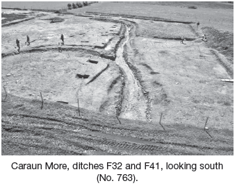
The site was divided in seven areas for better understanding. The largest area (Area 6) uncovered several interconnected ditches. Approximately 20% of the curvilinear ditch F111 was exposed within the CPO. It was over 2m wide and 0.85m deep. The estimated internal diameter is 25m. Two further ditches truncate this one. The smaller one, F32, was circular, with an internal diameter of 23.5m and average width of 2.5m. The other associated ditch, F41, extends 28m from F32 towards south before curving due east and extending for a further 100m, where it crosses the southern boundary of the CPO. These two ditches were contemporary and contained a well-preserved stone revetment. Finds recovered associated with this feature included iron blades and a possible copper alloy earring. These ditches are dated to the medieval period. The larger enclosure ditch, F41, is truncated by a keyhole-shaped corn-drying kiln.
Other features excavated in this area included five small pits, one of which produced Bronze Age pottery sherds. Two large subcircular pits (diameter 6–8m) contained a high concentration of medium-sized stones. Two further pits with similar characteristics were found in Area 2, a further three in Area 3 and another one in Area 7.
Area 4 revealed a linear ditch (F187), the remains of an old field boundary. Two shallow pits, F210 and F262 (0.5m and 1m diameter, 0.11–0.16m deep), which contained ten pieces of slag, may be the remains of a small furnace or hearth.
Area 5 revealed two linear features, F4 and F6. F4 (north-east/south-west, 62m long, 1.8m wide, 0.2m deep) was cut by F6 (north–south, 35m long, 2m wide, 1.2m deep). These two ditches are thought to be part of a medieval field system and may be associated with the activity found within Area 6.
The archaeological remains excavated at Caraun More may represent the remains of several occupation phases, ranging from the Bronze Age to the medieval and post-medieval periods. The majority of the features contain elements characteristic of the early medieval and medieval periods (c. ad 500 to ad 1100). The remains of two revetted enclosing ditches were excavated. These may be interpreted as a dwelling space (a ringfort, F32) with an enclosure for livestock and food processing (F41). The seven large, deep stone-filled pits may have been used as quarrying pits to source the stones used in the construction of the revetments and drying kiln. However, quarrying here may have been more recent.
The position of the site, on a low ridge with expansive views to the south, north and west, may suggest it was utilised for defensive purposes. The site is also situated close to the main concentrations of ringforts that are ‘found in an arc running from Roscommon town through Ballinasloe to Loughrea’ (Stout 1997, 82).
An alternative interpretation of the site is that the smaller enclosure, F32, and its associated ditch, F41, may have formed part of a complex of features related to the control of water.
Excavation works in Caraun More are finished and reporting and specialist analysis are currently being carried out.
Reference
Stout, M. 1997 The Irish ringfort. Dublin.

Unit 4, Dundrum Business Park, Dundrum, Dublin 14