2006:658 - FLEMINGTON, Dublin
County: Dublin
Site name: FLEMINGTON
Sites and Monuments Record No.: N/A
Licence number: 05E0663
Author: Teresa Bolger, for Margaret Gowen & Co. Ltd.
Author/Organisation Address: 27 Merrion Square, Dublin 2
Site type: Habitation site
Period/Dating: Medieval (AD 400-AD 1600)
ITM: E 717340m, N 765028m
Latitude, Longitude (decimal degrees): 53.621908, -6.226242
The development site extends over c. 9.34ha, located in the townland of Flemington, to the north-west of Balbriggan. Previous investigations at the site by Abi Cryerhall and the writer (Excavations 2005, No. 487) had identified an extensive archaeological site (Areas A–E) located along the western edge of the development site. Testing and geophysical survey indicated that the complex extended over c. 1ha and was localised along a ridge of high ground parallel to the western perimeter of the site.
During 2006 further targeted test excavation was carried out at Areas A–E to clarify the nature and extent of the archaeological complex. Monitoring of topsoil-stripping was carried out in advance of construction. Monitoring identified two further archaeological sites (Areas F and G); these appear to be the remains of truncated burnt-mound sites and were located in the low-lying ground generally to the east of the main archaeological complex. Both sites were fully excavated.
Excavation of a substantial section of the main archaeological complex (the eastern portion of Areas A–C) was undertaken during 2006. Preliminary analysis of the results to date indicate that the complex represents the remains of an organised early medieval landscape, emanating from a main settlement focus located in the fields to the north. Dating evidence is based on the retrieval of diagnostic artefacts (several ring-headed pins and possible sherds of e-ware).
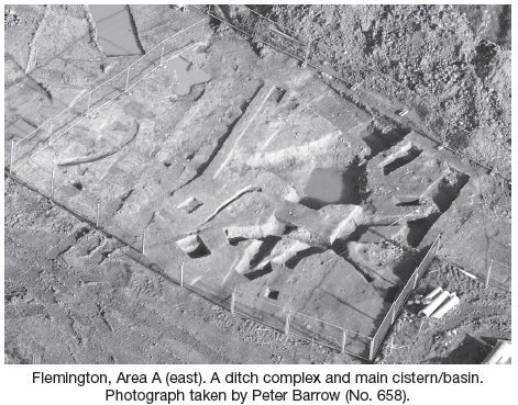
The site is characterised by a complex sequence of ditches, some of which appear to define or delimit areas; others appear to be designed to conduct water into cisterns or basins located at the eastern perimeter of the site, where the main ridge of high ground on which the site is located dropped down into what was originally a low-lying wetland area (encompassing the bulk of the development site). There is evidence for both the recutting of ditches and also the deliberate replacement of ditches, indicating a prolonged duration of activity. Possible corn-drying kilns and bowl furnaces are situated in localised sections of the site, suggesting specific zones set aside for particular activities. Excavation at the site is ongoing.