2006:332 - DUNWORLEY BAY: Dunworley Wreck, Cork
County: Cork
Site name: DUNWORLEY BAY: Dunworley Wreck
Sites and Monuments Record No.: N/A
Licence number: 05E0494
Author: Connie Kelleher, Underwater Archaeology Unit
Author/Organisation Address: National Monuments Service, Department of Environment, Heritage and Local Government, Floor 2, 4–5 Harcourt Road, Dublin 2
Site type: Wreck
Period/Dating: Post Medieval (AD 1600-AD 1750)
ITM: E 547909m, N 536286m
Latitude, Longitude (decimal degrees): 51.576699, -8.751555
Lat: 51 34 922N Long: 08 45 986W
Introduction
In the summer of 2005 the Underwater Archaeology Unit (UAU) undertook a detailed survey and targeted excavation of a shipwreck site in Dunworley Bay in Co. Cork. This followed two previous surveys at the site by the UAU, one as an inspection dive in 2003 and the other as a general survey carried out in 2004 of the wreck site and its wider environs. This work formed part of an investigation being carried out by the National Bureau of Criminal Investigation, in co-operation with the National Monuments Service, the National Museum of Ireland, Customs and Excise officers and the local Garda Síochána. The investigation centred on the possible damage to a wreck site in the bay by a number of divers. The wreck is protected under the 1987 National Monuments Act—as it is a wreck over 100 years old—and therefore requires a licence from the DEHLG to dive on or carry out any work at the site. It was not possible to publish details of this work previously, as the ongoing investigation and all information pertaining to it was sub judice. The case came to a conclusion in February 2007 with the successful conviction of three individuals for tampering with and damage to the protected wreck site under Section 3 of the 1987 National Monuments Act, the first such conviction in the history of the state.
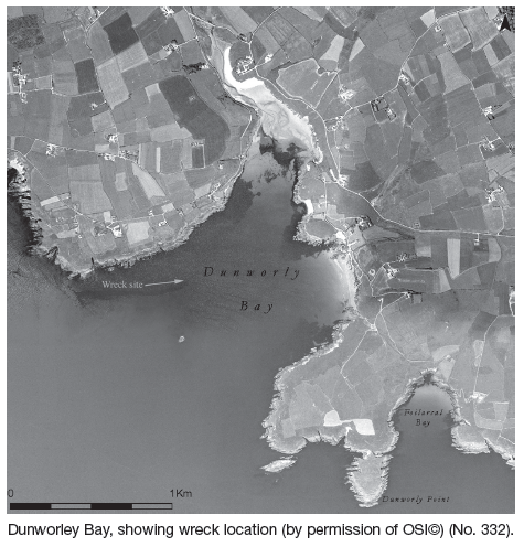
Dunworley Bay is located within the broader and wider confines of Clonakilty Bay in south-west Cork. The bay has a south-west-facing aspect and is bordered at its entrance by a continuous reef system that reveals itself through two pinnacles, the larger Cow Rock and the smaller Horse Rock, with the latter being covered at high tides. Both these pinnacles have proven to be a hazard to shipping throughout the ages. The wreck site lies at the base of the western side of Horse Rock and it appears from the nature and extent of the site that the vessel hit Horse Rock, slid over the reef and came to rest on the seabed to the west. Topographically the bed of the bay is generally flat, with only marginal variations in depth ranging from 22m at its outer extent and becoming shallower as one nears the beach area. The western extent, where the wreck is located, is characterised by a covering of small to medium angular rock. The seabed itself in this area comprises soft, gritty sand and gravel lenses with a high broken shell content. It is coarse but generally stable, being sheltered by the western coastline from the prevailing south-westerly winds.
The wreck site – general overview
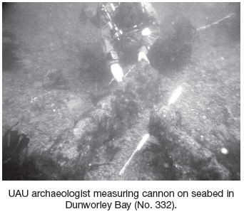
The Dunworley wreck site, which is orientated north-west/south-east and is spread over a distance of some 30m, lies at an average depth of 12m. As recorded in the 2004 survey, the site was characterised by in situ lower hull timbers, six iron cannon and two iron anchors (a large bower and small kedge). Three of the guns appeared to have been disturbed, with one, a small swing gun, showing recent damage. During the course of the illegal activity on the site, a large iron gun had been removed, but the authorities later recovered this. Similarly, a main bower anchor had also been moved from the wreck site and dragged closer to the main beach area in Dunworley, in an attempt to remove it from the water. The hull structure, comprising substantial oak floor timbers and external planking, has both wooden fixings in the form of wooden tree nails and dowels and small, square iron nails. Though preservation is good on the site, some of the timbers display evidence of worm damage by toredo navalis, suggesting that the vessel, at some stage, had sailed in warmer waters where such marine borers are found. Extremely fine caulking, in the form of flat pads, that appear to have been placed rather than pushed between the planks, was also evident and samples of this were taken.
UAU geophysical survey results, May 2005
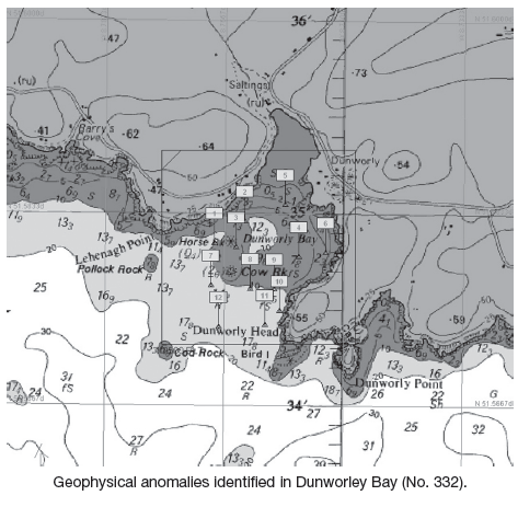
In tandem with the 2005 survey and excavation, the UAU undertook a geophysical survey in Dunworley Bay. This combined side-scan sonar and magnetometer surveys and resulted in a dozen or so anomalies being identified. The objective of the survey was to identify any other wreck remains that may be in the bay and any further wreck structure or artefacts that may not have been identified previously at the Dunworley wreck site itself. All anomalies were dive-inspected, with twelve being mapped, resulting in the positive identification of the Dunworley wreck site and its attendant features and artefacts, showing up as Anomaly 1 on the seabed, all of which had been recorded by the UAU. The survey also located a large 19th-century anchor (Anomaly 2) believed to be from the ship Ecclefechan that was stranded in the bay in the year 1898 and subsequently refloated. A 19th- or early 20th-century iron-hulled wreck in the outer harbour was also identified (Anomaly 12). A number of modern objects were located, including two concrete mooring blocks attached to lobster pots (Anomalies 9 and 10) and the large bower anchor (Anomaly 6) that had been illegally moved off the wreck site. Nothing was found for the remaining anomalies, being either buried or being natural features.
UAU dive survey results
The 2004 dive survey focused on mapping the entire site and resulted in both identifying the nature and extent of the wreck and confirming that the site had been seriously damaged. An area 45m by 45m was dived and surveyed identifying a wide area of clearance, measuring some 23m by 45m, where the site had either been impacted through some introduced downward force (later clarified as being the result of water-jetting) or where objects had been pulled out of the seabed, leaving a hollow in their wake. This was borne out by the recovery by the Customs and Excise and local gardaí of the cannon that had been removed from the site.
The survey methodology used a fixed baseline with a jackstay line extended at a 90° angle to it and the archaeologist at the end of the jackstay travelled from north to south in 1m increments along the baseline. The visual survey was accompanied by a handheld metal-detection survey. Hat-mounted cameras on the diver and voice communication allowed all measurements to be relayed to the surface to be mapped. In this way an accurate 1:50 scaled plan of the general site was achieved. The area of exposed hull timbers, five cannon and one kedge anchor were recorded on the wreck site.
Excavation
The area of hull that had been impacted on by illegal diver activity was recorded in detail and a small portion targeted for excavation. The objective was to assess the damage, gain insight into the construction of the hull and also identify suitable samples for dating purposes. As the area had been previously exposed, only a thin layer of silt and sand covered the timbers. This negated the need to use a suction dredge. Excavation was undertaken by hand, using trowel and hand clearance within a defined grid. All removed silts were searched for potential artefactual evidence and were metal detected. An area measuring 6m by 4m was uncovered revealing 24 tightly spaced flooring timbers over a double layer of hull planking and some possible deck timbers. The orientation of the hull was recorded as lying in a north-north-west/south-south-east direction, the possible deck timbers being located at the southern end of the exposed hull timbers.
Only the southern side of the hull was revealed, with the northern extent being too well buried in the seabed to warrant exposure at that stage. Planking ran the full length of the exposed hull on its southern side, from where it continued into the seabed. Two scarf joints were recorded along this exposed planking, with both being stop-water joints—having a tree nail inserted between the scarves to make it more watertight. This pointed to a well-constructed vessel. The size of the floor timbers, having an average width of 0.2m, and the planking, having a width of 0.2m and thickness of 20–25mm, suggests that it was a medium–large-sized vessel, possibly of 150–250 tons or more, and preliminary analysis of the construction suggests that it may have been Dutch-built (D. Moore, pers. comm.). From the acute angle of the outer planking and the position of the flooring timbers, it appears that a substantial part of the hull may still remain buried.
Two artefacts were recovered during the excavation. The broken swing gun and small kedge anchor were removed, as both had been damaged and were in danger of further damage or even loss as they were mobile on the seabed.
Specialist analysis and dating – the guns
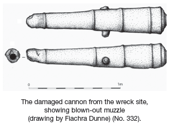
From preliminary research undertaken to date on the guns, a general date range of the late 16th century to the mid-17th century has been obtained (C. Trollop and R. Brown, pers. comm.). Of the six guns recorded, three are medium–large in size (averaging 1.5–2m in length), one is a medium gun (1.2m in length) and the sixth is the broken swing or swivel gun recovered by the UAU. The muzzle and rear swivel arm of this gun has been broken off, with the gun now measuring 0.85m long, but it would originally have been some 1.3m in length or more (c. 4ft, including its swivel arm). All the guns, apart from the one removed from the site, were heavily concreted but several diagnostic features could be discerned. These included tapered trunnions, multiple reinforcement rings and a bulbous muzzle on one of the guns that may point to it having been ringed rather than swelled. These features infer an earlier rather than later date in the 17th century or before.
The gun recovered by the authorities is a cast-iron cannon, 1.6m long. Having been dragged up a rock-cut slipway, it shows several areas of damage, including a broken button, trunnion and impact to its breech area. The muzzle is interesting, as it appears to be misshapen, presumably as a result of a misfire or blow-out, providing evidence that the gun was fired. The swing gun has its swivel yoke still attached and, though heavily concreted, also appears to have its breech block within the chamber. Swing guns had a long usage period, from the 15th through to the 18th centuries, and would have been mounted on the gunwale of a ship and used as close-range weapons.
Dendrochronological dating
As preservation on the site was good, the opportunity was also taken to obtain timber samples from the wreck site for dendrochronological dating. Dr Nigel Nayling of the University of Lampeter joined the UAU on site and took the samples himself. Though several samples had the required ring sequence, none matched the European data sets, so it was not possible to obtain a date. It is intended instead to undertake wood analysis, comparing the Dunworley samples with American, African and other non-European data to try and provenance the timber.
Caulking analysis
Analysis of the sample of caulking, undertaken by Dr Penelope Rogers of the Anglo-Saxon Laboratory in York, identified it to be a flat pad of fibres, the features of which are diagnostic of calf hair (young cattle). It is hoped to obtain a more substantial sample from the wreck site in the future for further, more detailed, analysis.
Historical records and evidence of wrecking in Dunworley Bay
Eleven ships are recorded as having been wrecked in Dunworley Bay. Of these, four fall within the late 16th- and 17th-century date range. These include an unknown Elizabethan-period Spanish galleon, the Rover (wrecked in 1631 following its part in the infamous pirate raid on Baltimore), an unknown African gold-trader of the mid–late 17th century and the Amity (wrecked in 1700), a Royal African Company slave trader. A fifth ship, the HMS Lark, is recorded as being wrecked in the bay in 1682, but research by the author has shown that the ship was stranded in the bay at that time but was later refloated.
Several artefacts have previously been recovered from the area that point to a ship or ships having been wrecked in the bay and which support the existing records. In the late 19th century, painted glass beads were washed ashore at Dunworley. The Amity is recorded as having a cargo of such beads on board. Commonly referred to as ‘trade beads’, they were traded as part of the slave trade. Two elephant tusks, one that was handed over to the UAU by a diver and is now housed in the National Museum, were also recovered from the bay. The African gold-trader and the Amity are both recorded as having a cargo of ‘elephants’ teeth’, as these were highly prized trade objects at that time.
Future work on the site
The identity of the wreck in Dunworley remains unknown to date. What is known is that it has the potential to be an early 17th-century wreck, the substantial remains of which may still lie buried in the sandy silts of the bay. Recorded wrecks from this period are few, so any evidence of these early ships would add immensely to our understanding and knowledge of shipwreck archaeology for this period. The mixture of guns on the Dunworley wreck site, evidenced in the variation in length and type, may suggest that the vessel had not been fitted out with an established complement of armaments, as a naval ship would have been, but that it may be a merchant, pirate or privateer vessel that would have acquired the guns from various sources and often by illicit means. Further analysis is needed, however, to say with certainty what type and date the guns are. Research is continuing and further survey and possible excavation is planned on the site in the future. This may provide more definitive evidence that will help to inform on why it was wrecked, how it was wrecked and what the ship was doing in our coastal waters.