2005:1604 - ASK (Sites 42–44), Wexford
County: Wexford
Site name: ASK (Sites 42–44)
Sites and Monuments Record No.: WX007-076007–18
Licence number: A003/020
Author: Paul Stevens, for Valerie J. Keeley Ltd.
Author/Organisation Address: Brehon House, Kilkenny Road, Castlecomer, Co. Kilkenny
Site type: Standing stone, Ring-ditch, Field system, Furnace, Flat cemetery, Timber circle, Enclosure, Pit-burial and Structure
Period/Dating: Multi-period
ITM: E 717570m, N 663290m
Latitude, Longitude (decimal degrees): 52.707952, -6.260138
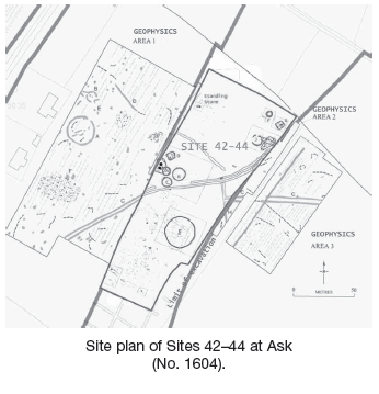
An excavation was carried out, between June and October 2005, of a large cemetery complex in Ask townland, on the western slopes of Ask Hill, 3km north-east of Gorey, Co. Wexford. A total excavated area of 250m in length (north–south) by 48–60m was opened across the width of the road-take. However, geophysical analysis showed that the site continues to the east, west and south-west of the excavated area and road development. Excavation was carried out as part of the archaeological mitigation of the N11 Gorey–Arklow link, jointly funded by Wexford County Council and the NRA. The site was first identified as three separate sites (Sites 42–44) in a desktop appraisal and subsequent centre-line testing by IAC (Mullins 2005).
Analysis of the artefactual and stratigraphic record suggested three provisional phases of activity on the site. Activity appears to span a period between the Late Neolithic/Bronze Age transition to the early medieval/Viking period, although radiocarbon dates have yet to be obtained for any of the features on this site and analysis of the pottery and lithic material is only at an early stage.
Phase 1: land clearance
The site contained a primary phase of universal land clearance, consisting of burnt tree boles and root systems, some containing flint lithic assemblages (including Late Neolithic-type scrapers, hammerstones, flakes and debitage, plus an isolated Mesolithic butt-trimmed flake). The random scatter of charcoal-rich amorphous hollows and scorched-earth spreads occurred across the entire site, pre-dating the archaeological features. This has been interpreted as a deliberate prehistoric land clearance event in advance of Phase 2, perhaps to prepare for it or simply as part of an unrelated agricultural clearance.
Phase 2: prehistoric ring-ditch/cremation cemetery
Phase 2 represented a prehistoric (Later Bronze Age/Iron Age) ritualised funerary landscape or ‘cemetery complex’. Burial was exclusively by cremation burial, in a variety of forms, from penannular and annular ring-ditches, isolated inverted cordoned urns in small pits, clusters of cremation pits in ‘funerary’ structures to comminuted ‘token’ cremations in isolated and clustered pits. Burial was broadly arranged into two complexes or clusters: one to the west and one to the north-east of the site. The former included three annular ring-ditches and two pit concentrations, including two very large post-holes, the latter including two penannular ring-ditches, one with a blue glass bead, and two cremation pit/stake-hole complexes. In addition, eleven isolated cremation pit burials (possibly associated hearths or funeral pyres), isolated shallow pits with complete or broken prehistoric coarseware pots were also observed.
Western ring-ditch complex
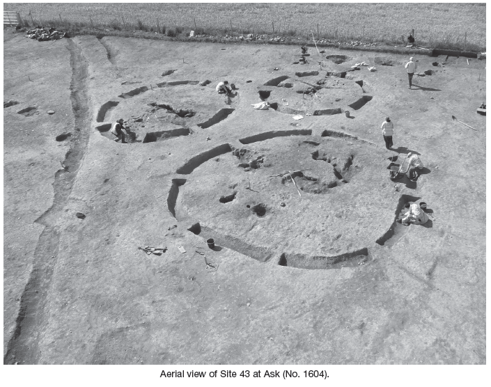
The western quarter of the site represented a cluster of activity flagged in testing as Site 43. This was concentrated into five distinct monuments or structures. One (Structure K) contained two very large post-holes (1.8m deep, 0.8m in diameter, 2.3m apart) enclosed by an interrupted oval alignment (c. 12m in extrapolated diameter) of cremation pits, post-holes and possibly trees.
This activity was post-dated by one (Structure C) of a group of three annular ring-ditches, the largest (Structure A) measuring 11m in external diameter, Structure B measuring 9m in diameter and Structure C measuring 7m in diameter. All three ditches were backfilled by sterile soil and largely devoid of bone or charcoal. However, in Structure A, the ditch was initially open but then subject to a period of intense burning, which apparently originated from the interior, suggesting a raised interior or internal bank. No such evidence of a bank was observed in the others, but Structure B did produce a small quantity of crushed cremated bone, lithics and some very coarse pottery, as well as an internal cremation pit. Structure C, however, did not yield cremation deposits, but did produce a large flint assemblage and also produced pottery.
To the north of the complex was a second group or pit cluster (Structure D), which represented a lozenge or diamond-shaped alignment measuring 7m in length (east–west) by 7m, of burnt areas and 21 pits, some containing cremations, one with cordoned urn pottery fragments and all containing significant flint lithic assemblages. This was postulated as Later Bronze Age and a ritual structure of some kind, perhaps relating to excarnation.
North-eastern ring-ditch complex
To the extreme north-east of this site was a second large complex of prehistoric funerary activity that included two penannular ring-ditches and two/three clusters of cremations pits, pits and stake-holes, similar to that seen in the western complex. Structure I was the larger of the two ring-ditches, measuring 8m in diameter, and had an entrance to the north-north-east and the west (the latter possibly was truncation). This structure was backfilled with a redeposited natural silt but did contain flint, pottery and cremated bone. Structure F, 17m to the north, measured 5.35m in diameter and also had an entrance to the north-north-west, as well as an associated shallow pit. The second smaller ring-ditch contained a large quantity of cremated bone, charcoal (including two burnt planks – possibly from the pyre), flint and a pale blue glass bead. Curiously, Structure I cut an earlier cremation pit, which was then resealed with clay and marked by a post.
A linear alignment of two to three post-holes and pits continued 6m1 east–west into the east baulk and measured 4m in width, probably terminating at the entrance to Structure I. This unusual feature was unclear in function and purpose but did contain one cremation pit.
To the west of this was a confusing concentration of pits, post-holes and stake-holes (Structure H). This structure consisted of an amorphous cluster of over 160 stake- and post-holes, forming a rectangular area, 7m north-west/south-east by 5m. Several possible alignments were noted but could not be confirmed. This area also contained a large crushed prehistoric pot, laid on its side in a shallow depression, similar to that seen in the far south-west.
Isolated cremations and pits
This site produced eleven isolated cremation pit burials, which did not appear to be associated with other structures or monuments; these pits appeared to be scattered randomly across the site though still following the general pattern of following the south-west-facing contour of the hillside. Two such pits had a compartment containing the burial; one was contained in an inverted cordoned urn placed within a small oval cremation pit, possibly covered by a small cairn. Four cremations pits were no more than post-holes and contained very small assemblages of bone.
Several other isolated features contained complete or crushed pottery placed in shallow pits or hollows. However, these pits contained no cremated human bone, although their function appeared to be ritual rather than accidental.
Standing stone
To the north-east of the site and equidistant west/north of the ring-ditch complexes was a standing stone, identified in field survey and assessment as Site 44 (Mullins 2005). This was excavated as part of the mitigation for the road scheme, although it is planned to re-erect it after construction, close to the site.
Excavation showed the feldspathic tuff stone monument was prised and raised from a glacial erratic boulder, which also acted as a foundation. It was also ‘dressed’ in situ to produce a deliberate shape, with patina removed from three sides and the top, leaving one face, looking south-east. Waste pieces were used as packing, wedges and support and show that metal (possibly iron) tools were used to both raise and dress the stone (this is to be confirmed by further analysis). No other archaeological features were located within a 25m radius of this monument, and the two main complexes were 50m away.
Co-axial field system
An undated series of curvilinear parallel double ditches, perpendicular offsets and an interrupted single linear field ditch were also excavated. The double-ditch feature appeared to follow the south-west/north-east topographic contour of the hillside and clearly respected both the western and north-eastern ring-ditch complexes, as it appeared to run into the southernmost ring-ditch, Structure B, discontinuing to avoid cutting it, and terminated at the north-east complex. A perpendicular branch of this double ditch continued south-east and itself branched perpendicular to the north-east, creating a rectilinear enclosure to the east. The interrupted linear feature extended south-east/north-west across the site and terminated at the junction of the double ditch and offset, thus creating an opening and forming a triangular enclosure to the western ring-ditch complex. This was therefore a later, but still prehistoric, field system, interpreted as a co-axial field system.
The double ditch was filled with a uniform sterile silt with some flints and occasional deposits of large stone, whilst the interrupted ditch contained a complex series of fills and also produced slag. This suggests an Iron Age or later date for the ditches.
Phase 3: penannular burial enclosure
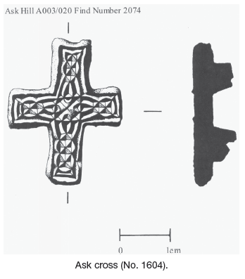
A different and possibly later phase of activity was revealed in the centre of the site (Area C), consisting of a large circular penannular enclosure formed by a narrow slot-trench with large opposing post terminals and post-holes reinforcing the north-north-east-facing entrance. This corral-type circular fenced enclosure measured 24m in diameter and contained seven cremations pits, placed roughly centrally. Cremated bone was also noted from two locations within the northern enclosure gully. Unusually, the structure was largely absent of flint and one burial produced a very fine small decorated bronze cross with Celtic interlaced filigree knot work (identified by Raghnall Ó Flionn as 8th-century, either a horse mount or ecclesiastical loot, with parallels known from a Viking grave in Athlumney, Co. Meath, and from a burial in Scandinavia).
It is therefore suggested that this enclosure may contain Late Iron Age/Early Christian or even Viking cremation(s), but this has yet to be confirmed by radiocarbon dating. If so, the prehistoric burial complex may have been utilised by the pagan invaders, as parallels exist for plundered Irish grave goods in nearly 300 burials from Scandinavia. Alternatively, this could represent a non-clerical Christian burial, as cremation still continued in Ireland until the 8th century and there are five known 7th-century penannular burial enclosures.
Geophysics
In addition to the western and north-eastern complexes, geophysical investigation of the adjacent field to the west revealed a further annular ring-ditch (similar in size to Structure A), close to houses fronting the existing N11. The magnetometry survey, carried out by Network Ltd and funded by the NRA, also revealed the continuation of the double-ditch field system to the south-west and east of the excavated area, as well as the interrupted field boundary to the west. Finally, a second large penannular enclosure (similar in form and size to Structure E and aligned north-north-east) was also revealed in the adjacent west field.
Second standing stone (317500.139 163062.146)
In addition to the excavated standing stone at Site 44, a second standing stone was pointed out to the author by the landowner. This standing stone was not noted in the desktop appraisal and is located to the south-west of the site (outside the CPO), midway down the contour of Ask Hill, overlooking the valley. The stone appeared to be inter-visible with Site 44 and geological assessment suggested that the two were similar in composition and therefore may have been taken from the same outcrop source. Although this stone was not excavated, it is tempting to postulate that the two formed a pair of marker stones to the cemetery.
Finds
Over 3500 artefacts were recovered from this excavation. Of these, around 3000 were worked lithic artefacts (flakes, debitage and some thumbnail scrapers), mostly flint but also chert, siltstone, quartz and granite. In addition, almost 500 sherds of prehistoric pottery (mostly coarseware) and a large quantity of fragmentary and crushed cremated human bone were recovered. Some slag and metal artefacts, including the Early Christian decorated bronze cross, have also been recovered from this site. Analysis of this material is at an early stage and it is hoped a large series of radiocarbon dates will also be obtained.
Discussion
Clearly this is an important site for a number of periods and combines many aspects of archaeological study. However, analysis is at a preliminary stage and further work will be required to bring the site to full publication, which it is hoped will be undertaken in the coming months. Only a part of this site was fully excavated and this has consequences for the preservation of the remainder of the site, which, taken with other findings at Site 37, excavated by Kevin Martin (see No. 1603 above), and Site 39–41 (excavated by Bower in 2006) on Ask Hill, as part of the mitigation of the N11 road scheme, makes the Ask and Tara Hill area even more significant to the locality.