2005:1095 - WHITERATH, Louth
County: Louth
Site name: WHITERATH
Sites and Monuments Record No.: LH012-065001 and LH012-065002
Licence number: 05E0188
Author: Cóilín Ó Drisceoil, Kilkenny Archaeology
Author/Organisation Address: Threecastles, Kilkenny
Site type: Ringfort - rath and Souterrain
Period/Dating: Early Medieval (AD 400-AD 1099)
ITM: E 704678m, N 798622m
Latitude, Longitude (decimal degrees): 53.926363, -6.406160
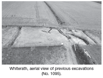
In response to a request from the client, an impact assessment was undertaken prior to the lodging of a planning application for two bungalows at Whiterath. The proposed development area lies directly south-west of and adjacent to two sites excavated by the author in 1999–2000: Whiterath 1 (Excavations 2000, No. 720, 99E0484) and Whiterath 2 (Excavations 2000, No. 721, 99E0485). At Whiterath Site 1 a hollow measuring 15m by 10m contained irregular deposits of burnt soil and charred wood. Associated with it was ‘Western Neolithic’ pottery. At Site 2 was an area 50m by 20m within which were three substantial ditches of Early Christian date, a souterrain and two large refuse pits. Associated finds included souterrain ware, a large collection of metal domestic and ornamental objects and an assemblage of pins and beads of bone. In addition a substantial quantity of animal bone was retrieved. It was not entirely clear, given the constraints of the excavation area, what the association between the three ditches was and consequently a magnetic gradiometery survey was conducted (licence 00R009). This, however, proved somewhat inconclusive and there was still a degree of uncertainty regarding the nature and extent of that site.
Five test-trenches were excavated across the proposed development area. Testing revealed a continuation of the ditch found during excavations in 1999 and confirmed its trajectory and suspicions that it is an ancient field boundary. Trenches 1, 4 and 5 all featured a natural boggy hollow, an extension of the one encountered during excavations at Whiterath 1 in 1999. It had been filled with stone and earth during more recent times. The curving ringfort ditch also identified in the earlier excavation was encountered, suggesting it curves tightly back on itself and continues into the field immediately east of the current site. Gravel from the levelled bank of the ringfort defences was also noted.
Arising from the results of the assessment, a development exclusion zone was placed on the eastern sector of the site. Development proceeded with monitoring, which failed to uncover anything else of archaeological interest.