2005:977 - COONAGH WEST, Limerick
County: Limerick
Site name: COONAGH WEST
Sites and Monuments Record No.: N/A
Licence number: A005/2021
Author: Fiona Reilly, for TVAS (Ireland) Ltd.
Author/Organisation Address: Ahish, Ballinruan, Crusheen, Co. Clare
Site type: Fulacht fia
Period/Dating: Bronze Age (2200 BC-801 BC)
ITM: E 552879m, N 657137m
Latitude, Longitude (decimal degrees): 52.663370, -8.696577
This site was located at the interface between higher dry ground and lower wet ground, which was the flood-plain of the Shannon River before embankments were built to control flooding. The excavation area was located along the southern edge of a large field, adjacent to a stream or modern ditch. Ground level in the field was highest along the strip of land along this boundary ditch. Meandering rush- and iris-filled low areas could be seen throughout the field.
The site was 36m by 23m and primarily identified by two burnt-stone spreads with a ditch cut and streambed between them. Mound 1 was found on the higher ground in the southern central area of the site (6.7 by 4.5m and max 0.26m deep). The modern stream or drain truncated it on its southern side. Once excavation commenced it became apparent that the north-eastern area of the site had been built up in recent times. In antiquity the area to the west and north of Mound 1 sloped down steeply into a water channel.
Mound 2 was 10.2m by 9.5m and 0.02–0.55m deep. It was found on a second area of relatively high ground to the north-west of Mound 1 and on the opposing streambank. The contemporary ground level fell off to the north, east and west. The second stone spread was effectively located on a second island of higher, drier land. It had been truncated on its western side by a brick-hole, from which clay was extracted for brick manufacture.
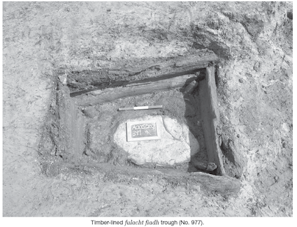
A wooden trough was centrally located within this area of burnt stone and close to the edge of the stream. The trapezoidal cut was orientated north-west/south-east, 1.2m long, 0.7m wide at its north-western end and 1m at the opposite. It was set in a larger depression. This depression, 1.76m by 1.32m, was rounded on the north-western end and truncated by a later ditch at its south-eastern end. The trough timbers were assigned the following numbers: base timbers V–VIII and upper timbers I–IV. A sloping stake was found at each internal corner. All the trough timbers and stakes were alder (identified by Lorna O’Donnell) and were well preserved, with toolmarks evident on many of them. The lower timbers V–VIII were wedge- and chisel-ended stakes, while the upper I–IV were split timbers. Bark was evident on all four lower timbers. Mossy-type material was found stuffed into the triangular gap between timbers VIII and VII. Ten flat stones were placed on the base of the trough. Preserved grass or reeds were found in the base of the trough.
On its eastern and northern sides the burnt-stone spread of Mound 2 sloped downwards into a streambed. This streambed meandered away to the south and north-west and was on average 2.5m wide and about 0.6m deep. The streambed material was removed, but no artefacts or archaeological features were found in it. The southern area of the stream was more complicated. There seemed to have been many cuts and recuts of the stream or ditch. The upper stream fills were later truncated by a ditch which ran along much of its course.
The burnt-stone spread partially covered some of the streambed. It was 10.2m by 9.5m and 0.02–0.55m deep. A large Y-shaped worked ash artefact (identified by Lorna O’Donnell) was found among the burnt sandstones. It looked as if it had been discarded and may have been used to manoeuvre the hot stones from the fire to the trough or as a tool for extracting something from the hot water. It might also have been an upright support for something suspended over the trough or fire.
Since post-excavation work is ongoing, further discussion is not possible at present.