County: Laois Site name: PARKNAHOWN (5)
Sites and Monuments Record No.: N/A Licence number: A015/060
Author: Tara O’Neill, for Archaeological Consultancy Services Ltd.
Site type: Enclosure, Burial ground, Habitation site and Fulacht fia
Period/Dating: Multi-period
ITM: E 634157m, N 673866m
Latitude, Longitude (decimal degrees): 52.814693, -7.493306
An excavation was carried out in response to an assessment, in advance of the proposed M7 Portlaoise–Castletown/M8 Portlaoise–Cullahill motorway scheme between October and November 2005. The work was carried out on behalf of Laois County Council and the National Roads Authority. This report describes the excavation of Parknahown 5, located on Contract 1. This site was identified as a double-ditched enclosure with associated burials, a number of pits, post-holes and linear features, two fulachta fiadh spreads and a second concentration of pits and post-holes outside of the enclosure within Field 32. Contract 1 of the project incorporated the Portlaoise–Cullahill section of the scheme, consisting of c. 14km of motorway, which extends from Aghaboe to south of Cullahill through the townlands from Gortnaclea to Oldtown. Parknahown 5 was located to the south of the River Goul and north of Cullahill Lane. It was located between Chainage 11500 and 12100 of the proposed scheme.
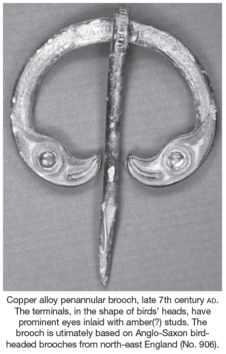
Topsoil-stripping on this site revealed a large number of features, including a double-ditched enclosure which cut an earlier enclosure, a large burial ground, settlement evidence in the form of pits and post-holes and two fulacht fiadh spreads. The double-ditched enclosure was roughly circular and entered Field 32 through the eastern field boundary from Field 33, where it curved northwards where it was cut by modern intrusion. Approximately 50% of these enclosures were located within the road-take and their external diameter measured 70m. The inner ditch measured 3.5m in width and reached a depth of 2.5m. It had a V-shaped profile and contained a large quantity of animal bone, an infant burial and a human skull fragment. This ditch cut an earlier purposely backfilled ditch, which appears to relate to an earlier settlement phase of activity and contained a decorated bone comb dating to the Early Christian period and a number of corroded iron knife blades. A very fine zoomorphic bird-headed brooch was also found in the largest of the enclosure ditches. The double-ditched enclosure would appear to relate to the use of this site as a burial ground. A cemetery containing the remains of c. 600 individuals was excavated. Only part of this cemetery was located within the road-take. The burial ground began in the Early Christian period and appears to have continued in use for a number of centuries. All burials were orientated east–west. Finds from the burial ground included bronze ring-pins, bone needles and glass beads, the latter of which were predominantly found with infant burials.
Settlement evidence within the enclosure site took the form of a badly truncated circular slot-trench with associated post-holes and pits. No finds were retrieved from any of these features and no dates have yet been received.
A fulacht fiadh was excavated as part of this site and was located close to the River Goul. It measured 10m by 4m and extended beyond the western extent of the road-take. The spread consisted of loose dark-brown/black silt with 70% heat-shattered sandstones. A simple earth-cut trough was exposed beneath the spread.
A collection of pits and post-holes were excavated towards the southern extent of the site. Finds from these features included iron slag and flint debitage, along with nine flint scrapers.
All of the samples from this site have yet to be analysed and work on site will continue in 2006.

Unit 21, Boyne Business Park, Greenhills, Drogheda, Co. Louth