County: Kildare Site name: SHERLOCKSTOWN, Sallins
Sites and Monuments Record No.: KD014-027 and KD014-042–3 Licence number: 05E0643
Author: Emer Dennehy, Margaret Gowen & Co. Ltd.
Site type: Mill - unclassified
Period/Dating: Modern (AD 1750-AD 2000)
ITM: E 690089m, N 724295m
Latitude, Longitude (decimal degrees): 53.261351, -6.649685
Monitoring of ground-disturbance works associated with the redevelopment of the Coach House and Round House took place in the grounds of Sherlockstown House, Sallins, Co. Kildare. The Coach House and Round House are outbuildings associated with Sherlockstown House, with cartographic analysis indicating they were constructed prior to 1837. An assessment of the site did not identify any medieval fabric within either building. The Sherlockstown estate was established in the 12th century and incorporates Sherlockstown Church (site of) and graveyard, a wayside cross and a tower-house. The remains of the tower-house have probably been incorporated into the present-day house. The church and graveyard were originally located at the estate’s north-west entrance and accessed by an entrenched walkway known as the ‘Monks’ Walk’. Two cross bases are located within the present-day graveyard; it is most likely that these are the bases from two wayside crosses which originally stood in Littlerath townland.
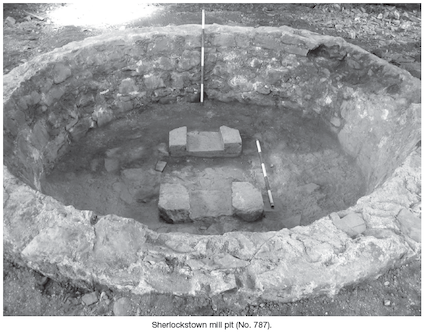
The redevelopment work involved the reduction by 0.3m of ground levels within the Coach House and the Round House in addition to the excavation of a number of service trenches and a 7m by 4m trench to accommodate the insertion of a biocycle unit. A mill pit was identified beneath the modern floor surface of the Round House, indicating that this structure originally functioned as a horse mill. The Round House is, as the name would indicate, circular in plan with an average diameter of 5m. It is accessed by six large segmented-arched doorways. The mill pit, which was also circular in plan, was centrally located within the Round House. It had an average width of 2m (1.35m internal) and an average depth of 0.7m. The pit was lined with mortared limestone blocks and had distinctly splayed edges. Recessed into the base of the pit were two large socket stones which were presumably used to hold the mill mechanisms in place. No mechanisms or millstones were identified during the course of the excavation and the stratigraphy within the mill pit suggests that this mill was deliberately dismantled either at the cessation of use or at some point after. The horse-walk which encircled the mill pit had an average width of 1.3m and this was also filled with demolition material. As the mill pit was to be preserved in situ, the reduction of ground level was restricted to the depth required to achieve the desired finished floor levels. No original ground level was encountered; the cut of the mill pit was not exposed. Two socket stones were also identified within the east and west walls of the Round House. It is presumed that these were used to hold the suspended elements of the mill mechanism.
No additional archaeological stratigraphy was identified during the course of the development works, either during the reduction of floor level within the Coach House or in the excavation of the required service trenches.

27 Merrion Square, Dublin 2