2005:757 - KILDARE: Kildare/Grey Abbey, Kildare
County: Kildare
Site name: KILDARE: Kildare/Grey Abbey
Sites and Monuments Record No.: KD022-029006 and KD022-030
Licence number: 04E0233 EXT.
Author: Emer Dennehy, Margaret Gowen & Co. Ltd.
Author/Organisation Address: 27 Merrion Square, Dublin 2
Site type: Religious house - Franciscan friar and Well
Period/Dating: Multi-period
ITM: E 672691m, N 712252m
Latitude, Longitude (decimal degrees): 53.155807, -6.913143
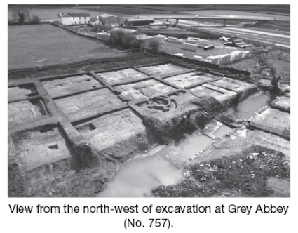
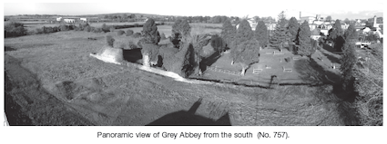
Excavation of a portion of grounds surrounding the remains of the Franciscan friary at Kildare was undertaken in advance of the construction of a retail centre. The proposed development was subject to a detailed environmental impact assessment in 2004, which incorporated the results of a geophysical survey and a programme of archaeological testing (Excavations 2004, No. 831). The development site is composed of three fields. Field 1 abuts the extant remains of the friary church and graveyard and incorporates the cloister and a portion of the graveyard, for which no grave markers survive. An earthen platform known locally as the ‘leper colony’ is situated in the north-west field corner. Field 2 incorporates the remains of Friar’s Well, which at the time of the initial assessment was heavily overgrown and filled with large quantities of agricultural and household debris. It did not retain water. The boundary between Kildare and Grey Abbey townland forms the southern site boundary of Field 1 and the boundary between Fields 2 and 3.
Work in 2005 was confined to the excavation of the Friar’s Well and a portion of the western length of Field 1 measuring 75m north–south by 28m. The townland boundary was also recorded.
A Bronze Age roasting pit measuring 1.8m north–south by 1.25m by 0.48m in depth was excavated in Field 2. It was infilled with three deposits of burnt sandstone in a charcoal matrix.
In Field 1 the remains of the cremation burial of a juvenile and associated marker post were excavated. This burial deposit was sealed with a 0.1m-thick capping layer of brown clay mottled with orange redeposited subsoil. A 2 sigma calibrated 14C date of 1142–1310 BC was obtained from the charcoal of the burial deposit. A number of additional posts and pits were excavated to the immediate east of these features and may also be of prehistoric date.
An Iron Age kiln was preserved beneath the remains of the earthen platform in Field 1. It was figure-of-eight in plan and measured 2.7m in length. The fire bowl, located to the south, measured 0.75m north–south by 0.57m by 0.9m in depth. A 2 sigma radiocarbon determination of 196–4 BC was obtained.
The medieval occupation of the site commenced with the construction of the friary in 1254–1260, with its enlargement under the patronage of Joanna de Burgo taking place in 1350. The area subject to excavation did not incorporate any of the friary’s main buildings but was confined to the earthen platform and garden areas. The platform, which is rectilinear in plan, had been interpreted by Bradley et al. as being of modern construction. The excavation was confined to the south and west edges and illustrated that the platform was constructed on a naturally occurring hill, the topography of which was accentuated through the excavation of three parallel enclosing ditches. The material derived from the excavation of these ditches was centrally mounded to create internal banks. Material retrieved from the ditches contained animal bone, 13th-century floor tiles (identical to those from St Brigid’s cathedral), 12th–13th-century Dublin-type ware and a medieval horse harness pendant. As the interior of the enclosure was not excavated, an interpretation as to its exact function cannot be reached. This structure is referred to locally as a leper colony, which could indicate that it originally functioned as a hospital within the friary compound. It may also have served as an animal enclosure or as the initial settlement area for the friars until such time as the construction work on the friary had been completed.
The remainder of the area within Field 1 was subdivided into two areas, a lawn area where no medieval features were present and a garden area which was criss-crossed with a series of drains and agricultural features. The archaeology of this area illustrates the management of the friary’s water supply, with the drainage specifically designed with central ‘reservoirs’, so that in times of adverse weather excess water was rapidly removed from the site, whereas during dry spells water to irrigate the land was retained within the drains. By the late 13th/early 14th century the division between the garden area and the lawn area was formally defined by a 1.6m-wide ditch.
The excavation identified that the boundary between Fields 1 and 2 followed the course of a naturally eroded streambed, which terminated in the south in the area of Friar’s Well. Friar’s Well was therefore not a well but a pool at the end of this stream. The ‘well’ was created by defining the western bank of the stream through the construction of a low limestone block wall, which was capped with flagstones. The ‘well’ could not be relied on as a water source, for, as seen through the excavation even in winter, it only occasionally retained water and over a three-month excavation period was predominantly a dry feature. The wall would therefore have functioned to define the water source to prolong its periods of water retention. No datable evidence was retrieved from the excavation of the well, but it is probable that it was constructed during the expansion of the friary in 1350.
The townland boundary, which is curvilinear in plan, would also appear to follow the course of a now dry streambed. It was constructed through the excavation of two parallel ditches, the material from which was used to create a central bank. Datable material retrieved from the excavation provides a construction date in the 17th century.
A subcircular structure of 18th-century date was excavated along the western boundary of Field 1. It had an internal diameter of 4.2m east–west by 3.1m (5m by 3.9m externally) and survived to a depth of 1.85m below current ground surface. The basal 0.88m of the structure was built with six courses of limestone blocks, with the presence of joist sockets indicating that this level functioned as a basement. The remainder of the structure was built with ten courses of hand-made brick. It would appear from the number of slates retrieved that this structure was originally roofed. The function of the structure, which is not illustrated on cartographic sources, is unsure, but the basement level of it may have been used as a cold store.