2005:460 - DUBLIN: 3–6 Palace Street, Dublin
County: Dublin
Site name: DUBLIN: 3–6 Palace Street
Sites and Monuments Record No.: DU018-020930
Licence number: 02E0244
Author: Linzi Simpson, Margaret Gowen & Co. Ltd.
Author/Organisation Address: 27 Merrion Square, Dublin 2
Site type: Watercourse, Structure and Building
Period/Dating: Multi-period
ITM: E 715426m, N 734039m
Latitude, Longitude (decimal degrees): 53.343974, -6.266552
Excavations at Nos 3–6 Palace Street, Dublin (formerly the Millennium Park, Dame Street), in April and May 2005 have revealed evidence of the medieval River Poddle, which originally formed part of the eastern defences of Dublin. Although the medieval deposits were not excavated, monitoring of the piling operation revealed that the riverbed was originally 6–7m in depth (from modern ground level) and c. 40m wide, extending as far as the city wall on the east. The monitoring also produced evidence of a post-and-wattle structure set into the riverbed at 4–5m below present ground level. These were not, however, heavy structural timbers and are likely to relate to fencing or some other flimsy structures rather than anything more substantial. The new building was designed to lie above the medieval horizon and, as a result, the medieval deposits were not removed. However, a section of the riverbed dating from the 17th century onwards was excavated and this revealed that the channel was restricted and confined to the western side of the site at some time in the 17th century.
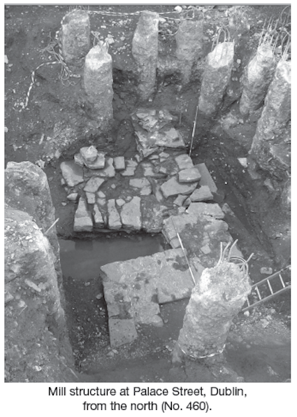
A substantial stone building was then constructed on the riverine deposit, after the main body of water had been diverted from the original riverbed. This large building may originally have been part of a mill, although, as it was very badly truncated, this was difficult to establish. The structure was reused as a foundation for the succeeding Georgian house (built c. 1730) and was demolished at this time to between 0.3 and 0.4m in height (three to four courses high) when the houses were built. The extent of the surviving foundations, however, indicates the presence of a large U-shaped substantial building, measuring at least 4.6m north–south by 3.4m and built of solid limestone block. The slot on the eastern side was quite distinctive, measuring 2m east–west by 1.1m wide at the eastern end and narrowing to 0.8m wide at the western end, and this may have represented the base of the wheel pit. The building originally extended further north, as a section of wall, measuring 0.9m east–west by 1.1m, projected northwards from the north-east corner but was truncated during the later Georgian activity.
At least two phases could be identified in the build of the structure. The northern end, which included the slot, appeared to represent the earliest section of the building. It was built of large solid limestone flags (the largest measuring 0.6m by 0.7m) and stood at 0.3–0.4m in height. It was bonded with a beige/yellow crumbly mortar, which contained visible mortar fleck. The wall was well faced on the west, suggesting that it was placed in a foundation trench and was built into the face of the infill deposits on the western side. The eastern face was less well executed and the cut for the trench was located on this side. This cut measured 0.3m in width by 0.34m in depth and was filled with light-grey gritty gravel that contained red-brick fragments, mortar, cinders, slate, cockleshell and glass fragments. Although this substantial section was built predominantly of limestone, there were numerous bricks within the core of the wall, which could be dated to the late 17th/18th century.
This building may have been part of, or the successor to, the medieval mill known as the Doubleday mill, which is known to have been located on this section of the river. The map of Dublin by De Gomme, dated 1673, depicts the Poddle as generally culverted by this date but shows the river aboveground at this location in much the same way that it does for the Dames mills, further north along the channel (at the corner of Dame Street and Crane Lane). The footprint of the terrace of buildings along Palace Street, built in the late 18th century, was also revealed during the excavation and, in general, the basements survived relatively intact. A quantity of post-medieval pottery and clay pipes were also recovered from the river, including a collection of early clay pipes dating from the 16th century onwards. The site was excavated on behalf of Dublin City Council and the mill structure was preserved in situ.