2005:444 - DUBLIN: 3–15 Hammond Lane/161–168 Church Street, Dublin
County: Dublin
Site name: DUBLIN: 3–15 Hammond Lane/161–168 Church Street
Sites and Monuments Record No.: DU018-020237 and DU018-135
Licence number: 05E0765
Author: Sinéad Phelan, Margaret Gowen & Co. Ltd.
Author/Organisation Address: 27 Merrion Square, Dublin 2
Site type: Gateway, Building and Riverine revetment
Period/Dating: Multi-period
ITM: E 714795m, N 734342m
Latitude, Longitude (decimal degrees): 53.346833, -6.275912
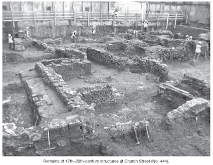
The second phase of excavation commenced at Hammond Lane/Church Street in October 2005. The first phase, excavated by Abi Cryerhall, was carried out in 2003 (Excavations 2003, No. 535, 03E0721). Extensive remains of the 18th- and 19th-century 161–168 Church Street basements, as depicted on John Rocque’s 1756 map of Dublin, were exposed and recorded. A medieval wall was exposed at this level. The stratigraphic context within which the wall foundations were revealed is beneath rubble collapse associated with a sequence of 17th–20th-century activity on the site. The remains of structures of this date were found abutting and constructed up against the medieval wall.
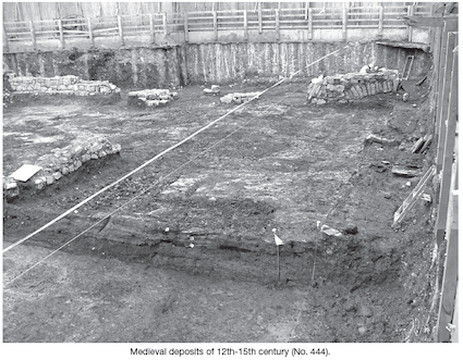
The medieval wall foundations cut through a mixed grey clay layer (containing Dublin-type pottery) of 12th–14th-century date. These clays were recorded across the northern half of the site. The 20th-century cellars truncated this layer in the southern half of the site, Area 2. As a result of these findings, the wall can be stratigraphically dated to the 15th–16th century.
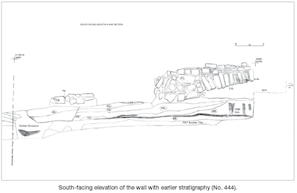
The remains of the wall lie at a depth of 1.35m below the present level of Church Street (3m OD). The wall is orientated east–west. It is not continuous, as it was badly damaged in the 18th and 19th centuries. The surviving fragments and foundations can be traced for a total length of 20m. The remains, which originally incorporated relieving arches, consist of two standing sections, one at the western and one at the eastern end, with two central piers. The eastern section extends for 3m in length by 1.2m in height and includes a portion of a relieving arch. The remains of the piers suggest that these also originally supported relieving arches and that the wall was continuous.
At the eastern end the wall is sitting on a clay surface, which appears to represent a floor, over which a hearth was exposed. Also a burnt sod layer survives in between the piers of the wall and extends 12.5m north–south; this may represent the remains of a collapsed roof. This possible structure measures 5.5m east–west and the wall crosses directly through the centre of it. This area remains unexcavated to date.
To the south of this wall the remains of another, similar, burnt structure of the same date were recorded. Associated with this was a burnt wattle screen sealed by burnt sod, together with associated (in situ) burnt posts. No diagnostic artefacts were recovered and the structure does not appear to be a domestic house.
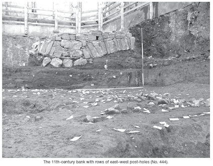
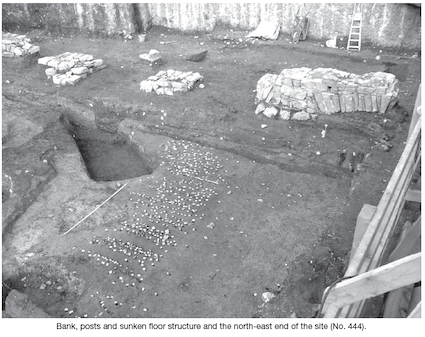
A low clay bank extends into the site from its eastern side and runs in a northerly direction, swinging slightly westwards as it extends to the north of the wall alignment at the north-east corner of the site. A fence was constructed across the top of this bank and the edge of a ditch was recorded to the east, on the Church Street side. The extent of this ditch was not recorded, as it runs beyond the extent of these excavations. This bank may have served as a flood bank, protecting the occupants of the sunken structure to the west. Alternatively it may simply represent the early phases along early medieval Church Street. Because the bank swings westwards, the completion of the excavation in the north-east corner of the site may reveal some evidence for the bank’s outer limit.
The remains of a well-preserved wattle-lined sunken floor structure, which also extends beneath the material retained underneath and to the north of the wall, was recorded 4m west of the bank. A series of east–west rows of stakes and stake-holes both respect and appear to be delimited by the clay bank. All these are roughly contemporary and can be broadly dated to the beginning of the 11th century. Early 11th-century pantiles were recovered in the thin brown organic layer that ran under the bank. It was through this layer that the sunken floor structure and stakes and stake-holes were cut.
Further details of the results of this phase of excavation will be published in Excavations 2006.