County: Clare Site name: CLARE ABBEY, CLAREABBEY
Sites and Monuments Record No.: CL033-120 Licence number: C020
Author: Graham Hull, TVAS (Ireland) Ltd.
Site type: Religious house - Augustinian canons
Period/Dating: Multi-period
ITM: E 534664m, N 675769m
Latitude, Longitude (decimal degrees): 52.828920, -8.969521
Clare County Council intends to create a small carpark/turning space next to the abbey linked to the new N85 by a narrow roadway. Related archaeological excavations took place on a contiguous plot of land that will form the roadway to the carpark (see No. 138, Excavations 2005).
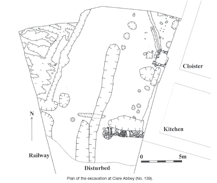
Excavation to the immediate west of Clare Abbey’s south-west corner has produced evidence of human activity dating from the medieval period and continuing into the post-medieval period.
Two features pre-date the construction of the cloister west wall. These features may represent backfilled stone holes that were dug to remove large glacial erratics that would have made the construction of the wall difficult. Westropp (1900) suggests that this wall dates to the 12th century and it will be interesting to test architectural typology with absolute dating provided by radiocarbon analysis.
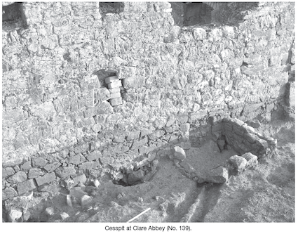
The cloister west wall was partly opened to insert an egress hole for cess and a cesspit with associated drainage was built. A near complete, high quality glass vessel was found at the base of the cesspit and the initial impression of this and other artefactual material indicates a 17th-century date.
Seemingly, in the last few centuries, part of the abbey west wall collapsed and sealed a number of archaeological features (including the cesspit, post-hole alignments and a boundary ditch). Amongst this collapse material was a considerable quantity of limestone roofing tiles. Perhaps this was from the reused and roofed building shown on Dineley’s 1681 sketch. The building that once was the abbey kitchen was open to the skies in 1793.
There is an exciting possibility that some of the archaeological information recorded at Clare Abbey relates to the Jacobite/Williamite war of the later 17th century. Artefactual evidence, in the form of a 1691 coin struck in the Jacobite-held city of Limerick, parts of two spurs and a gunflint (as well as some as yet undated features), may be related to the historically attested presence of military forces in the neighbourhood of Clare Castle. The large body of French cavalry that was stationed at Clare in 1691 would have required grazing for their horses. The flat lands adjacent to a partly roofed institutional structure—the abbey—would have been ideal.
There is a row of holes let into the outer-facing west wall of the cloister at ceiling height. These must have been for horizontal timbers and it is likely that some of the post-hole alignments seen in the excavated area would have supported corresponding timber uprights. It is possible to conjecture that there were ‘soft buildings’ attached to the stonework of the abbey.
A series of parallel and very shallow features were found at the west of the site and may have been cultivation furrows dug for vegetables as part of the abbey’s food supply. An alternative interpretation is that these furrows were lazy-beds, representing the intensive potato-growing economy in the later 18th/earlier 19th century.
In the centre of the site was an area demarcated by two parallel ditches. These ditches and the space between them correspond with a track, shown on the 1840 first-edition OS map, that led to the abbey church gate.
References
Dineley, T. 1681 Sketch of Clare Abbey. In B. Ó Dálaigh, 1998, The Stranger’s Gaze: Travels in County Clare 1534–1950. Ennis.
Westropp, T.J. 1900 The Augustinian houses of County Clare: Clare, Killone and Inchicronan. Journal of the Royal Society of Antiquaries of Ireland 30, 118–35.


Ahish, Ballinruan, Crusheen, Co. Clare