2005:1802 - Carravinally (Ally) clachans, Rathlin Island, Antrim
County: Antrim
Site name: Carravinally (Ally) clachans, Rathlin Island
Sites and Monuments Record No.: ANT001:0121 & ANT001:122
Licence number: AE/05/72
Author: Wes Forsythe
Author/Organisation Address: Centre for Maritime Archaeology, Ulster University
Site type: Settlement cluster
Period/Dating: Modern (AD 1750-AD 2000)
ITM: E 714838m, N 948896m
Latitude, Longitude (decimal degrees): 55.273775, -6.192738
A series of test excavations was carried out on clachan settlements known as Ally Upper (ANT001:121) and Ally Lower (ANT001:122) in Carravinally townland. One of these post-medieval sites was in existence by 1784, when Ally was listed by Hamilton (1839) as one of only three villages or hamlets on the island. The two candidates are situated on east-facing slopes and are c. 1km apart. The test excavations sought to identify which of the settlements at Ally was the 18th-century site referred to by Hamilton and to recover any associated material.
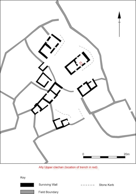
At Ally Upper (314916 449112), excavation focused on the kitchen of a two-roomed house. The most recent floor surface was evidenced by a broken mortared floor set in a layer of tightly packed pebbles. Under this was a mixed brown and orange layer with much charcoal. It was heavily compacted and came off in stiff layers, under which impressions of straw were evident, indicating the floor covering during continuous occupation on an earthen floor. At the same level were a series of flat stones associated with burnt material – a centrally positioned hearth previous to the more recent fireplace. Under the earthen floor was a buff-coloured compact layer into which two stone-lined drains had been set. Finds included a clay-pipe stem, mainly 19th-century ceramics, glass and metal items.
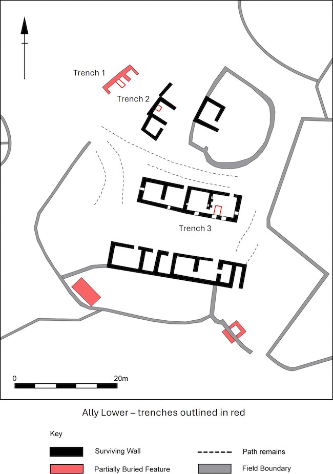
At Ally Lower (314897 448707), three test-trenches were excavated. Trench 1 was in an ephemeral structure, with thin stratigraphy onto bedrock. Trench 2 was in a small dwelling or byre with a paved floor set onto an earthen fill on sloping bedrock. Trench 3 was set in the kitchen of an extended farmstead. A thin layer of topsoil was lifted to reveal the most recent floor structure, comprising incomplete paving and, towards the fireplace, alternating lines of blue and white beach cobbles. The unpaved area of the trench was a loose brown loam, which near the wall continued to descend to form the fill of the foundation trench. Elsewhere the original paving had been bedded in sticky orange clay. Under the clay a loose brown loam containing mortar possibly represents the preparation of mortar on an earthen floor when constructing the walls or making amendments. Under this was a drain feature running longitudinally through the house.
The depth of stratigraphy and nature of the finds associated with the features uncovered would indicate that the dwelling at Ally Upper was more likely to be part of the 18th-century settlement that Hamilton (1839) referred to.
Reference:
Hamilton, W. (1839) Letters concerning the northern coast of the county of Antrim; containing observations on the antiquities, manners and customs of that country. Samuel Hart, Coleraine.