2005:008 - BALLYBOLEY, Antrim
County: Antrim
Site name: BALLYBOLEY
Sites and Monuments Record No.: N/A
Licence number: AE/04/69
Author: Robert M. Chapple, for Northern Archaeological Consultancy Ltd.
Author/Organisation Address: 19 Irwin Drive, Belfast, BT4 3AR
Site type: Habitation site
Period/Dating: Prehistoric (12700 BC-AD 400)
ITM: E 738005m, N 903069m
Latitude, Longitude (decimal degrees): 54.856405, -5.850577
From March to July 2004 monitored topsoil-stripping was carried out in advance of a residential development (Walnut Hollow). The site lay just to the east of the Ballymullock and Ballyboley reservoirs, at a height of some 100m OD. The site lay to the west of Larne and consisted of seven fields covering an area of 91,842m2. It lay mainly on a hillside overlooking and to the south-west of the Walnut Grove development. Previous archaeological works carried out in this area by the writer include the excavation of a pre-bog flint scatter (Excavations 2002, No. 3, AE/02/57), and an undated pit and field boundary was excavated by Simon Large to the north-west of Area 1 (AE/03/41).
Although topsoil-stripping in Areas 1A, 2, 3, 4B, 5 and 7 produced large quantities of artefacts from the plough zone, no archaeological features were discovered. This would appear to be the result of severe land ‘improvements’ carried out from the 1980s onwards. Artefacts recovered here include several thousand pieces of flint, from cores and debitage to complete scrapers and knives, etc., including one flint axehead, along with several pieces of abraded prehistoric pottery.
Area 1, however, did show evidence of surviving archaeological features and was cordoned off to await full exploration. Excavation of Area 1 (4,150m2) was carried out from September 2004 until January 2005. In total, some 447 features were investigated, ranging from pits and post-holes to stake-holes and various forms of gullies. Although rich in artefacts (in excess of 31,000 were recovered), most features appear as isolated groupings with little or no structural cohesion either amongst themselves or with the site in general. While a formal programme of specialist analyses has yet to be undertaken, it appears that the majority of the artefacts date to the Neolithic period, with a smaller proportion of a broadly Bronze Age date. Some flint pieces may be confidently dated to the Late Mesolithic, but these came almost exclusively from within the topsoil zone. While much of the excavated evidence defies easy explanation, some areas may be picked out for discussion.
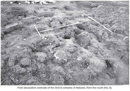
Within Grid 9, an area of black, charcoal-rich material was identified (3.72m north–south by 3.5m). On investigation, this area was revealed to be a complex collection of pits and stake-holes cut into the basalt bedrock. These produced several thousand pieces of flint and decorated pottery. In the former case the emphasis is predominantly on the debitage and unworked pieces, with very few finished items represented. The whole was centred on an east–west vein of degrading quartz and it was into this seam that a small pit (C928) was cut to receive a round-bottomed pot, apparently of Early Neolithic date. This vessel was lifted in block and is currently undergoing conservation. Although much of the recovered artefacts may possibly be regarded as domestic in nature, the mass of features does not provide any viable plan indicating either habitation or industrial activity. These factors, coupled with the presence of the quartz vein and the deposition of the near complete pot, may be taken as arguments for a ritual or ceremonial function.
In Grids 11 and 12, some sixteen post- and stake-holes formed a series of symmetrical pairs, delineating an avenue c. 1m wide and 7.65m long on a north-west to south-east alignment. It appears that this avenue articulated with a further series of eight features to produce a rough circle of 6.68m diameter, enclosing an area of 35.05m2. As with the possible double alignment, the majority of the features that form the circle (six of eight examples) produced prehistoric artefacts. However, it must be stressed that the evidence for this ‘timber circle’ is slight in the extreme and such a hypothesis must be approached with the greatest of caution.
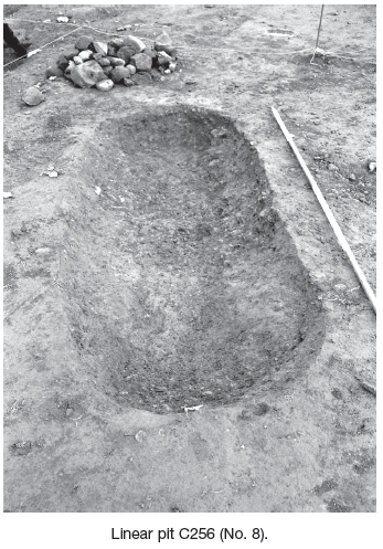
Approximately 2m to the north-east of the avenue alignment was C256, a linear pit (2.3m by 0.97m by 0.3m). This feature contained four fills and produced significant quantities of prehistoric artefacts, specifically flint and pottery. Among the flint were three chipped flint spheres, each c. 60mm in diameter. These artefacts may be interpreted as objects of a ritual nature, though they may have served the more prosaic function of hammerstones for use on materials such as quartz (E. Nelis, pers. comm.).
It appears that a portion of Grids 17 and 18 represented a slight natural hollow (7.25m north-west/south-east by 6.24m) which became filled, either naturally or deliberately, with F709, a mid-brown silty sand. This layer produced numerous prehistoric artefacts, including a possible disc-headed pin of Bronze Age date, which is currently being conserved. Cut into F709 was a complex array of pits and stake-holes. The majority of the stake-holes form an east–west line 4.15m long by 1.26m wide, possibly acting as a series of screens or shelters for activity associated with the C271 and C366 pits. However, the focus of this area appears to be a large flint erratic. It may be that this boulder was deliberately positioned here to form the focus of a cult activity, or that its unusual, but essentially natural, occurrence was the impetus for certain ceremonial activities, similar to those associated with the quartz vein in Grid 9, c. 11.5m to the east. If this erratic was a naturally occurring feature, then the apparent trenching along the western side of the C366 pit may be interpreted as an attempt to expose it more fully, if not dig it out in its entirety. However, no evidence for any deposits was discovered below it. The C271 linear pit (2.6m by 0.9m by 0.4m) was morphologically similar to the C256 pit in Grid 11 and produced a single fragment of a possible chipped flint sphere.
Taken together, this mass of features represents little in the way of a formalised pattern of spatial distribution conducive to explanation in structural terms. For the present time it is perhaps best to see this collection as another example, similar to that of Grid 9, of ritual function or veneration. If such a supposition has any merit, it is tempting to note that the two apparent foci of quartz and flint represent two of the most important materials available to prehistoric peoples in this area.
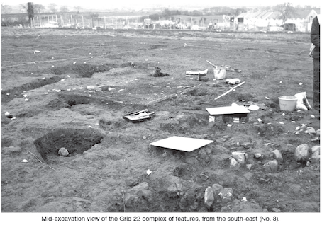
The Grid 22 area represents the third, and arguably the most complex, of the archaeological concentrations on the site. Similar to the Grid 18 evidence, this area appears to have been a slight natural hollow, which was filled with artefact-rich soil. The central concentration of features was confined to an area of 4.86m north-east to south-west by 4.25m, with a series of five intercutting, curvilinear ‘drip-trench’ gullies on the upslope south-western side.
This arrangement may indicate at least two, if not more, phases of structural use of the area. The presence of such gullies may also be taken as an indicator that the remains they protect should be interpreted in terms of a structural function. However, none of the excavated pits revealed anything interpretable as post-pipes nor indications that these features had been used to hold structural timbers. Instead it is currently thought that this complex was an open-air working area, protected from the hill wash by the drip trenches and from the wind by the collection of stake-holes to the south-west, but neither walled nor roofed. Similar to other archaeological concentrations on the site, several thousand sherds of decorated pottery and flint were recovered, although here the numbers of finished artefacts (particularly hollow scrapers) appear to have been proportionally greater.