2004:1883 - PRIESTSNEWTOWN (GSAR Sites 6/6–AG), Wicklow
County: Wicklow
Site name: PRIESTSNEWTOWN (GSAR Sites 6/6–AG)
Sites and Monuments Record No.: WI013-105
Licence number: 04E0401
Author: Ken Wiggins, Judith Carroll & Co. Ltd.
Author/Organisation Address: 13 Anglesea Street, Temple Bar, Dublin 2
Site type: Ring-ditch and Cremation pit
Period/Dating: Bronze Age (2200 BC-801 BC)
ITM: E 728577m, N 709615m
Latitude, Longitude (decimal degrees): 53.121563, -6.079018
The different areas comprising Sites 6/6a–g were identified during monitoring of topsoil-stripping over a large section of Field 11. Two of the areas, 6/6a and 6b, were relatively large and clearly included a great many archaeological contexts. The other components, 6c-g, were much smaller and each contained only one or two features of archaeological interest.
Site 6/6a, located c. 70m west of Site 5 (No. 1882, Excavations 2004, Priestsnewtown, 04E0402), Chainage 920–965, was felt to have archaeological potential when several pits, post-holes and linear features were discerned during the course of topsoil-stripping (Sites 6 and 6a, initially cordoned off separately, were later combined and excavated as Site 6a). In total, eleven pits, five deposits, two post-holes, ten stake-holes, one ditch, two cultivation furrows and two other linear features were revealed on Site 6a.
One of the main features of interest was a large oval pit at the eastern end of the site, C223, which contained heat-shattered stones and a piece of burnt worked flint in the upper fill. Two substantial subcircular pits, C270 and C269, were in close proximity to each other at the extreme western end of the site and each produced a worked flint and numerous pieces of charcoal. A pair of stake-holes located 4m east-south-east of pit C270 may represent the remains of a cooking spit, as a deposit of black charcoal-stained fine sandy silt was located between the two.
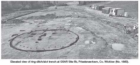
Site 6b lay on the south-facing slope of a gentle rise, Chainage 860–900, and was discovered during monitoring of machine-stripping when various linear features running both perpendicular and parallel to the fence lines were discerned, together with part of an annular ditch and several possible pits, post-holes and deposits. The most significant features on Site 6b were an annular ditch and a sequence of concentric post-holes, as well as four cremation vessels, which were located in three pits enclosed by the ring-ditch. There was a further cremation outside the ring-ditch to the south-east, adjacent to a large linear ditch.
The ring-ditch, C386, was almost perfectly circular, measuring 12.86m (east-west) by 12.76m. The depth of the ditch varied considerably throughout, ranging from 0.19m to 0.43m, depending on the extent of damage from cultivation furrows. Although the edges of the ditch were vertical throughout, the base was quite irregular, ranging from extremely flat to concave or U-shaped in form. For the most part the ditch contained a uniform fill, which was composed of loose mid-brown/grey silty clay with occasional inclusions of charcoal flecks and small pebbles. Fifteen finds were recovered from the fill of the ditch, either sherds of Bronze Age pottery or worked flint.
There were 22 post-holes in the area enclosed by the ring-ditch. Ten post-holes were organised into a concentric sequence inside the eastern half of the ditch. The spacing between the post-holes forming this inner ring was reasonably regular, ranging from 0.62m to 0.8m. The other post-holes were more irregularly distributed, and there was a complete loss of post-hole evidence in the south-western quadrant of the ditch, largely due to agricultural disturbance of the substrate. The post-holes varied in size from between 0.09m and 0.28m in width and from 0.04m to 0.27m in depth.
Three cremation pits, two of which contained one vessel each and the third containing a pair of cremation vessels, were situated roughly in the centre of the area enclosed by the ring-ditch. The most easterly of the pits, C387, contained one virtually intact upright vessel (Vessel 2), complete with burnt bone, charcoal and a flat capstone. The capstone was a subcircular limestone slab measuring 0.21m by 0.23m by 32mm deep. The deposit directly over the capstone contained small pieces of cremated bone, flecks of charcoal and small heat-shattered stone fragments. Vessel 2 measures 185mm high, with a diameter of 0.2m at the rim, tapering to 0.15m at the base. The vessel wall is 0.09m thick. Preliminary analysis of the cremated bone material by Laureen Buckley indicates that the cremated bone fragments below the capstone appear to be of one older juvenile or adolescent. Virtually all the bones of the skeleton were represented.
The most northerly of the three pits, C465, contained only the base and lower part of the body of a vessel (Vessel 5) and scattered, disturbed burnt bone. The loss of the majority of the vessel was due to disturbance by an agricultural furrow. The vessel is 0.17–0.19m in diameter at the base; the vessel wall is 18mm thick. The cremated bone sample from the vessel was highly fragmented and appears to consistof skull and long bone fragments, probably from a single individual.
The most westerly of the cremation pits, C466, contained two cremations within vessels. Cremation vessel C360 (Vessel 4) was the most northerly of the two. Unfortunately, only a limited amount of the lower part of Vessel 4 survived, due to cultivation damage. The vessel is 0.16m in diameter at the base, with the vessel wall of 10mm average thickness; the base itself is 13mm thick. The bone sample from this vessel was small, consisting of skull and long bone fragments.
To the south-east of Vessel 4, within the same pit, was a line of six fist-sized stones forming an arc, oriented north-east/south-west. The line of stones separated Vessel 4 from another cremation vessel, C469 (Vessel 3), which lay immediately to the south. Vessel 3 is a largely complete pot, standing 0.21m high, with a diameter of 0.2m at the rim, tapering to 0.16m at the base. The vessel wall is of 13mm average thickness. The vessel contained 1kg of cremated bone fragments. The sample consists mainly of skull, including mandible, and long bones. Analysis suggests that the remains are of a single adult male.
Another cremation pit, C303, containing an upright vessel (Vessel 1), was found external to the ring-ditch, c. 8m beyond its south-eastern quadrant. Vessel 1 is an impressive, virtually intact, pot measuring 0.29-0.31m in height, with a diameter of 0.27m at the rim, tapering to 185mm at the base; the vessel wall is 13mm thick. Preliminary analysis by osteoarchaeologist Laureen Buckley of the cremated bone contained by Vessel 1 has identified fragments of skull, mandible, long bones, pelvic bones and a toe bone, probably from a single adult individual.
There was a significant concentration of pits and post-holes in the south-east corner of Site 6b, outside the limits of the ring-ditch. The most significant feature was a linear ditch, C426, aligned northeast/south-west. The ditch had an excavated length of 26.24m by 0.85m wide and up to 0.8m deep. It terminated to the north but to the south continued beyond the fence line, delimiting the road-take. The infill consisted of mid-dark-brown silty sand and contained three worked flints. Cremation pit C303, containing Vessel 1, was located c. 1.5m west of the ditch. Ditch C426 truncated the remains of an earlier linear feature, C417, which was cut into the natural on the same axis. Ditch C417 measured 3.6m long, 0.32m wide and up to 0.32m deep. The fill was dark-greyish-black silty sand containing frequent amounts of charcoal and small sub-angular stones. Ditch C426 seems to be contemporary with the Late Bronze Age activity organised about the Site 6b ring-ditch and resembles a field boundary. Evidence for a field system enclosing a ring-barrow was found in 2000 by Ian Doyle at Kilmahuddrick, Co. Dublin, consisting of a shallow north-south linear feature, which could be followed for about 40m (Excavations 2000, No. 225, 00E0448).
Site 6c was located between Sites 6a and 6b, Chainage 910. It was initially perceived to be the remains of a linear feature aligned north-south, extending the full width of the construction corridor and measuring 2-3m in width. The fill was dark-grey silty clay with some gun cartridges scattered on the surface. When a section was excavated through the feature, it was found to be the remains of a shallow machine-dug field boundary ditch and of no archaeological significance.
Site 6d was situated adjacent to the northern fence line, due west of Site 6c and to the north of Site 6b, Chainage 880. The site contained deposit C110 and a small, slightly oval-shaped pit, C108. Deposit C110 was a shallow circular spread of mid-brown silty clay with occasional flecks of charcoal and some small thumbnail-sized pebbles. This spread measured 0.57m in diameter and 0.04m in depth. The pit C108, situated to the south of C110, measured 0.44m in length (north-south), 0.33m in width and was 0.17m deep. The fill comprised mid- to dark-grey silty clay with occasional flecks of charcoal and some small pebbles. There were no finds from this site.
Site 6e was situated c. 20m east of Site 6/6a, Chainage 980, and marked the eastern limit of the Site 6 complex, about 55m west of Site 5/5a. This site consisted of a single circular pit, C105, measuring 0.43m in diameter and 0.2m in depth. The pit contained a compact dark-grey silty clay with occasional flecks of charcoal and 65% heat-shattered stones.
Site 6f marked the western limit of the Site 6 complex, located adjacent to the northern fence line, Chainage 800. This site appeared to consist of two small circular pits, but, when sectioned, the features were found to be tree-root boles and of no archaeological significance.
Site 6g was situated adjacent to the northern fence line, Chainage 910–960 (i.e. east of Site 6c and north of Site 6a). The site comprised two large oval pits, C114 and C3, and one small oval pit, C104. The smallest of the three features, C104, measured 0.85m in length (north-south), 0.48m in width and was up to 0.13m deep. The fill contained loose dark-brown/black silty clay with c. 10% burnt bone, 6-8% small heat-shattered stones and 3% charcoal pieces. The same association of cremated bone with burnt stones occurred in three pits on Site 4 and a pit on Site 5a (see Nos 1881 and 1882, Excavations 2004, Priestsnewtown, 04E0403 and 04E0402).
The second pit, C114, situated at the southern end of Site 6g, was subcircular in plan and measured 1.8m (north-south) by 1.9m and was 0.35m deep. The upper fill was extremely compact and difficult to remove. It consisted of c. 70% heat-shattered stones in dark-brown/black silty clay. Two underlying contexts, C106 and C107, also consisted of extremely compact mottled silty clay and heat-shattered stones with patches of oxidised clay. Fill C106 produced two small flint flakes.
The largest feature on Site 6g was pit C3, situated close to the northern fence line. It was oval in plan and measured 5.5m north-south by 2.5m wide and up to 0.8m deep. Three fills were identified, none of which were strikingly archaeological in character. The material was mostly brown silty clay with occasional flecks of charcoal and fist-sized stones and pebbles. The eastern half of this feature was excavated to obtain a profile, but its purpose is unknown and its archaeological origins doubtful.
The most significant findings made in the course of the GSAR project were the annular ditch and cremation vessels excavated on Site 6b. Following conservation, Vessels 1–5 were examined by Eoin Grogan and Helen Roche. It was found in all but one case that residual black accretion was present on the inner surface of the pots, indicating that the vessels were used as domestic cooking ware before being placed in the ground (i.e. they were not primarily made for use for burials). Vessel 5 may have been unused prior to deposition. From the middle part of the Bronze Age, 1600-1100 BC, specially produced funerary vessels were replaced in burial contexts by domestic pots. The vessels tended to be placed upright in pits, rather than placed as before in stone-lined cists. The GSAR pottery is Late Bronze Age coarseware. Comparable pottery has been securely dated at Haughey’s Fort, Co. Armagh, Mooghaun South, Co. Clare, and Rathgall, Co. Wicklow, to between 1100 and 800 BC. Similar pottery has been found recently at three other locations in County Wicklow: Rathmore, Ballynabarny along the N11, and at Charlesland on the southern fringe of Greystones.
The vessels discovered at Site 6b form a remarkable Late Bronze Age assemblage, but the ring-ditch itself is an exceptional discovery. It is an annular ditch (i.e. a complete circuit) and the cremation vessels confirm that the feature was associated with burial practice. Two aspects of the excavated evidence mark it out as an annular ditch with a difference. Firstly, there appears to have been an inner ring of posts, c. 0.6m inside the edge of the ditch, the posts spaced c. 0.6m apart. Although the sequence of concentric post-holes was only present within the eastern half of the enclosed area, it is likely that it originally extended around the entire circumference but was absent from the western half of the circuit due to ground erosion and disturbance related to cultivation furrows. Secondly, the ring-ditch was narrow and vertical-sided in profile, more like a slot-trench associated with a structure, not a ditch dug to generate spoil for covering burials. The absence of a mound over the burials enclosed by the ring-ditch is confirmed by the inner ring of postholes. Usually such an arrangement of post-holes would be associated with a penannular ring-ditch, denoting the remains of a structure, as for example the Site 2 circular structure excavated by Catherine McLoughlin at Kerlogue, Co. Wexford (Excavations 2002, No. 1915, 02E0606). Another example of the ‘double ringed’ round house was excavated by John Ó Néill at Kilmurry North, Co. Wicklow (Excavations 2001, No. 1368, 01E0572). On the latter site, the outer ring, the slot-trench, was 11.5m in diameter and would have held an outer, non-load-bearing wall of wicker and daub. The inner ring consisted of a circle of post-holes, 8.5m in diameter, and would have supported a thatch or sod roof. A centrally placed hearth was also identified and the entrance to the structure faced south-east.
If there was a structure like a round house at Site 6b—i.e. with a wall in the ring-ditch (more correctly termed a circular slot-trench), just under 13m in diameter, and a ring of internal roof-supporting posts, just over 10m in diameter – it was not an abandoned dwelling that was subsequently reused for burials, as the absence of a break in the slot-trench means it never had a doorway. The diameter of the slot-trench is not too large for the roof to have been supported solely by the inner ring of posts. The excavated circular wooden house at Rathgall, Co. Wicklow, had a diameter of 15m. Additional roof-supporting posts near the centre of the Site 6b structure could have taken the form of prop-posts, resting directly on the floor level or on stone pads on the ground and therefore leaving no cuts in the subsoil.
The excavated evidence suggests that the structure at Site 6b was house-like in form, not unlike the structure at Kilmurry North, but without an entrance and therefore not intended for use for habitation. The ‘occupants’ were in fact the cremated individuals placed in upright vessels in the central area. The evidence points to the existence of a late Bronze Age mortuary structure, the construction method of which bears comparison with recognised house-building techniques of that time. The ‘house’ was built for the dead as a particular mark of veneration stemming from their elevated status in the community to which they belonged. As a flat cemetery distinguished by a substantial ‘dwelling’, Site 6b of the GSAR is unique in Irish archaeology.