2004:1794 - COOLAMURRY, Wexford
County: Wexford
Site name: COOLAMURRY
Sites and Monuments Record No.: WX025-054001 and WX025-054002
Licence number: 04E0325
Author: Grace Fegan, for Valerie J. Keeley Ltd, Brehon House, Castlecomer, Co. Kilkenny.
Author/Organisation Address: —
Site type: Fulacht fia and Kiln
Period/Dating: Prehistoric (12700 BC-AD 400)
ITM: E 691775m, N 637645m
Latitude, Longitude (decimal degrees): 52.482501, -6.648835
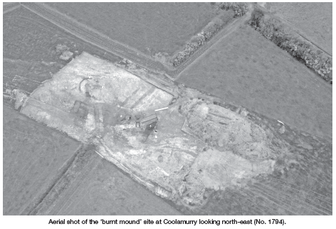
This site was excavated on behalf of Wexford County Council as part of the N30 Moneytucker–Jamestown realignment scheme. The site was located on the north-facing slope of a low rise, just south of the existing N30, in Coolamurry townland. The site was divided by a north-south-running field boundary comprising a single bank with a fosse on either side. The land use was tillage. Where the field boundary joined with the northern limit of excavation, had been a very wet area during the wetter months. Evidence was found on the site for this area having been much larger in earlier times. A series of modern field drains showed how this area had been drained and the water table subsequently lowered. It also showed how this waterlogged spot, around which the main features on the site were arranged, was an area into which water ran from the surrounding fields, particularly to the north and east. Two areas of possible archaeological remains were identified during the testing, Sites 5a and 5b.
Site 5b consisted of an area measuring 10m by 10m. It was recorded as being a possible circular slot-trench. On investigation it proved to be non-archaeological, resulting from recent agricultural disturbance and animal burrowing.
Site 5a consisted of a shallow deposit of ploughed-out burnt material with frequent burnt and shattered stones. Underlying this deposit were a series of features, including five large pits, some of which were oval and some rectangular and of varying dimensions. Associated with these were a number of post- and stake-holes as well as evidence for hearths. These pits followed a similar gradient on the northern-facing slope of a low hill that seems to have encircled a small lake or pond, now drained and reclaimed.
Upslope from this area were a group of features comprising a hearth, a possible drying kiln with two splayed flues, a cobbled surface and associated post-and stake-holes. Immediately west of this group was a curving slot-trench with incorporated post-holes. This seemed to represent the location of a shelter or windbreak. Sherds of prehistoric pottery were recovered from a feature adjacent to the possible kiln.
While this site exhibited many of the features common to other burnt-mound sites, there were certain characteristics that seemed to set it apart. Five troughs was a relatively large number in comparison to the somewhat small amount of burnt spread uncovered on the site. The ploughed-out mound material itself seemed atypical, in that there was not as high a concentration of stone as would be expected. What stone was present was frequently quartz and this was shattered into very small pieces.
Given the multiple troughs and the nearby group of a sheltered hearth, kiln/furnace and cobbled surface, there may be grounds to interpret this entire site as having had some industrial function. What material was being processed was not discernible during excavation. Specialist analysis of soil samples from certain features should give us an indication of what this material may have been.
There is also the possibility that the two areas of activity are unrelated. The various troughs may reflect multiple seasons of usage in an area that was waterlogged and therefore ideal for ‘fulacht’ activity. In either case, definitive interpretation of the site will have to wait until the recovery of specialist information from the soil samples.

