2004:1697 - WATERFORD: John Street (West)/Waterside (South), Waterford
County: Waterford
Site name: WATERFORD: John Street (West)/Waterside (South)
Sites and Monuments Record No.: N/A
Licence number: 04E1304
Author: Maurice F. Hurley
Author/Organisation Address: 6 Clarence Court, St Luke's, Cork
Site type: Town defences and Historic town
Period/Dating: Multi-period
ITM: E 660826m, N 612092m
Latitude, Longitude (decimal degrees): 52.257175, -7.109045
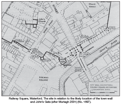
It was proposed to redevelop a site at the junction of John Street (west)/Waterside (south). The site was derelict, the only structural element being the ruined remains of part of the medieval building known as John’s Gate and an associated length of city wall. The standing elements of the walls and gatehouse tower were surveyed. The building is a protected structure in the Waterford City Development Plan. The site was the subject of testing by Sarah McCutcheon in 1994 (Excavations 1994, No. 215, 94E0126). Four trenches were excavated in 2004.
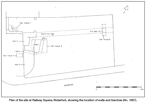
Test-trench A, 1.5m east-west by 0.8m, was excavated to a maximum depth of 1.4m. All strata consisted of disturbed fill (i.e. backfill of trenches covering a sewer pipe). The wall of John’s Gate was exposed at the east side of the trench. The footing of a wall was offset by 0.2m at a depth of 0.95m, continuing to a greater depth than 1.4m.
Test-trench B, 3.3m east-west by 3m, was excavated to a maximum depth of 1.8m. A layer of rubble (0.8m deep) overlay a layer of black silt with a high content of organic material including a few horn-cores. Two stone walls were aligned north-south. The walls were parallel, 1.5m apart. Wall 2 was 0.6m wide and faced at both sides. Wall 1 appears to be part of John’s Gate. A floor consisting of a layer of crumbly lime mortar overlay Wall 1 and extended as far west as Wall 2. The floor extended southwards as far as the east-west blocking wall. Both walls survived to a height of at least 1m but were truncated at a depth of 0.8m below the modern ground surface. The organic silt appears to represent dumping of refuse in the river mud outside the town wall.
Test-trench C measured c. 2.5m east-west by 1.5m. Beneath the modern concrete floor, a layer of stone rubble was removed to a depth of 0.5m. At 0.5m the capstones of a drain were exposed; three of the capstones were removed, revealing a curved drain built of red brick, three courses in height. The drain extended beneath an extant stone wall at the east and a brick wall at the south. Excavation could not be undertaken below this level.
Test-trench D, a substantial stone wall, was revealed at c. 0.3m below the modern surface. The wall was 1.1m wide with a roughly built offset footing c. 0.1m wide at the south giving an overall width of 1.13m. The wall stood to a height of at least 1.3m (seen as depth beneath the surface) and was well preserved, at c. 0.5m below the surface. The top of the wall survived at 2.1m OD and the base was recorded at 0.3m OD. The wall occurred at 3m south of the site boundary. The north wall face was not exposed. The south wall face was vertical. Beneath the rubble (c. 0.5m) a layer of black silt and river mud abutted the wall. The evidence from this trench was similar to that revealed by McCutcheon in 1994.
Reference
Murtagh, B. 2001 Waterford’s watergate. Archaeology Ireland, 15(2), 28–33.