2004:1334 - RAYSTOWN, Meath
County: Meath
Site name: RAYSTOWN
Sites and Monuments Record No.: ME045-036, ME045-036007, ME045-036002, ME045-036008, ME045-036004, ME045-036006 and ME045-036009–16
Licence number: 03E1229
Author: Matthew Seaver, Cultural Resource Development Services Ltd.
Author/Organisation Address: Unit 4, Dundrum Business Park, Dundrum, Dublin 14
Site type: Burial ground, Enclosure, Habitation site, Souterrain, Kiln - corn-drying, Field system and Water mill - horizontal-wheeled
Period/Dating: —
ITM: E 704904m, N 751496m
Latitude, Longitude (decimal degrees): 53.502990, -6.418685
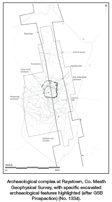
A large archaeological complex was excavated at Raystown, Co. Meath (Site 21), as part of the N2 Finglas–Ashbourne road scheme (Appendix II). Geophysical survey indicated a large subrectangular enclosure with a central division, which contained concentric circular enclosures and a complex series of gullies and linear ditches (GSB 2002).
Testing of the area carried out by Claire Cotter in August–September 2003 (Excavations 2003, No. 1459, 03E1229) confirmed the presence of a series of large enclosures, souterrains and a cemetery. Excavation was initially carried out by Stuart Halliday between 1 October 2003 and 14 January 2004 using the same licence (Excavations 2003, No. 1460) and continued under the direction of the writer from 28 February 2004 to 8 January 2005. From 11 November the site was subject to ministerial directions (A011) under Section 14A(2) of the National Monuments Acts (1930–2004).
The site straddled a north-south ridge (71m OD) bordered to the east by a narrow tributary of the Broadmeadow River. The crest of the ridge was composed of dark-grey/brown boulder clay with frequent angular stones (70m OD). This was surrounded by lighter reddish-brown boulder clay with occasional stones (68-67m OD). Further down the slope, the natural soils were yellow/brown and grey silts with infrequent pebbles and some manganese staining, which ran eastwards to the stream (66m OD). To the west of the road-take the topography was similar, with the ridge sloping gradually westwards, and was bounded by waterlogged ground that appears to have been fed by springs.
The focus of the site covered a total of c.160m north-south by 60m. Associated field enclosures continued for a further 100m northwards. It is evident from geophysical survey that the site covers a much larger area outside the CPO line and the whole site measured up to 210m east-west. The site comprised a graveyard surrounded by enclosures, a northern settlement and souterrains, a surrounding rectangular enclosure, a southern settlement area and the remains of up to seven mills and their associated enclosures.
Graveyard and enclosures
The very stony boulder clay at the crest of the ridge was ringed by a series of enclosures. The central enclosure was 21m north-south by 18m and was bounded by a shallow ring-ditch 0.5m in depth by 1m in width. The fill contained a copper-alloy pin and an iron knife. This enclosure was surrounded by a further ditch, 50m in diameter and concentric with the core enclosure, which was subsequently reduced on the northern side to form a D-shaped space, 50m north-east to south-west by 44m east-south-east to west-south-west, bounded by a ditch 1.5m wide by 1.2m in depth. This enclosure formed the axis for a number of linear north-west to south-east ditches, which were recut numerous times and evidently formed long-lived boundaries. A considerable number of ditches had a starting-point at one junction of the enclosure at the south-east corner and this pattern continued with recutting throughout the life of the site.
The area of the enclosures within the road corridor (approximately half of the overall burial complex) surrounded c. 94 articulated inhumations. Further substantial deposits of disarticulated bone demonstrated that the original number of individuals was significantly higher (the approximate minimum number of individuals for disarticulated remains was 35). The area excavated within the road-take constitutes half of the overall burial ground. The burials were largely confined to within the ring-ditch, but two significant groups of burials clearly postdated the silting of the ditch at the south and east and lie within the outer enclosure. The southern group had a high concentration of juveniles. One of these had a blue glass bead at the neck. A number of the burials within the enclosure were accompanied by artefacts, including an iron knife placed at the ribs, a ringed pin shaft at the shoulder and a coiled copper-alloy ring. The burials varied in orientation from east-west, to north-west/south-east, to southwest/north-east. The burials within the enclosure were generally well spaced and intercutting only predominates at the approximate centre. A significant charnel deposit of unsorted bones was located just north of centre in an irregular-shaped pit. The burials were all extended inhumations with simple earth-cut graves and a small number had features such as earmuffs, headcists and pillowstones. There was an almost equal representation of male and female burials. There was an under-representation of infant burials. A small number of adult male burials had sustained severe blade injuries. An unusual north-south flexed burial was found 15m south of the inner enclosure and clearly pre-dates a phase of the outer enclosure. This was within a pit with scorching containing cereal grain. A series of initial AMS dates for the graveyard suggest a date range of cal. AD 430–610 to cal. AD 800–990 (Wk16306–Wk16309). The ring-ditch enclosure is sealed by burials of 6th- to early 7th-century date. Artefacts within the graveyard soil included ringed pins, a lathe-turned bone spindle whorl, a lignite bracelet fragment and a bone toggle and comb fragments.
Settlement to the north of graveyard
To the north of the series of graveyard enclosures was a metalled surface that ran downslope and covered an area of c. 30m east-west by c. 14m. Within this metalling was a flat area devoid of stones measuring 7.5m east-west by 9m. This area contained a rectangular stone-lined hearth and a series of postholes, which indicate the presence of a structure. A sample from the hearth was radiocarbon dated to cal. AD 770–980 (Wk 16296). A series of curvilinear and linear gullies were cut into the metalling. One of these contained a bone handle with a zoomorphic terminal, which may be of 7th-century date. A sunken metalled feature in this area measuring 1.5m north-south by 3m had a distinctive unmetalled boundary around it, which may indicate a clay-walled structure. The metalled surface was clearly cut by elements of the outer graveyard enclosures. A complex souterrain was constructed immediately to the east of, and cutting, the metalling. The initial construction consisted of a north-south passage with a sharp right-angled turn (westwards) into an east-west passage before subsequently turning north and entering an elliptical chamber, 3.5m in diameter. The sides and chamber were earth-cut with large post-holes at regular intervals. The north-south passage was subsequently replaced in stone.
A larger stone-built souterrain was built immediately to the west of this example. The relationship between these two structures is unclear; however, they did not intercut, despite being in close proximity to each other. This western souterrain has a gradual east-west stone-lined creep before a short right-angled north-south passage drops through a single stone step into a large rectangular chamber 6m east-west by 3m. At the north-west corner a lintelled stone recess was located at floor level. This exited into a ramped north-south earth-cut passage that was cut by the northern mill-race ditch to the north. This passage was filled with redeposited natural. No roof lintels were associated with either structure. There was no evidence of roofing for the wooden-built eastern example, while the western stone souterrain chamber roof had collapsed inwards and clearly demonstrated that it was corbelled. Both souterrains cut a number of gullies and possible linear slot/foundation trenches towards the edge of the road-take. A small scorched circular pit filled with pure oak charcoal was excavated just north of the western souterrain and was dated to 650–830 cal. BC (Wk 16294). Artefacts from this area of the site included a socketed pronged tool (of the form known from Lagore, Cahercommaun and other sites), bone needles and pins, horsebits and knives. Large quantities of animal bone were recovered from the metalled surfaces and from gullies in this area.
To the south of the metalled area further downslope were two figure-of-eight drying kilns and two bowl furnaces, along with a series of post-holes. A form of projecting ring-headed pin was found underlying hillwash in proximity to these features. Here the metalled area was covered by episodes of hillwash (up to 1m of wash deposits accumulating) and subsequent ditches were cut into this. A series of large post-holes, cut into hillwash deposits, suggesting a structure were also excavated in this downslope area.
Subrectangular enclosure
A large subrectangular ditched enclosure was created in the northern area of the site and enclosed the burial ground, previous enclosures and the settlement area containing the souterrains. This measured 55m north-south by 15m within the road-take (geophysics suggests that it was at least 50m east-west) and had a narrow entrance marked by two rounded terminals on its eastern side. This enclosure formed the starting-point for a series of new linear north-west/south-east boundaries and a number of those that related to the earlier concentric enclosures were recut. The rectangular enclosure was recut on at least one occasion and in its last incarnation had another entrance at its north-east angle formed by two rounded terminals. It is unclear whether a bank was associated with this enclosure.
Field system
A series of east-west gullies and small ditches were excavated north of the northern mill-race. These were spread over 90m and lacked the intensity of the main focus of the site. At least one of them had been cut by the northern mill-race. They contained notably less quantities of animal bone and were suggestive of field enclosures attached to the main site.
Southern area
The area immediately to the south of the D-shaped/rectangular enclosure and graveyard was intensively truncated by gullies. The earliest ran north-south and was followed by a succession of east-west gullies. These in turn were succeeded by a further series of gullies, which were constantly recut along the same lines (up to eight times) and ran north-south from the major D-shaped and rectangular enclosure. They ran to a substantial north-west/south-east boundary ditch, which continued for the full 55m across the road-take and had itself been recut on numerous occasions. This was eventually truncated by the southern mill complex, which probably dates to the 10th and 11th centuries. Other features dotted around the area immediately south of the outer graveyard enclosures include a series of hearths and artefacts from the area including glass beads, bone pins, iron knives, an iron candleholder, ringed-pin shafts and large quantities of animal bone. Patches of metalling were found throughout the area and had been heavily truncated by subsequent early medieval activity. During the final phase of occupation in this area, a series of hearths that incorporated a rotary quernstone as a base were excavated. These overlay ditch backfills from the earlier enclosure sequences.
Kilns and gullies
An area with relatively sparse archaeological features was excavated 30m south of the graveyard enclosures and south of the central mill-race. It was bounded by the southern mill-race complex and a substantial north-west/south-east boundary ditch. The area contained two further figure-of-eight kilns. They were bounded to the south by a series of curving intercutting gullies, which drained into the southern mill complex and may have allowed drainage of a structure.
Mills
Northern mill-race
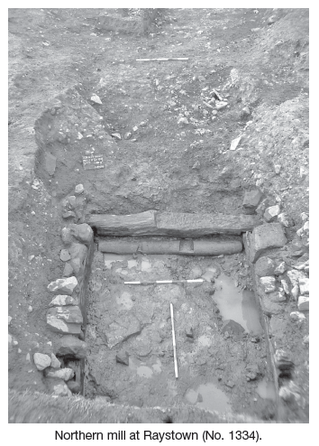
The rectangular enclosure was subsequently cut to the north by a large, deep mill-race, which ran for c. 48m east-west to the edge of the road-take. Beyond the road-take it ran westwards for at least 80m and possibly up to 150m, curving south-west. It ranged from being narrow and V-shaped at the western end of the site (3m wide by 2m deep) to shallow and wide (7m wide by 0.75m deep) and the basal levels indicated that it was utilised to bring water from the west side of the hillside. The wide shallow pond subsequently narrowed to 3m in width. At this point the mill-race dropped 1.9m into a subrectangular mill undercroft (3.5m by 4.5m) that contained oak base-plates overlain by rubble-built stone walls up to 0.75m in height. The mill wheel and millstones had clearly been robbed out. A date of 1020–1170 cal. AD (Wk 16295) was obtained from a heavily burnt deposit halfway through the backfill of the headrace. A possible spatulate-headed stickpin was found in the backfill of the millpond, suggesting 11th/12th-century abandonment. Further AMS dates are being sought for the mill timbers. The tailrace can be clearly observed on the geophysical survey results running beyond the road-take to the stream.
Central mill
A mill-race truncated the complex of ditches in the southern area described above and ran east-west for 30m before reaching an earthcut rectangular mill undercroft that contained extensive collapsed stonework. The mill-race had a relatively level base and therefore was forced to deepen as it progressed westwards uphill to the water source. It ranged from 2.5m to 3m in width and 1.4m to 0.45m in depth. The cut for the mill-race ended some 12m west of the mill undercroft and the water must have been carried above ground for the remaining distance. The mill undercroft measured 3m north-south by 5m by 1.2m in depth and a tailrace ran north-eastwards towards the stream beyond the edge of the road-take. There was no timber found incorporated within this structure and again the wheel and millstones had been removed. The tailrace for this mill truncated a major north-west to south-east boundary, which had been in existence from early in the life of the graveyard enclosures. The southern mill complex was tied into, rather than truncating, this boundary and therefore it is possible that this central mill postdates them. This mill is the latest event in the area and the excavated evidence suggests that the undercroft was horizontal in form.
Southern mill-race complex
The southern mill complex consisted of the remains of at least five mill undercroft structures with their associated headraces, tailraces and bypass channels. The complex forms the effective southern boundary of archaeological remains on the site. These mills drew from four different headraces, which had been recut on several occasions. At least two of these races can be traced on the geophysical survey 185m west of the edge of the road-take. The first mill in the sequence was constructed from four posts, three oak and one willow, and had an in situ bridge sole (base of wheel mechanism), with a number of reset pivot marks for the shaft of the mill wheel. It measured 5m east-west by 4.9m. A wooden base-plate with a flat recess allowed delivery of water into the mill from a stone-and-timber flume. A number of planks indicated that the sides were wooden, with the posts supporting the upper structure. A rotary whetstone was found within the fill.
A separate further rectangular cut with vertical sides and a flume-like slot was discovered immediately to the north. This had its own distinct tailrace. It had no timber and only a small number of stones within and probably represents a robbed-out mill undercroft. Two further mill structures were located in their own cut to the north of this. Both these mills were built with large oak base-plates in a similar fashion to the northern mill. One structure had clearly been cut into the other. They measured 5m by 4.8m and 2.5m by 4m respectively. The remains of a wooden sluice-gate from the conduit were located to the west of these mills.
These mills were fed by a succession of headraces. The latest mill in the complex was fed by a large pond. Each of the previous tailraces were metalled over many times and acted as bypass channels for the new mills, allowing excess water to be dealt with without damaging the wheel mechanism. Finds from the southern mill complex include ringed pins, a decorated copper-alloy strap tag/buckle tongue, a glass bead, a rotary whetstone, pivot stones and a perforated circular whetstone.
It is possible that both the headraces for the northern and southern mill complex formed a large outer enclosure around the site in the 10th-11th century and delimited the boundaries of the core settlement.
Conclusion
The site at Raystown presents a picture of a large rural early medieval settlement that had its origins at the beginning of that period and continued until the end of it. The graveyard demonstrates that the site fulfilled a spiritual purpose as well as being a large working farm, habitation and processing centre. The artefact evidence suggests that the site may have had links with nearby power centres such as Lagore crannog. Post-excavation is at an early stage and extensive analysis will be required to put the site into its wider context.
NB All 14C dates are calibrated to two standard deviations.
References
GSB Prospection 2002 A geophysical survey of the Finglas to Ashbourne road scheme report 2003/43, licence 02R051.