2004:0369 - GRANSHA: Oakgrove Integrated College, Derry
County: Derry
Site name: GRANSHA: Oakgrove Integrated College
Sites and Monuments Record No.: N/A
Licence number: AE/02/76ext
Author: Robert M. Chapple, for Northern Archaeological Consultancy Ltd.
Author/Organisation Address: 19 Irwin Drive, Belfast BT4 3AR
Site type: House - prehistoric, Burial ground and Industrial site
Period/Dating: Multi-period
ITM: E 646011m, N 919916m
Latitude, Longitude (decimal degrees): 55.024667, -7.280419
The site of the new Oakgrove Integrated College lay on the outskirts of the city of Derry, on the eastern ‘Waterside’ bank of the River Foyle, with the historic centre of the city c. 4km to the south-west of the development site. A previous phase of monitored topsoil-stripping had revealed one burnt mound and two groups of pits (Excavations 2002, No. 389). Further monitored topsoil removal in the area of the games pitches revealed eight further areas of archaeological potential (Sites 13–20). On investigation, five were revealed to be of archaeological interest. All of the investigated sites lay along the crest of a north-east/south-west ridge. This ridge provided good views towards the River Foyle in the west and Lough Enagh (western) in the south-east. Excavation took place intermittently between July 2003 and January 2004.
Site 13 was an isolated subcircular pit (0.6m by 0.32m by 0.18m deep) that contained three fills. No dating evidence was recovered. Site 14 was an isolated oval pit (2.54m by 1.85m by 0.26m deep) that contained one fill. This feature produced one struck flint and a possible flint core. Also recovered was one holed piece of local shale, which may have been part of a stone loom weight or roofing slate.
The central focus of Site 17 was a single post-hole surrounded by 28 stake-holes. This collection of features is currently interpreted as the remains of a two-roomed, subrectangular house or hut (2.1m north-east/south-west by 1.88m, enclosing an area of 3.82m2), with an entrance (0.6m wide) and windbreak to the north-east. No dating evidence was recovered. In the area surrounding the house a series of six pits were also excavated. Two of these produced small quantities of Middle to Late Bronze Age pottery. However, there is no evidence to directly link any of these pits to the house.
Site 18 was a collection of seven pits and five stake-holes that formed no cohesive pattern and produced no dating evidence. Two pits showed evidence of in situ burning.
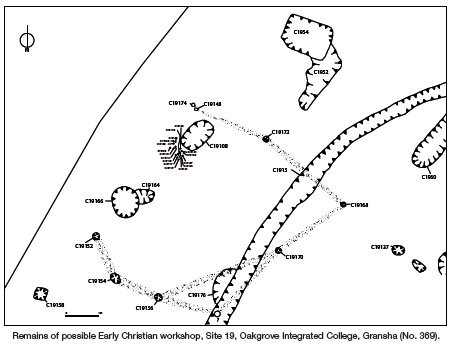
Site 19 is currently interpreted as a Middle to Late Bronze Age enclosed cemetery containing a number of cist burials. A summary of the results of this excavation was published in Archaeology Ireland, Vol. 18, No. 3 (Issue 69), 32–5. However, one aspect of the site not mentioned in that publication was the discovery of the possible remains of an Early Christian workshop. This subrectangular structure would have measured 5.93m (north-east/south-west) by 5.39m, with an internal floor space of 24.61m2. Owing to the lack of post-holes along one side, it is considered that it would have been open to the northwest. The large pit contained considerable quantities of metal slag and is interpreted as a hearth, protected from the prevailing winds by a windbreak composed of sixteen stake-holes.