2004:0235 - CORK: Grand Parade, Cork
County: Cork
Site name: CORK: Grand Parade
Sites and Monuments Record No.: N/A
Licence number: 04E0976
Author: John Purcell
Author/Organisation Address: 17 Balmoral Terrace, Dillons Cross
Site type: Historic town and Town defences
Period/Dating: Multi-period
ITM: E 567301m, N 571812m
Latitude, Longitude (decimal degrees): 51.897505, -8.475117
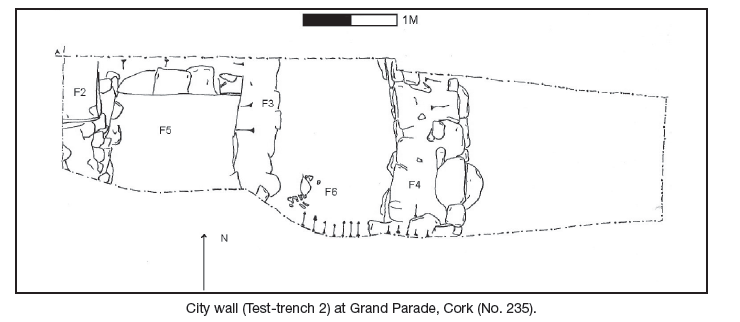
As part of the redevelopment of 77–78 Grand Parade and 1–7 Tobin Street, Cork, testing was undertaken to uncover the line of the medieval city wall and any other archaeological remains within the medieval city. The 13th-century city wall was located below the boundary of Nos 1–2 Tobin Street in line with previous excavation in the area. It was exposed at 0.3m below the current ground level; it was covered by a concrete slab at the east that was part of the boundary between Nos 1 and 2 Tobin Street. The wall was exposed to a depth of 1.8m and was 2.25m in width. At the west the wall had been disturbed or possibly a second wall constructed abutting it. This only extended to a depth of 0.6m. The wall was constructed of evenly coursed limestone blocks, which measure on average 0.2–0.4m in length and 0.2m in height. The east-facing side was almost straight, without any batter. The wall footings were not exposed, due to continuous flooding. To the east of the wall the fill consisted of rubble to a depth of 1.6m and below this was a black humic layer, presumably the remains of medieval dumping outside the city wall. To the west of the wall, rubble was exposed to a depth of 1.5m and a black humic layer was exposed below this. No datable finds were recovered. The boundary wall between 1 and 2 Tobin Street was constructed on the line of the city wall. The fabric of the boundary wall contains no fragments of the city wall.
A second trench to the west uncovered a burial in a black humic layer at 1.4m below ground. The in situ burial included a scapula, vertebrae and a number of rib bones. The skull was recovered (not in situ). The burial was orientated north-east/ southwest and extended into the baulk at the south. No other human remains were visible in the trench.
A series of later walls and a floor surface were also uncovered. Wall F4 was at the east of the trench; this was exposed at 0.2m below the ground level and is constructed of random rubble walling of limestone blocks measuring 0.2–0.4m in length and 0.2m in height. This wall is constructed at the boundary of Nos 2–3 Tobin Street. To the west of this is the corner of structure F3; this was exposed at 0.6m below ground level. This wall is constructed of random rubble walling consisting of limestone blocks, which measure on average 0.3–0.4m in width and 0.2m in height. The wall was exposed to a depth of 1m. This structure encompasses a hardened earthen floor at 0.7m below ground level (F5). Another wall was exposed at 0.2m below the ground level at the west of the trench (F2). This wall was constructed of random rubble limestone blocks, which measured on average 0.3m in length and 0.2m in height.