2003:1869 - DUNGARVAN: Church Street, Waterford
County: Waterford
Site name: DUNGARVAN: Church Street
Sites and Monuments Record No.: WA031-040----
Licence number: 02E0439 ext.
Author: John Tierney, Eachtra Archaeological Projects
Author/Organisation Address: Ballycurreen Industrial Estate, Kinsale Road, Cork
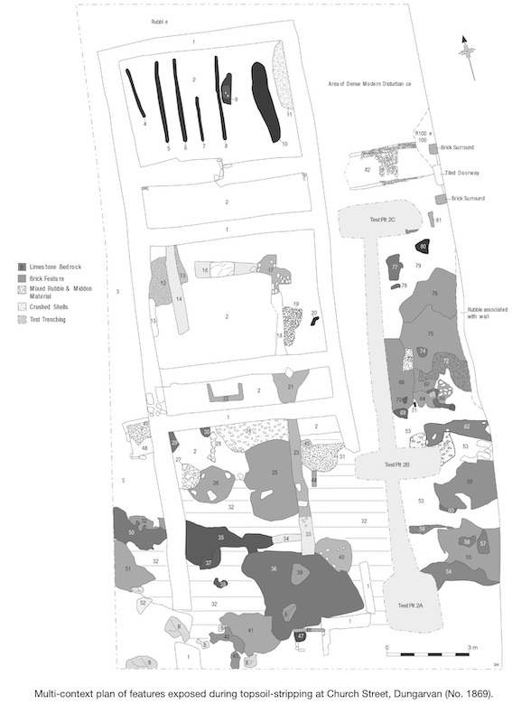
Site type: Pit and Building
Period/Dating: Multi-period
ITM: E 626224m, N 592994m
Latitude, Longitude (decimal degrees): 52.088251, -7.617331
This is the third phase of work carried out at this site under licence number 02E0439. Phase 1 involved pre-development assessment and testing by Daniel Noonan (Excavations 2002, No. 1785). Phase 2 involved the removal of all modern sediments within the development area to the top of any archaeological horizons and the surface recording of this archaeology. Phase 3 consisted of the recording and monitoring of the demolition of the eastern boundary wall and general tidying up of the site.
The site is of a large brown-field site close to the centre of medieval Dungarvan. It is a subdivision of an area of open ground that was formerly part of the larger grounds of the Convent of the Sisters of Mercy. It is located within the line of the 17th-century town wall, beside Church Street, the main thoroughfare from the castle to the medieval church. It was proposed that ten townhouses be constructed on the site of the demolished convent.
The eastern wall of the site along Church Street was stripped of plaster on the interior of the wall. The wall was then photographed and surveyed. Several phases of use and disuse of entrances, windows and other opes were visible in the wall. The demolition of the wall was monitored and no noticeable medieval dressed stone was observed.
During the excavation of a new sewerage pipe trench to the west of the site, archaeological deposits were uncovered at a depth of 1.1m below the ground surface (which is higher in this part of the site than elsewhere). Two linear features and two possible pits were uncovered in the trench, which was orientated from north-east to south-west. The linear features were 0.45m and 0.5m wide from east to west and from north-east to south-west, respectively, and the pits were 1.6m and 2m wide from north-east to south-west. Two sherds of medieval pottery were recovered from one of the pits and one of the linear features. The sewerage pipe trench was excavated to the top of these deposits and, as the trench will not be excavated further, excavation was not deemed necessary.