2003:1846 - DUNGANNON: Castle Hill, Tyrone
County: Tyrone
Site name: DUNGANNON: Castle Hill
Sites and Monuments Record No.: N/A
Licence number: AE/02/116
Author: Robert M. Chapple, for Northern Archaeological Consultancy Ltd.
Author/Organisation Address: 19 Irwin Drive, Belfast BT4 3AR
Site type: Castle - tower house
Period/Dating: Multi-period
ITM: E 679763m, N 862583m
Latitude, Longitude (decimal degrees): 54.505398, -6.768431
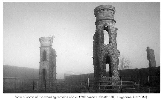
The Police Service of Northern Ireland requested monitoring of a series of 28 test-pits being dug as the foundations for a security fence on Castle Hill, Dungannon. The development lay to the north of Dungannon town centre, at the northern end of Market Square. The site was an irregular area, measuring 40.65m north-south by 28.05m, and encompassed 986.16m2. The development site lay at the crest of Castle Hill in an area surrounded by buildings related to the security forces. As the site lies on the crest of the hill, in a relatively flat plane, it is endowed with extremely good views in all directions, especially to the east and south. The site was the main administrative centre of the O’Neill clan from at least the 14th century until the ‘Flight of the Earls’ in 1607. After this time, a castle was built by Sir Arthur Chichester and around 1790 a gentleman’s residence was built there by the Knox-Hannyngton family. Portions of this structure still stand. Monitoring followed by excavation took place between 27 January and 1 May 2003. Of the investigated pits, all but two produced archaeological remains.
Two short lengths of medieval walling were discovered. The first of these lay in the southernmost portion of the site in pit S4. This portion ran roughly north-north-west/south-south-east and measured 1.9m long by 1.6m thick, surviving to a height of six courses (1.5m). The second section of this wall lay 17m to the east in pit B4–5, where it ran from north-north-west to south-south-east for a length of 1.1m and survived to a height of six courses (1m). The construction techniques employed first involved the cutting of a foundation trench and the insertion of a lime-mortared stone foundation. Above this, a series of well-dressed stones were set to form a battered external face. The core of this wall was formed of roughly coursed, lime-mortared rubble. Owing to the slope of the hill, the surviving, southern (internal), face of the wall did not rise above the contemporary ground surface. This internal face was a continuation of the lime-mortared rubble core, built directly against the differential foundation cut. This internal face could only be observed in the case of the first section of walling where it protruded into the adjacent pit (S3). The second portion of this wall was completely truncated by the insertion of the 18th-century servants’ tunnel (see below). In both cases, the outer faces of the walls were overlain by rubble, interpreted as a combination of wall tumble and deliberate deposition to build up the surface of the hill. It seems unlikely that these portions of walling represent parts of the actual castle walls and may be more reasonably interpreted as fragments of one of the external lines of defence. At present, it appears that these walls are broadly of 15th-century date and relate to the O’Neill tower-house, as opposed to the later, 17th-century, Chichester castle. A broken portion of a 15th-century window embrasure bearing fine punch and stippled decoration was recovered from an 18th-century pavement layer in pit S3.
In the north-eastern corner of the site, three of the fence pits (C2–4) cut through what is currently interpreted as a defensive ditch. A 2.1m-long portion of this feature ran from east to west and measured 5m wide. A maximum depth of 2m was recorded for this cut; as this represented a total of 3m below the current surface level and exceeded the developer’s required working depth, excavation had to be abandoned. It appears that, once cut, this feature was allowed to fill with various forms of debris, including food remains. Large quantities of animal bone (cattle, sheep, pig and possibly horse and deer) were recovered from the ditch fills, along with fragments of fish and bird bones. Many of the larger mammal bones showed distinctive butchery marks. Also recovered were a number of sherds of everted-rim ware, probably of 15th-century date. The ditch also contained a layer of tumbled stone, which included eighteen finely worked hammer and chisel dressed stones. These appear to include a portion of an arch, a decorative roll moulding and one half of a round-headed window.
In the north-western portion of the site (Pit B9–11), a second portion (2.5m long) of a ditch running north-east/south-west was encountered. While much truncated by later activity (see below), this cut still retained a depth of 1.2m and a maximum width of 2.1m. While no conclusive dating evidence was produced by this feature, the capping and cutting of its fills by material of 18th-century date suggests a broadly medieval origin.
The most striking element of the 18th-century activity excavated on the hill was the remains of a servants’ tunnel associated with the Knox-Hannyngton house (built c. 1790). The tunnel originally ran for c. 45m from inside the walls of the house in the south-west, where it emerged, beyond the modern break of slope, in the north-east, in what is believed to have been a farmyard. The current series of excavations encountered this tunnel through a series of five fence pits. Excavation revealed a construction method of lime-mortared stone for the vertical walls (each c. 0.4m thick), roofed by a shallow brick arch, providing an internal space of 1.4m in width by 2m in height. The tunnel had been floored with a layer of well-made cobbles, exhibiting a distinct camber, which allowed any water percolating into the structure to run off at each side. At the southern end of this portion, a doorjamb constructed of well-dressed quoin stones was located. It appears that the majority of the tunnel roof was broken through during the 1950s and filled with various forms of debris from the hilltop. Excavation of this material allowed the recovery of several pieces of dressed stone. Among these are dressed sandstone blocks identical to those used in the surviving towers of the Knox-Hannyngton house, along with some stones of potentially medieval date.
Nine of the fence-pits revealed layers of cobbling. From between the cobbles in pit C3 an iron object was recovered, currently interpreted as a trigger guard from a musket or pistol. Such a find is consistent with the militaristic character of much of the history of this site. Although the majority of these areas of cobbling are supposed to have been of 18th-century date, at least one appears to pre-date the Knox-Hannyngton house. In fence-pit C6, the layer of cobbling was clearly cut by the construction trench for the tunnel. At the latest, this cobbled surface must pre-date the 1790s, though its true date has yet to be ascertained.
In pit B9–11 an area of cobbling measuring c. 4m by 2.5m was encountered. Excavation revealed that this was bedded on a black organic layer, c. 0.1m thick. This material contained numerous fragments of animal bone, oyster shell, pottery and glassware. Given the broad date range for the artefacts recovered from this material, it appears that it was redeposited from elsewhere to act as a bedding layer for the cobbles.
Beneath these layers, a stone-filled foundation trench was uncovered. This feature measured 3m long (south-east/north-west) by 0.4m wide and had a maximum depth of 0.6m. At its south-eastern end, it turned through 90¡, for a length of 0.4m, before disappearing into the section face. At present, this feature is interpreted as a foundation trench for an ancillary building of some sort, such as a workshop or stable, though no secure date can yet be given. As noted above, this foundation cut truncated the upper layers of a ditch of possible late medieval date. However, as this ditch had been cut into the hill slope, the southern (upslope) face was higher than to the north. It appears that a layer of dark-grey clay was deposited to raise the ground surface and form a level construction surface. Amongst numerous fragments of animal bone, etc., the finely crafted stem of a wine glass was recovered from this material.
An article on this site has been published in ‘Excavations at Castle Hill, Dungannon, Co. Tyrone’ (Archaeology Ireland 17, No. 3, 2003, 24–9).