2003:1488 - DRUMIRRIL, Monaghan
County: Monaghan
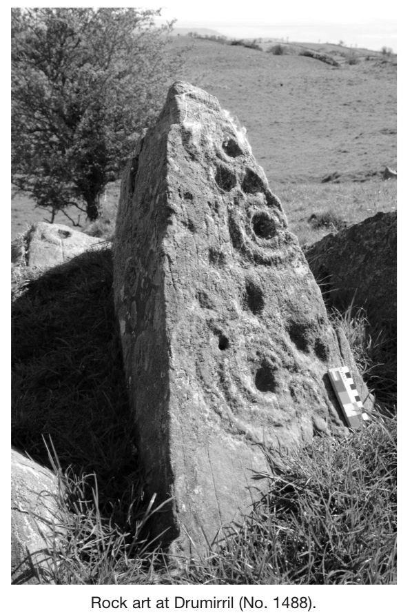
Site name: DRUMIRRIL
Sites and Monuments Record No.: 32:19
Licence number: 03E1231
Author: Blaze O'Connor, University College Dublin
Author/Organisation Address: —
Site type: Rock art, Pit, Enclosure and Burnt spread
Period/Dating: Prehistoric (12700 BC-AD 400)
ITM: E 693744m, N 804550m
Latitude, Longitude (decimal degrees): 53.981705, -6.570771
A small-scale test excavation was conducted within a study area known as the Deer Park, in the townland of Drumirril, Inishkeen. The Deer Park features a particularly dense concentration of rock art on natural sandstone outcrops, which cluster on the small hills and ridgelines that characterise the area. The work was conducted in August 2003 over a ten-day period as part of a doctoral research project funded by the Irish Research Council for the Humanities and Social Sciences. The testing programme followed a large-scale and fine-resolution geophysical survey (licence 02R123), which had successfully identified a range of potential archaeological anomalies near the rock art panels. These included possible pits, post-holes and areas of burning, and several curvilinear enclosures and field boundaries. A number of these anomalies were tested using seven tightly targeted excavation trenches (ranging in size from 1m by 1m to 6m by 2m), several of which revealed substantial prehistoric features.
Trenches 1 (a and b) to 3 were located around a series of rock art panels. Trench 1a was positioned over an anomaly that could not be satisfactorily resolved, though the results for Trench 1b suggest that the geophysical response may have been caused by a metal object embedded in the turf. Trench 1b was excavated over an identical geophysical response close by, and revealed a degraded iron spade head. A pit measuring 1.35m in diameter and 0.22m deep, and containing small fragments of Early Neolithic pottery, was uncovered in Trench 2. Trench 3 revealed part of a large area of outcropping sandstone lying just below the topsoil. A raised and exposed section of the same outcrop features known rock art. The surface of the outcrop had been discoloured and slightly vitrified by intense burning, and a natural linear depression in the stone was filled with a charcoal-rich deposit and capped with stones. Trench 4 was located immediately adjacent to a series of rock art panels. Two small anomalies had been identified in the geophysical survey, but could not be resolved during the excavation of this trench.
Trenches 5 and 6 were positioned in order to investigate an oval enclosure (measuring c. 52m by 35m) that is still visible on the ground surface as a low bank, and which encompasses a hilltop featuring several rock art panels. Trench 5 was located on an internal terrace-like area which had exhibited a significant concentration of geophysical anomalies. The terrace featured a central pit, with a substantial fire-reddened stone setting (1.6m in diameter) defining its upper edge, and a stone-lined post-hole at its base. Surrounding this were two small charcoal-rich deposits, and a series of three stone-lined post-holes. Based on the geophysical survey results, the post-holes probably continue beyond the extent of the excavation and define a trapezoidal-shaped area around the central pit. The trench yielded several finds, including a flint round scraper, a quartz hammerstone, a blue glass bead, cremated bone fragments, charcoal, burnt hazelnut-shell fragments and fragments of a porous vitrified material that is yet to be identified. The features were covered with a layer of angular slabs of local sandstone, probably quarried from the hilltop itself, which appeared to further define the terrace area. A cross-section of the surrounding enclosure was investigated in Trench 6, revealing an outer bank and inner ditch. Associated with the bank was an outer stone revetment and a possible post-hole set into the bedrock at the base of the inner slope. The lower ditch fill and a deposit overlying the outer slope of the bank both yielded Neolithic pottery sherds. A thick layer of angular sandstone slabs also covered the features in this trench.
The findings from the small-scale test-trenches suggest that the wider study area’s significance in terms of prehistoric activity extends beyond simply the presence of the rock art panels.