2003:1390 - DUNBOYNE, Meath
County: Meath
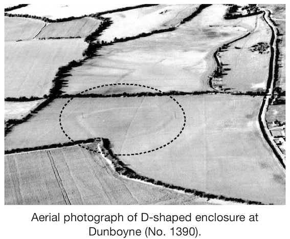
Site name: DUNBOYNE
Sites and Monuments Record No.: N/A
Licence number: 03E1112 ext.
Author: Finola O'Carroll, CRDS Ltd.
Author/Organisation Address: Unit 4, Dundrum Business Park, Dundrum, Dublin 14.
Site type: Enclosure
Period/Dating: Late Medieval (AD 1100-AD 1599)
ITM: E 701309m, N 742099m
Latitude, Longitude (decimal degrees): 53.419271, -6.475887
Following initial monitoring of preparatory groundworks, the remains of a substantial enclosure were uncovered. Excavation of the site was subsequently undertaken. This showed the enclosure ditch surviving to at least 1m in depth throughout the site. Evidence for a substantial recut of the ditch was also uncovered, along with a modern stone drain and numerous field boundaries. During the excavation a number of additional features were uncovered. These included a modern field drain, running parallel and sometimes within the enclosure ditch, as well as a field boundary ditch running from one of the corners of the enclosure.
In general, the monitoring and excavation of the enclosure ditch and associated areas did not reveal a significant amount of finds. Among them were medieval pottery, numerous metal objects that were severely corroded, some leather (including the remains of a shoe) and animal bone. In total 128 finds were recovered. They date to between the 12th and 19th centuries. Most of the finds are associated with one another, being mixed together at some point in the past. This secondary context makes dating difficult.
The enclosure at Dunboyne, while displaying all the characteristics of other similar sites dating to the early medieval period, has only yielded evidence of a 13th–14th-century construction date. Nothing other than the ditch remained of this monument. Evidence was uncovered of a substantial recut of the ditch some time in the post-medieval period. This is evidenced in the mixed range of finds recovered from the same contexts (i.e. medieval pottery mixed with post-medieval glass). This recut was only detected in three sections of the enclosure ditch and may not have extended the full extent of the monument. A relative chronology of activity on the site follows.
Phase 1: Construction of the enclosure, involving the excavation of a V-shaped ditch with the spoil thrown up on the inside to form an internal bank. When completed, the distance from the bottom of the ditch to the top of the bank must have exceeded 3m, with the ditch holding water.
Phase 2: The ditch, having gradually silted up over a considerable period, is recut substantially, making it wider and slightly deeper. The enclosure would still have retained its imposing stature. It is uncertain if this phase represents a resettlement of the monument or if it was just maintenance. The ditch would still have held water, and gradual silting started all over again.
Phase 3: This phase sees a change of use for the enclosure, where additional ditches were constructed as field boundaries (feeding into the enclosure), dividing up the open land into fields. Presumably this phase represents an abandonment of any settlement and a utilisation of the surrounding areas (possibly originally left open for defensive purposes).
Phase 4: This is a destruction phase. It appears that an internal bank was pushed down, backfilling the ditch.
Phase 5: The entire site is reported to have been bulldozed some time in the late 1960s/early 1970s (some reports say it was reduced by as much as 2m).