2003:1376 - GRANGE RATH, Colp West, Meath
County: Meath
Site name: GRANGE RATH, Colp West
Sites and Monuments Record No.: N/A
Licence number: 03E0660
Author: Robert O'Hara, Archaeological Consultancy Services Ltd.
Author/Organisation Address: Unit 21, Boyne Business Park, Greenhills, Drogheda, Co. Louth
Site type: House - Bronze Age
Period/Dating: Bronze Age (2200 BC-801 BC)
ITM: E 711398m, N 773904m
Latitude, Longitude (decimal degrees): 53.702940, -6.312840
The site was discovered during mechanical removal of topsoil under supervision. The site is the latest in a number of excavations within the development, including significant prehistoric and medieval settlements excavated by Donald Murphy (Excavations 2000, No. 748, 99E0472) and fulachta fiadh excavated by Linda Clarke (Excavations 2001, No. 954, 01E0931). A small fulacht fiadh site was located to the south-west of this site and was excavated under a separate licence (No. 1375, Excavations 2003).
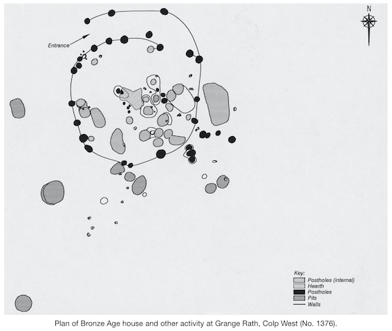
The site consisted of a circular arrangement of posts c. 7m in diameter built without a footing trench, with a number of internal posts forming wall or roof supports. The posts had average diameters of 0.4m and reached depths of 0.6m. The internal supports were four large posts set out in a T-shaped pattern at the centre of the structure. This pattern, while reducing the living space at ground level, could easily have facilitated an upper-floor level in the roof space. The internal floor space of c. 38.5m2 was significantly reduced by the number of pits cut into the subsoil. It is feasible that only some of these pits (primarily all storage pits) were in use at any one time and that some pits were periodically filled in and relocated in order to provide more space. There were two possible entrances, one in the western wall directly through the superstructure and a second more likely point via a possible corridor-type feature in the north-eastern wall.
A number of pits were found both internally and externally. The external pits were rather larger than those within the structure and, it can be reasonably assumed, were used primarily as refuse dumps. The internal pits were generally straight-sided cuts with flat bases and could possibly be interpreted primarily as storage pits. An interesting feature of the internal pit distribution was that nearly all these types of pits are within a very localised area of the house between an arc-shaped setting of posts. This was taken as possible evidence of internal compartmentalisation. There was only one possibility of a hearth on the site, which was roughly centrally placed within the structure and consisted of a spread of mottled oxidised clay, stained grey/black in places by charcoal and ash. It was flanked by a small number of stake-holes, probably the remains of a roasting spit.
Not unusually in sites of this nature, the artefactual assemblage was quite poor and limited to a small number of coarse, undecorated sherds representing at least two vessels, a single flint flake and a perforated mudstone object, possibly a line sinker or loom weight. A greater amount of environmental material was available for analysis, including around 50 charred seed fragments and a small number of nutshell fragments (the seeds were mostly barley and wheat, with various weeds also represented). Over 100 fragments of cremated bone were recovered from a number of contexts. Many of the bone fragments could not be identified to species, however, and only burnt faunal remains survived at the site. A charcoal sample provided a date of BC 1020–790 for the structure.