2003:1218 - ARDEE: Market Street, Louth
County: Louth
Site name: ARDEE: Market Street
Sites and Monuments Record No.: SMR 17:101
Licence number: 03E0058
Author: Richard Clutterbuck, Cultural Resource Development Services Ltd.
Author/Organisation Address: Unit 4, Dundrum Business Park, Dundrum, Dublin 14
Site type: Historic town
Period/Dating: Multi-period
ITM: E 696180m, N 790764m
Latitude, Longitude (decimal degrees): 53.857418, -6.537971
Excavations at the Ardee Credit Union site revealed a continuous sequence of occupation from at least the 13th to the 20th century. Excavation followed on from testing in 2002 (Excavations 2002, No. 1287). The excavation was undertaken from January to April 2003. The site was divided into two areas: Area 1 corresponding with the portion of the site fronting onto Market Street (448m2) and Area 2 corresponding with the back garden (1000m2); the two areas were separated by a tarmac lane leading to the Eircom telephone exchange.
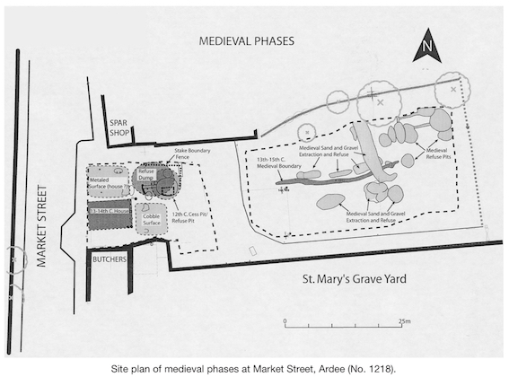
The first phase of occupation consisted of the division of two properties, northern and southern, by an east-west boundary ditch in the early 13th century. The evidence suggests that timber buildings were constructed fronting onto Market Street. The scant remains of the first house in the southern property indicate that it was constructed using wooden posts for support. This house seems to have been replaced with a timber-frame structure whose slot-trench neatly overlay the footprint of the first-phase building; a stone-lined hearth was built at the eastern end of this structure. These structural features are most likely the remains of gable-on houses which fronted onto Market Street. Unfortunately, 18th- and 19th-century buildings have destroyed much of these medieval remains; no evidence for buildings survived in the northern property at all. However, the back yard area of these medieval properties did survive. These areas contained a number of metalled surfaces and a flagstone path leading to a stone privy house built into a cesspit. The medieval archaeology in the back yard area (Area 2) consisted of a 13th-century boundary, contemporary sand and gravel extraction pits and refuse-disposal pits. A boundary ditch separated the two medieval properties; these parts of the properties were presumably used as orchards, gardens or holding areas for livestock. Animal bones recovered during the excavation mainly consisted of cattle, but also sheep/goat and pig.
The range of medieval artefacts included imported pottery vessels from England, France and Spain, Leinster cooking ware, quern stones, iron knives and a spur. Floor tile fragments, ridge tiles and roofing slates recovered from the back garden area appear to have come from the adjacent St Mary’s Church, the parish church for Ardee.
The post-medieval houses built in the site consisted in the main of stone-walled buildings on the street front and towards the middle of the site. A hearth and cobbling, presumably from the interior of a 17th-century house, were found at the southern side of Area 1, but no associated structural remains could be found; a cellar of a 17th-18th-century house was found at the northern end of the site. However, this was superseded during the mid- to late 18th century by a substantial stone house constructed facing onto Market Street. This structure had at least three internal subdivisions; it is unclear if this constituted a single property or a terrace. When this building was demolished in the first third of the 19th century, an empty site was left facing onto Market Street. This gap, along with a range of buildings set back from the Market Street, were depicted on the first-edition 6-inch OS map in 1836. This range of buildings was identified during the excavation. They were constructed from stone, but not to a high standard, indicating that they were perhaps single-storeyed. The quality of the build for these structures suggests that their function was non-residential, perhaps outhouses, sheds or stables. The final-phase structure (demolished in 2002) was built facing onto Market Street; it consisted of one stone-walled building separated into two properties by an internal wall. They functioned throughout the later 19th and 20th century as retail units: a baker’s, butcher’s, grocer’s, public house or post office; in each case the first floor served as accommodation for the retailers. Concrete-block extensions were constructed to the rear of the houses, partially incorporating the stone walls of the earlier 19th-century buildings in the middle of Area 1.
Between the medieval and modern period, the boundary in the back garden appears to have shifted south. However, in the 20th century this boundary was removed. The archaeological and cartographic evidence for this period indicates that the back garden areas were used as orchards. Anecdotal evidence provided by older local people recalled that the northern back garden had been used as a pen for a butcher’s; this appears to correspond with the evidence for modern butchered bone from pits in the back garden.
The excavation has revealed a substantial sequence of occupation from at least the 13th to the 20th century. One feature, the medieval cesspit in Area 1, proved too deep to fully excavate. This feature has been preserved in situ beneath a suspended ground-beam. Post-excavation analysis for the excavation is ongoing.