2003:1023 - KILKENNY: 44–48 St Kieran's Street, Kilkenny
County: Kilkenny
Site name: KILKENNY: 44–48 St Kieran's Street
Sites and Monuments Record No.: SMR 19:26
Licence number: 03E1204
Author: Richard Clutterbuck, Cultural Resource Development Services Ltd.
Author/Organisation Address: Unit 4, Dundrum Business Park, Dundrum, Dublin 14
Site type: Historic town
Period/Dating: Multi-period
ITM: E 650609m, N 655903m
Latitude, Longitude (decimal degrees): 52.651963, -7.252036
An assessment of 44–48 St Kieran’s Street, Kilkenny, was carried out in advance of a mixed commercial and residential development. The site is located on the west side of St Kieran’s Street, within the medieval town of Kilkenny and adjacent to St Mary’s Church. The Civil Survey of 1654–1656 described a number of buildings which occupied this site, which only became vacant around the 1970s. It presently consists of a vacant plot used as a surface carpark and temporary builders’ compound. The rear of the site is covered by raised areas retained by concrete walls faced with reused squared limestone blocks to a height of up to 3m above the carpark surface. This raised area and a number of walls from the building which once occupied the site presently buttress the boundary wall of St Mary’s churchyard.
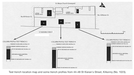
The test excavation was carried out with a three-person team between 18 and 20 August. Five trenches were excavated: two (1 and 2) were excavated by hand on the raised areas and three (3–5) were excavated in the carpark area with the assistance of a mini-digger. Trenches 1 and 2 uncovered a substantial amount of backfill material behind the modern retaining walls, as well as the walls of the 18th–19th-century building which once occupied the site. The trenches in the carpark area confirmed the presence of medieval stratigraphy on-site. Trench 3, measuring 2.5m by 2.3m and excavated to a depth of 1.3m, uncovered medieval features 0.3m beneath the carpark surface. These consisted of a stone wall and a metalled surface, and refuse layers. Trench 4, measuring 2m by 2m and excavated to a depth of 1.8m, exposed the foundations of one of the 18th–19th-century buildings; further excavation revealed approximately 1.4m of medieval stratigraphy in what appears to have been a pit or a ditch. Trench 5 measured 3m by 2m and 1.4m deep. It exposed a wall and a metalled surface of probably medieval date, as well as refuse or occupation layers.
In general the stratigraphy ranges in depth from 1.64 to 0.73m. The trend of the stratigraphy runs from relatively thick at the north end of the site (Trench 5) to relatively shallow to the south end (Trench 3), with the thickest deposits in the middle of the carpark area (Trench 4). It is also apparent from Trench 4 that the archaeological material may be striking deeper from west to east. The medieval deposits generally consist of dark-brown sandy clays containing sherds of medieval pottery and tile, as well as animal bone (sheep/goat) and oyster shell. These would appear to be midden deposits. A metalled surface was encountered in Trenches 3 and 5, probably representing the remains of the floors of a medieval structure or an open area such as a yard or path. The post-medieval features consisted of walls, drains and rubble associated with the buildings demolished 30 years ago. Most of this material is contained in the top c. 0.4m of the deposits. Somewhere within these deposits are the remains of the buildings described on the Civil Survey from the mid-17th century; the remnants of a glazed roof tile, possibly a ridge tile, were recovered from the upper archaeological layer in Trench 4. In all likelihood these late medieval or 17th-century remains incorporated medieval building fabric and were in turn incorporated into the 18th- and 19th-century buildings, much like the remaining buildings along the west side of St Kieran’s Street.
In total 113 finds were retrieved, of which over 60 were from a medieval context. Most of the modern finds were from Trenches 1 and 2. These consisted of various tableware sherds and a complete penny inkpot which dates to the 19th or earlier 20th century; a complete 19th-century clay pipe was also recovered. The majority of the medieval pottery sherds were recovered largely from Trenches 3–5 in the carpark area, where the deposits are deepest. The assemblage was roughly evenly divided between pottery with orange and buff fabric, although the majority contained a grey interior indicative of an oxygen-starved or oxygen-reduced atmosphere during firing. The glazes were, in most cases, dark-green or clear, with specks of green from the use of a galena lead glaze. Most were consistent with pottery forms dating to the 13th and 14th centuries. The pottery is a mixture of local Kilkenny wares and English wares from the Bristol region. Two sherds of south-western French Saintonge were recovered. Four pieces from two late medieval or early modern glazed roof tiles were also found. In addition, fourteen medieval metal artefacts were recovered. All were iron and, although a few were identifiable as possible nails, the majority were very corroded and have been sent to a specialist for analysis and conservation.
An analysis of the standing walls on the site has revealed nothing of outstanding architectural significance. The boundary wall with St Mary’s Church appears to date to the 18th century. The remains of the buildings that abut St Mary’s graveyard are all later 18th- or 19th-century in date. The significance of these walls lies in the fact that they are the last surface remains of the buildings which once fronted onto St Kieran’s Street between Nos 43 and 49. The modern upper and lower retaining walls are functional structures designed to consolidate the boundary wall with St Mary’s churchyard. They consist of mass concrete walls faced with reused cut and dressed stone to present an aesthetically pleasing face.
An archaeological management plan has been proposed to minimise or eliminate the potential impacts of the development on the archaeological deposits on-site. The archaeological material on-site was found to be, on average, 0.2–0.25m beneath the current ground surface. The proposed development’s finished floor levels (46.720m OD and 46.870m OD) are between 0.35 and 0.45m above the top levels of the recorded archaeological material. The proposed mitigation measures recommended the preservation of archaeological material in situ.