2003:1013 - KILKENNY: 1 Irishtown (Rear of), Kilkenny
County: Kilkenny
Site name: KILKENNY: 1 Irishtown (Rear of)
Sites and Monuments Record No.: N/A
Licence number: 02E1592
Author: Ian W. Doyle, for Margaret Gowen & Co. Ltd.
Author/Organisation Address: 2 Killiney View, Albert Road Lower, Glenageary, Co. Dublin
Site type: Historic town and Riverine revetment
Period/Dating: Multi-period
ITM: E 650339m, N 656273m
Latitude, Longitude (decimal degrees): 52.655313, -7.255969
The River Nore (Kilkenny City) Drainage Scheme, which has been ongoing since July 2001, also includes flood-relief works on the River Breagagh. The works on the Breagagh include the lowering of the riverbed in selected locations, as well as the widening of the river channel. One such location for the widening of the channel is to the rear of and adjoining No. 1 Irishtown. This site is on the northern bank of the Breagagh, approximately 300m east of the Breagagh–Nore confluence and immediately north-west of Irishtown Bridge. This is located in the historic borough of Irishtown, which evolved in the area around St Canice’s Cathedral. The site at No. 1 Irishtown lies some 150m to the south-west of St Canice’s Cathedral and some 120m to the west of the Abbey of St Francis. Excavations commenced at this location in October 2002 and continued until April 2003 (Excavations 2002, No. 1015).
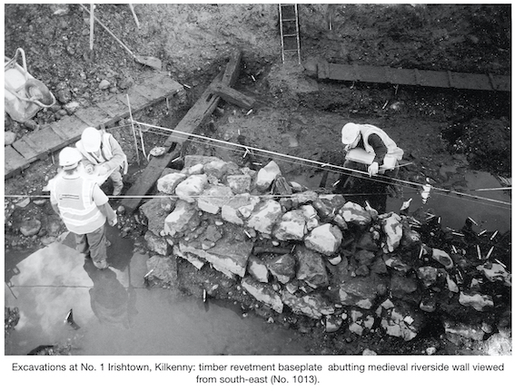
The presence of the River Breagagh ensured the preservation of timber remains, as well as other organic remains. The investigations revealed the presence of a series of riverside wooden post-and-wattle fences dating from the medieval period, the remains of a post-and-wattle structure with associated floor surfaces, a substantial medieval masonry wall, which acted as a riverside wall, and the presence of an in situ oak base-plate for a medieval riverside revetment similar to examples uncovered in Dublin and Drogheda. Five phases of activity were identified from the excavations.
Phase I consisted of a riverside fence and a post-and-wattle structure. The fence, which had been driven into river gravels, ran for a length of 5.3m east–west but with a deliberate turn at the western end for a length of 0.7m north–south. The wall of a post-and-wattle structure was revealed running parallel to this riverside fence. This post-and-wattle wall was partly disturbed, but a series of clay floor surfaces with organic accumulation were revealed. From the small floor area which survived, some cautious dimensions can be worked out for the structure. The remains exposed measure some 8m east–west in length with a floor width of some 2.5m exposed. The lack of pottery associated with any of this material suggests a date perhaps at the end of the 12th century.
During Phase II the same orientation of riverside walls was maintained. A post-built fence, more substantially made than its Phase I predecessor, was uncovered. This fence maintained the same alignment as its predecessor: east–west but with a turn to the north also. A confusing sequence of floor deposits was also uncovered in the area previously occupied by the Phase I structure. However, no walls were found for any of these floor surfaces. It is of note that the post-and-wattle fence from the Phase I structure was covered over with gravels, but that the orientation of the newly deposited surfaces remained the same. In response to this series of deposits, the writer feels there is sufficient evidence to suggest the former presence of a sill-beam timber structure in this area. Such a structure could have been founded on horizontal wooden base-plates laid on the ground surface from which timber walls would have risen. The complete removal of such timbers, by either flooding or human activity, could result in a series of floor surfaces remaining as the only trace of such a building.
A layer of dark-brown organic material accumulated during this phase also. This layer was associated with the occupation of the property and it seems to represent dumped material that built up at the rear of the plot. This material may have been deposited out of convenience, or more probably was dumped so as to build up the ground level above that of the River Breagagh. This dark-brown fibrous organic material contained pottery of local manufacture but also small quantities of Ham Green and French wares. The lack of the later Kilkenny-type fineware and the Saintonge decorated wares suggests that this deposit formed prior to the mid-13th century. During this phase, a masonry riverside wall with an adjoining timber revetment was constructed to the south and east of the putative sill-beam house. This new composite riverside defence replaced the post-built fence.
The riverside wall was exposed for a length of 5.23m east–west. This wall had a thickness of 1.05m and stood to a height of 0.6m. A single sherd of Kilkenny-type pottery was recovered from within the wall fabric. The wall continued under the modern riverside wall at the east; however, at its western terminus it abutted a large horizontal timber. This timber, which represents the truncated remains of a revetment, ran towards the north at an angle of approximately 90° from the wall. The oak revetment base-plate was exposed for a length of 5.5m north–south, but it continued into the northern limit of excavation so its full length was not established. Two softwood timber uprights were held in place by mortise and tenon; only one of these was pegged. Two empty mortises for uprights were also present. No indications of subsidiary base-plates or braces were present. The riverside wall and the timber base-plate can be seen as elements in the sequence of riverside defences intended to mark out the plot boundaries. The presence of two relict joints (notched lap-joints of oak) in the base-plate indicates that the original intended use of the timber may have been for use in a roof and that it had been reused as the base-plate for a riverside revetment. This base-plate produced a dendrochronological felling date of AD 1177–78.
Activity during Phases III and IV saw attempts to expand the plot beyond that area delimited by the Phase I and II fences and base-plate. There also appears to have been increased occupational activity within the confines of the original property during this phase. The greater part of the activity associated with this phase involved the reclamation of ground from the Breagagh to the west. This involved the construction of earth-fast revetting structures and fences. The earliest structure in this sequence comprised at least two planks set on edge and retained by a combination of posts and large tree trunks. The planks appear to have been reused from other structures and may have derived from the revetment. Interestingly, this fence retained the same orientation as the Phase I and II structures (east–west).
A replacement fence was later constructed to the south-west. This consisted of a substantial double post-and-wattle fence which incorporated a horizontal beam into its centre. This fence, which was exposed for a length of 7.2m north-west/south-east, had been partly exposed during the 2000 assessment by Paul Stevens (Excavations 2000, No. 535, 00E0406). The radiocarbon date of cal. AD 996–1244 from that assessment can be related to the horizontal beam at the centre of the two fences. Given that the timber was stratified, with sherds of green-glazed ceramics, it is obvious that the date of the sample lies at the end of the radiocarbon determination. Shortly thereafter, this fence was replaced by a substantial riverside boundary. This replacement structure was positioned slightly further out into the river and consisted of a large tree trunk with a stake-and-wattle fence on either side. The structure was exposed for a length of 6.85m east–west.
The act of constructing the riverside defences of Phase III appears to have been successful, as the river was pushed further out and ground was reclaimed. In particular, during Phase IV, a concerted effort seems to have been made to reclaim the ground to the north by the deposition of blanket layers of gravel. The layers in question consisted of compact grey river gravels which contained small quantities of animal bone, pottery and occasional iron objects. The pottery recovered indicates a 13th-century date.
In association with this process of reclamation, the site seems to have been split into two properties. The boundary, as represented by the east–west-aligned Phase I and II fences and riverside wall, was replaced with a property boundary aligned south-west/north-east. This is the arrangement that appears to have endured to the present day, in so far as the fence orientation lines up with the corner of the existing structure at No. 1 Irishtown. The redrawing of property boundaries and the reorientation of building plots and lines suggests a programme of civic reorganisation. It is difficult to be precise about the date of this rearrangement, but it is likely to have taken place either during the late 13th century or early 14th century.
Following reorganisation of the space into two plots, several linear features were excavated. These shallow cuts were filled with cess-like material and may have been used to channel refuse away from occupation areas into cesspits outside the excavated area, or may have been used for drainage. The alignment of the shallow cut features corresponded with the revised plot alignment.
In keeping with other sites in Kilkenny city, large deposits of dark soils accumulated over the medieval archaeological deposits during the later medieval period. Such deposits at the rear of No. 1 Irishtown can all be dated to the 16th–18th centuries. Construction activity from the 18th century appears to be represented by walls, as well as a drain, which appears to indicate the presence of a habitable structure to the immediate north of the area investigated. Additional work is envisaged in 2004. Further details on the archaeological works carried out as part of the River Nore (Kilkenny City) Drainage Scheme can be found at www.mglarc.com/projects/nore, and copies of all reports from the works have been lodged with the local library in Kilkenny city.