2003:1010 - KILKENNY: Green's Bridge, Kilkenny
County: Kilkenny
Site name: KILKENNY: Green's Bridge
Sites and Monuments Record No.: N/A
Licence number: 01E0326 EXT.
Author: Ian W. Doyle, for Margaret Gowen & Co. Ltd.
Author/Organisation Address: 2 Killiney View, Albert Road Lower, Glenageary, Co. Dublin
Site type: Bridge
Period/Dating: Post Medieval (AD 1600-AD 1750)
ITM: E 650459m, N 656588m
Latitude, Longitude (decimal degrees): 52.658132, -7.254148
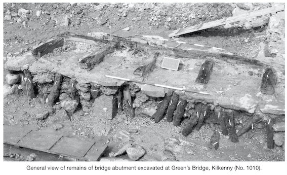
As part of the River Nore (Kilkenny City) Drainage, excavations resumed at Green’s Bridge, some 40m upstream of the existing late 18th-century bridge structure. Previous excavations by Paul Stevens had been carried out in 2001 at this location. They revealed the remains of a stone bridge, believed to have been constructed between 1487 and 1526 and demolished during the flood of 1763, which consisted of five sections of the bridge piers. The piers roughly correspond to the position of the bridge shown on Rocque’s map of 1758. The bridge was constructed on large rectangular ashlar stone piers, which supported stone arches. The foundations of an abutment (the point where the bridge reaches dry land) was revealed on the eastern bank of the river. The abutment was constructed from a series of timber piles supporting a mortared masonry raft (Excavations 2001, No. 699, ‘Pier 3’).
The 2003 excavations were intended to excavate the remains of the eastern abutment, which had been left in situ in 2001 pending a redesign of the flood defences at this location. Accordingly, the 2001 excavation trench was reopened and partially expanded. The earliest deposits exposed consisted of riverine silts and clays which contained occasional sherds of medieval Kilkenny-type pottery and ridge tile. A large roughly cut oak beam was laid on top of these deposits. This beam measured 3.78m north–south by 0.27m in diameter. A timber, which measured 1.25m east–west, lay at right angles to the southern end of this beam. On the eastern or landward side of the large north–south-aligned beam, an area of stones was revealed. This stone deposit measured 3.8m north–south by 0.5m by 0.2m in depth. A series of 24 stakes was also exposed. These formed an irregular north–south alignment measuring 5.2m in length but turned to the east at the northern end of the large beam. In this manner, they appeared to mirror the position of the smaller east–west-aligned beam to the south. The riverbank to the north and east of these timbers was partly revetted by the construction of two separate post-and-wattle fences. These may have been constructed to allow excavation within the footprint of the bridge abutment. Sherds of North Devon ceramics within the associated fill suggest a 17th-century date for these fences.
The bridge abutment was constructed directly on top of the timber beams and associated stone packing. This structure was formed by driving some 37 oak posts into the river gravels to form a three-sided rectangular enclosure. This stake alignment measured some 6.4m north–south by 1.7m and was open on the eastern or landward side. The stakes, of oak, measured between 0.51m and 1.3m in length and had diameters averaging 0.16m. The area enclosed by these posts was filled with a mixture of stones and gravels. Finds from this fill deposit included two clay-pipe bowls spanning the late 17th and early 18th centuries, a sherd of Frechen ware, two sherds of red earthenware and a coin of Elizabeth I from 1602. This fill deposit and the timber posts were used to support a level surface of limestone slabs, which had been bonded firmly into place by a compact reddish-pink mortar. The upper surface of the platform provided by the mortared slabs subsequently had an oak timber structure placed upon it. This timber frame consisted of five roughly squared east–west-aligned beams which were joined at their eastern ends to two north–south-aligned beams by half lap joints. The east–west beams measured between 1.4m and 2.1m in length, while the larger north–south beam measured 3.8m in length. The second north–south-aligned beam, which measured 1.3m, served to continue the length of the longer beam. It was obvious that a north–south-aligned beam had originally been present on the western side of the abutment, as traces of lap joints on the western ends of the east–west-aligned timbers survived. It thus appears that this oak frame structure formed a raft-type foundation for a masonry structure above it. This Green’s Bridge raft frame was subsequently covered with a compact mortar and blocks of masonry.
A masonry wall was subsequently added onto the northern end of the bridge abutment. This wall, which may have been intended to prevent erosion on the upstream side, measured 2.5m north-east/south-west by 0.6m wide by 0.65m in height. A sherd of North Devon pottery was found at the base of this wall.
The 2003 excavations at Green’s Bridge revealed the remains of the eastern abutment of the structure destroyed during the flood of 1763. Details of the foundations uncovered at Green’s Bridge are comparable to those uncovered in 2002 at John’s Bridge, where identical oak rafts were used during the 16th and 17th centuries (Excavations 2002, No. 1026, 01E0980).