2003:2254 - TULLAGH UPPER, Galway
County: Galway
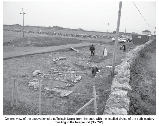
Site name: TULLAGH UPPER
Sites and Monuments Record No.: N/A
Licence number: 03E1344
Author: Martin Jones, National Roads Design Office
Author/Organisation Address: Galway County Council
Site type: Burial ground and House - 18th century
Period/Dating: Modern (AD 1750-AD 2000)
ITM: E 559848m, N 716594m
Latitude, Longitude (decimal degrees): 53.198268, -8.600926
Human skeletal remains were discovered by the boundary wall of a field, adjacent to a local rural road, during the excavation of test-trenches along the route of the proposed N6 Loughrea Bypass and N66 Gort Link. Full excavation of the area was carried out between August and October 2003. Four skeletons were recorded, as well as an early boundary ditch, early road metalling and the remains of an 18thcentury dwelling. These features can be divided into a number of distinct phases.
In Phase 1, a thick metalled surface, formed of compacted gravel and small stones, is interpreted as an early roadway or an earlier alignment of the present road. This road is not now one of the main routes extending westwards from the town of Loughrea but may once have been the principal medieval road from that town to the coast.
In Phase 2, a narrow, V-shaped ditch was cut through the margins of the metalled surface, forming a boundary between the field and the early roadway. The ditch had a maximum width of 1.4m and was up to 0.8m deep.
In Phase 3, a dwelling was erected by the roadside, in the eastern extremity of the excavated area and partly overlying the Phase 2 ditch. This was represented by small lintelled stone drains beneath a floor layer (with possible hearth deposits) of compacted gravel and small stones in a matrix of sandy silt. A small wall remnant, built with undressed field rubble, stood adjacent to the dwelling and may be associated with it. Another lintelled drain lay at the western extremity of the site. This took the form of a central linear channel, 3.8m long and aligned north-west/south-east, with three offshoots of similar construction.
A small quantity of habitation refuse was found. This included shellfish remains, butchered animal bone, modern glass, pottery (including blackware), clay-pipe fragments, ceramic wig curlers, corroded iron artefacts (nails, a horseshoe fragment and a razor or penknife), straight pins, a small portion of a wooden peg, a pewter spoon and a George II halfpenny (in the ‘old head’ style, as described in Colgan 2003, 167).
Four human skeletons were buried within the ditch fill. The skeletons were supine and oriented in the usual Christian manner, but there were neither grave-markers nor coffins. Obviously these postdated Phases 1 and 2 (the early road and boundary ditch). They may have been inhabitants of the dwelling, but it was not possible to establish on stratigraphic grounds that they were closely contemporary with it. Pending the results of radiocarbon dating, they may only be described as probable victims of some episode of famine, war or disease in the post-medieval or early modern period.
Osteological analysis and radiocarbon dating of the human remains, conservation of the metal objects and a comprehensive programme of soil sample analysis is being undertaken. Publication in the Journal of the Galway Archaeological and Historical Society is proposed.
The excavation and analyses were conducted by Galway County Council and funded by the National Roads Authority under the aegis of the National Development Plan 2002–2006.
Reference
Colgan, E. 2003 For want of good money: the story of Ireland’s coinage. Bray.