2003:2158 - SWORDS: Mount Gamble, Townparks, Dublin
County: Dublin
Site name: SWORDS: Mount Gamble, Townparks
Sites and Monuments Record No.: DU011-101----
Licence number: 02E0608
Author: Edmond O’Donovan, Margaret Gowen & Co. Ltd.
Author/Organisation Address: 2 Killiney View, Albert Road Lower, Glenageary, Co. Dublin
Site type: Burial ground
Period/Dating: Multi-period
ITM: E 718252m, N 746494m
Latitude, Longitude (decimal degrees): 53.455225, -6.219469
Swords is best known historically as the resting place of Brian Boru’s body after his death at the battle of Clontarf in AD 1014. His body lay overnight in the church at Swords and later processed to Armagh, where the High King was buried. A round tower and medieval church survive at the site of the Early Christian monastery and a substantial medieval archiepiscopal castle (Swords Castle) is located at the apex of the main street. The medieval village of Swords flourished and the present town has grown around these sites.
An excavation in the summer of 2003 has shed new light on the population of the locality, spanning the Late Iron Age and early medieval period. The site was located on a low hillock overlooking Swords on the southern suburban fringes of the town. This prominent position was later utilised for the site of a previously unrecorded windmill in the medieval period. The site’s name, Mount Gamble, derives from a house built on the site in the 18th century; it was finally demolished in the 1980s when a supermarket carpark was constructed. Local tradition attributes the construction of the house to Sir Robert Molesworth in 1701. No record of any archaeological material or folk tradition relating to burial was known or recorded at Mount Gamble prior to the discovery of human remains during an archaeological assessment of the site (Excavations 2002, No. 686).
The cemetery
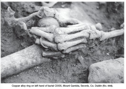
Two hundred and eighty-seven inhumed burials were excavated at Mount Gamble. The cemetery was fully excavated and no enclosure was present around it. It was located at the very top of the hillock radiating 6–8m around the apex of the hill. The burials were up to seven deep at the centre of the cemetery and became less dense towards the ill-defined edge of the site. The majority of the burials were stratified (75%); however, a quarter (25%) of the burials were unassociated and were located predominantly on the fringes of the cemetery. Tradition appears to have denoted the location of the site as opposed to an enclosure, and low grave mounds may have been the only physical presence on the hill identifying the site; however, a single stone-lined post-hole was recorded on the site’s eastern edge. A wooden pillar set in the post-hole may have identified the location of the site, although a timber post would have a limited lifespan. No evidence for a stone or timber church or other building was discovered at the site.
The human osteological (bone) analysis is ongoing and the following information is provisional and based upon field recording only. Adults dominated (67%) the population, juveniles represented a further quarter (25%) and only a small proportion of the population at the site were infants (8%). The population represented in the cemetery appears to have been composed from a broad spectrum of the local sub-population, where all ages and sexes were buried on the hillock. No clear divisions were identified within the cemetery distinguishing between the areas where men or women were buried, but the eastern quadrant contained a greater proportion of infants than the remainder of the site. Clearly there was a tradition of burying young children in this portion of the cemetery; nevertheless, the excavated remains were not consistent with a ‘killeen’.
The grave morphology and body position at burial was not consistent throughout the life of the cemetery. The earliest burials were crouched and flexed, representing 6% of the total population. These burials were all identified at the lowest stratigraphic levels and pre-dated the later extended inhumation burials, representing 50% of the total population. It was not possible to establish the definite body position of 44% of the burials, as successive interment at the site had led to significant disturbance of earlier burials.
The interpretation of the site at the time of writing indicates that the hillock at Mount Gamble was the tribal burial ground for a local population c. AD 500–900; the age range of the cemetery may extend with the results of the radiocarbon dating programme. The period spans the transition from paganism to Christianity. The introduction of ‘Christian’ burial practices is reflected in the change in character of the burial rite from crouched/flexed inhumation to extended inhumation. However, any simplification of the burial rite overlooks the complexity and variety of burial types within both the ‘Christian’ and ‘pagan’ groups uncovered. The range of grave types (simple unlined graves, stone-lined graves and lintel graves) and body positions (hands, legs, head) changed throughout the use of the site.
Amongst the foci for the post-excavation analysis is establishing a chronology of the burial record through the results of the radiocarbon dating programme. It is hoped to propose a relative chronology for the morphology and body position of graves at the site and a critique on the introduction of the sub-Roman burial rite of extended inhumation with the head to the west.
The windmill
The foundation trenches of a timber windmill were discovered 2m from the edge of the cemetery site. The windmill was sited just to the north-west of the apex of the hillock and was identified as two intersecting trenches forming a symmetrical cross.
The foundation trenches were between 8.25 and 9.4m long and between 0.75 and 1m wide and were cut to a depth of 1.31 to 1.38m below the ground surface. The edges of the foundation trenches were straight with a flat base. The morphology of the surviving archaeological feature is very similar to timber windmill sites excavated in medieval and early post-medieval Britain. It appears the windmill required a substantial timber cruciform base plate bedded into the hillside, on which the upper structure pivoted. This allowed the sails of the windmill to be positioned to maximise exposure to the prevailing wind. No other elements of the structure survived, although cereal grains have been identified in soil samples (Penny Johnston, pers. comm.).