2003:2141 - OLDCOURT: Ballycullen (Site 3), Dublin
County: Dublin
Site name: OLDCOURT: Ballycullen (Site 3)
Sites and Monuments Record No.: N/A
Licence number: 02E1473
Author: Ellinor Larsson, for Arch-Tech Ltd.
Author/Organisation Address: 32 Fitzwilliam Place, Dublin 2
Site type: Structure, Habitation site, Enclosure, Cremation pit and Pit
Period/Dating: Prehistoric (12700 BC-AD 400)
ITM: E 711322m, N 726998m
Latitude, Longitude (decimal degrees): 53.281600, -6.330627
The excavation of Ballycullen Site 3 was carried out in September–October 2003. The site was identified in July 2003 during Phase 7 of a programme of monitoring of topsoil-stripping, which was carried out in advance of a residential development (No. 649, Excavations 2003, 02E0190 ext.). Site 3 included six areas, labelled Areas A, B and E–H, situated on the crest of a low but marked ridge in the south part of the development, encompassing an area measuring c. 65m north–south by 100m. Features included a circular structure (Area A), two groups of possible prehistoric features to the west of this (Areas B and E), and two solitary pits on the north-facing slope, possibly cremation pits (Areas G and H). Area F was identified to be of non-archaeological origin. Three derelict field boundary ditches were identified on the ridge truncating Areas A, B and E. These features were disused by the time the first-edition OS map was produced in 1844. Frequent furrow marks were identified throughout the field, cutting into the natural subsoil.
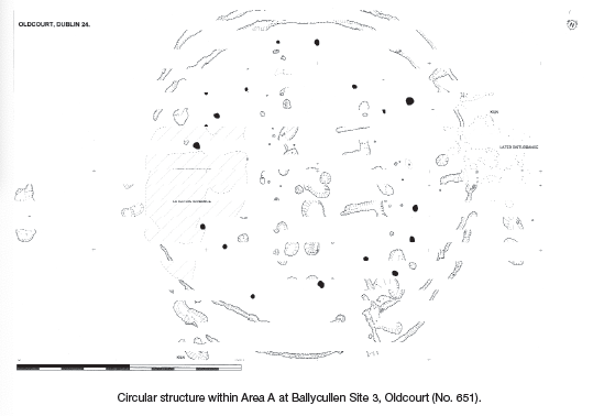
Area A
Area A was situated on even ground at the eastern edge of the ridge and encompassed an area of 30m east–west by 35m. A high density of c. 70 features were identified during initial inspection. The majority were encircled by a thin, curvilinear gully, measuring 14.5m in diameter and forming the pattern of a circular structure. Concentric with the gully was a circle of seventeen post-holes, possibly representing roof-support posts. Two L-shaped internal slot-trenches were situated in the centre of the circle, aligned with the entrance in the east-northeast. The gully is likely to have been inserted to drain excess water rather than to house a wall, suggesting that the internal circle of post-holes constituted the perimeter of the house wall. Several internal pits can be interpreted as fire pits, and others contained finds such as pottery and possible glass slag.
Finds consisted of undecorated coarse pottery of unknown date, three fragments of corroded ferrous objects, possible glass slag and a small assemblage of flint flakes. A fragmentary leaf-shaped flint arrowhead in pressure-flake technique, one core and some pieces of debitage were also recovered from surface cleaning in this area. The structure can be interpreted from its size, shape and finds to be of possible Iron Age date, bearing similarities to Iron Age roundhouses in Britain.
Later strata of archaeological features were identified in the east-north-east part of the structure, partially obscuring the entrance and of unknown date. A large linear anomaly truncated the north end of the site and, on the basis of finds deriving from the fill of this ditch, it was attributed a post-medieval/modern date.
Area B
Area B consisted of c. 25 features and was situated on the ridge c. 15m to the west of Area A, measuring 20m north–south by 15m. The area consisted of features such as post-holes, pits and a cobbled surface, although not forming a distinguishable pattern. The majority of the finds consisted of struck flints, and one thumbnail scraper was found in a pit. A pit and two post-holes situated in the eastern part of Area B can be identified as being of medieval date, as the pit contained Dublin-type pottery, a hone stone and two iron nails. These features were situated directly to the east of the terminal of the large ditch of the derelict field boundary which cuts through Area E.
The majority of the features of Area B can be interpreted as a group of peripheral features associated with Area A.
Area E
Area E was situated on the central part of the ridge and consisted of a large drop-shaped feature measuring 5.1m east–west by 1.5m, two possible post-holes and one small pit. The large feature displayed a charcoal-rich soil with much burnt stone, resembling fulacht fiadh material, and occasional fragments of burnt and unburnt bone. The drop-shaped feature was cut in the north part by a large linear feature, identified as a field boundary ditch, orientated east–west. Upon excavation, a bottle of green glass was found in its base fill. This boundary ditch was situated parallel with a larger linear cut to the south which terminates in Area B to the east. The two ditches appear to constitute the sides of a substantial boundary, between which a field bank had been situated, under which the archaeological features had survived. No finds were found in association with the features, and the date can only be ascertained by analysis of the sampled material, which is ongoing.
Area G
Area G was identified as an irregular charcoal-rich feature, possibly a cremation pit, situated on the north-facing slope of the ridge. The cut measured 0.4m north–south by 0.5m, and 0.22m in depth, and had sharp edges and a concave base. It had three fills, of which the primary was the most substantial and contained frequent charcoal chunks and burnt/partially burnt bone fragments. No finds were retrieved from this feature. The initial conclusion, prior to analysis of the samples, suggests that the pit is a truncated base of a cremation pit. This can only be confirmed through full post-excavation analysis, which is ongoing.
Area H
The feature consisted of an oval cut measuring 0.78m by 0.42m with a depth of 0.07m. The shallow pit had sides that sloped very gradually to a flat base and was situated 27m south-east of Area G. The cut was filled with loose grey ash, with moderate inclusions of charcoal and gravel-sized stones, occasional inclusions of red-burnt clay and very occasional flecks of burnt-bone fragments. A flint flake and occasional small rounded nodules of quartz were found in it. At the base of the pit was a horizontal density of charcoal, a possible plank. In the western corner of the base of the pit was a smaller sub-circular feature, which measured 0.4m in diameter and 0.25m in depth. Its fill contained a high frequency of charcoal and burnt bone. The fill had densely packed charcoal along the edges of the cut, where evidence of scorching was visible. The shape and location of fills suggest that the small cut had truncated the base of the pit and contained the possible cremation, which had been covered by an ashy layer.
Post-excavation analysis is ongoing.