2003:2106 - KILGOBBIN, Dublin
County: Dublin
Site name: KILGOBBIN
Sites and Monuments Record No.: N/A
Licence number: 03E0306
Author: Ines Hagen, Margaret Gowan & Co. Ltd.
Author/Organisation Address: 2 Kiliney View, Albert Road Lower, Co. Dublin
Site type: Kiln - corn-drying, Pit-burial, Habitation site, Pit, House - Neolithic and Structure
Period/Dating: Multi-period
ITM: E 719439m, N 724411m
Latitude, Longitude (decimal degrees): 53.256597, -6.209939
Monitoring of the central portion of the development site at Kilgobbin (Excavations 2002, Nos 605 and 617, Excavations 2003, 02E0906 ext.) revealed eight areas of interest, which were excavated in succession by a team of up to sixteen archaeologists between April and August 2003. A further area, located alongside Kilgobbin Stream, was excavated by Abi Cryerhall (No. 614, Excavations 2003, 03E0717). Post-excavation work is currently in progress and more detailed specialist results and a programme of radiocarbon dating is pending.
The main focus of settlement (Area 6) revealed evidence of Neolithic to Early Bronze Age activity, with some outlying areas being present to the west (Areas 4 and 5), south (Areas 1 and 3) and east (Area 7). Medieval features were found within Areas 0 and 1, while post-medieval evidence was found to truncate earlier features in Areas 1, 2, 3 and 6.
Area 0
Located c. 100m north-west of Kilgobbin Church, this area contained a corn-drying kiln of possible early medieval date. It was keyhole-shaped in plan, oriented east–west, with maximum dimensions of 1.6m by 0.9m by 0.3m deep. It consisted of a roughly circular fire bowl, joined by a subrectangular drying chamber in the west.
Area 1
This site was situated halfway between Enniskerry Road and Kilgobbin Stream at a distance of 75m south of Area 6. Five separate areas were investigated.
The exploration of the vicinity surrounding the findspot of an Early Bronze Age flat axe fragment recovered from the topsoil did not reveal any other activity of this period. A cremation burial, measuring 0.75m by 0.6m by 0.48m deep, was located to the south.
The medieval period was represented by a small truncated pit, which yielded Leinster cooking ware. A kiln, 3.5m by 1.5m by 0.22m deep, may also belong to this period. It consisted of a fire bowl with an elongated flue on its upslope side. Surrounding the fire bowl was a series of stake-holes. These may have supported a timber superstructure over the fire bowl.
A complex of ditches, pits and furrows bear witness to the agricultural activities carried out in the area. A modern calf burial, a rectangular pit containing quarried granite waste and an isolated charcoal spread of uncertain date complete the number of features found within the area.
Area 2
This site was located just 40m north-west of Area 1 and straddled an east–west-oriented field boundary. Located to its north were three small pits, and a shallow curvilinear ditch drained into it on its southern side. Each of the pits contained a small amount of burnt bone, which is currently being analysed.
Area 3
This small area is 30m south of Area 6. It contained a small north–south-oriented pit, which measured 1.52m by 0.5–0.8m wide and 0.1–0.2m deep. It was severely truncated by a post-medieval furrow. One of its fills yielded a sherd of Beaker pottery.
Area 4
Like Area 3, this site was near Area 6 and is related to that activity. Three small pits, which possibly functioned as refuse pits associated with the nearby settlement, were found within the area. None of their fills contained finds.
Area 5
Two pits of Bronze Age date were found within this area. The larger was shallow, irregularly shaped, with maximum dimensions of 2.5m by 2.25m by 0.22m deep. Its sides were shallow and uneven, as was the base. Its single fill yielded one sherd of Beaker pottery, a flint flake and a small flint barbed-and-tanged arrowhead.
Oriented north-east/south-west, the second pit lay 0.5m from the former. It was sub-circular in plan and measured 1.6m by 1.1m by 0.45m deep. The cut had steep concave sides and a relatively flat base. The remains of a single deposit were found covering the base and sides of the cut. This was subsequently recut by a second pit, which measured 0.9m by 0.8m by 0.36m deep. Two fills, both of which yielded finds of Bronze Age date, were contained within this cut.
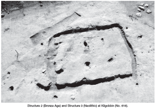
Area 6
This site represented the largest area investigated and contained the main concentration of prehistoric activity. It measured 90m east–west by 60m and was located 60m south of Kilgobbin Stream on relatively flat ground. Three main structures were identified, a Neolithic house (Structure 3) and two Bronze Age structures (Structures 1 and 2). No medieval activity was present within the site. A variety of postmedieval features, such as land drains, plough furrows and pits, have contributed to the truncation of prehistoric features.
The remains of a rectangular house, Structure 3, were uncovered at the southern limits of Area 6. It was aligned roughly east–west and had overall dimensions of 9m east–west by 7m. It was defined by a continuous foundation trench, 0.5–0.7m wide and up to 0.5m deep. The east wall was slightly shallower and measured up to 1m wide at its southern side. The east and west walls were slightly curved. This trench contained the plank footing along its internal side, which averaged 0.3m deep. Below this and along the external sides, packing stones and redeposited soil were used to support the plank-built walls. A gap in this plank footing along the northern side of the east wall was interpreted as the entrance. It was flanked on either side by a post. Except in the south-east, a structural post was found at each of the rounded corners of the house. While no internal floor surface survived, the possible remains of a hearth were found at its approximate centre. Five internal roof supports were present, dividing the internal space into three areas. Several external posts, a stony surface and a possible fence were also found associated with the house. The remains of this house were truncated in the post-medieval period by plough furrows and a large open drain, the latter cutting the south-eastern corner of the house. Finds consisted of sherds of pottery and flint, the latter including a leaf-shaped arrowhead. Other features of Neolithic date were found distributed throughout the area and included a number of refuse pits.
An area of intense activity was present within the north-western quadrant of the area, which included a small circular structure, a large pit of Beaker date and a further collection of associated pits and post-holes.
Structure 1 was a small structure defined by a circle of post-holes measuring 3m in diameter. No artefacts were associated with this structure, but it is thought to be associated with a large structure to the south-east and a refuse pit to the north-east. A series of additional post-holes and pits, including a cremation burial, was found near it.
Two charcoal-rich deposits were found spread over an area measuring 4.2m north-east/south-west by 1.1–2.2m. They filled and spread over an irregular-shaped pit (1.8m east–west by 1.4m) located at its northern end. Nearly 1400 finds were retrieved from these deposits, representing over half the finds from the entire excavation. Underlying the main Beaker-yielding deposits was a layer of burnt soil mixed with charcoal, which was present throughout most of the length of the spread. This, in turn, overlay a layer of relatively sterile material found only at the base of the pit. Several stake-holes were revealed near these deposits, which are interpreted as evidence of an associated timber superstructure. These comprised a semicircular arrangement along its south-western side, and two parallel lines of stakes to the north-west and south-east.
Structure 2, a large circular structure 10m in overall diameter, was situated at the centre of the area. It was defined by a foundation trench, which was generally 0.5m wide and 0.3m deep. A series of post-holes formed the wall of the structure. Several posts found near the internal and external sides of the trench are associated with this. A multitude of stake-holes and pits were present inside the structure, but neither a hearth nor an original floor surface survived. Two large posts, placed at a distance of 2m apart, formed the entrance at the northern side. Finds from the foundation trench and associated features were few and consisted mainly of small, abraded sherds of Beaker pottery. A variety of additional pits were revealed in the general vicinity, as well as a concentration of post-holes located just to the south-east of the structure.
The construction of the foundation trench postdates a curvilinear ditch located in the west and a compacted spread of material, both of which yielded Beaker pottery. The spread, interpreted as an old ground surface, extended for 27m in a northwest/ south-east direction and was partially present within the interior of the structure.
The site was severely truncated by post-medieval agricultural activity. East–west-running plough furrows were present throughout the site and a north–south-oriented land drain cut through the eastern third of the structure. East of this drain, the foundation trench was less well preserved and had been entirely removed in the north-eastern quadrant by activity associated with the construction of the land drain.
Area 7
Located 60m south-east of Area 6 on relatively level ground, this site consisted of a pit filled with charcoal-rich soil and burnt stone. This feature had been badly disturbed by recent machinery tracks prior to topsoil removal. The pit was roughly rectangular in plan, oriented north-west/south-east, and measured 1.8m by 1.35m by 0.02–0.1m deep. It may be associated with the Bronze Age activity excavated adjacent to Kilgobbin Stream.
Conclusion
The excavations carried out to date contribute to an increasingly complex pattern of settlement in south County Dublin during the Neolithic and Beaker periods. The first evidence of earlier prehistoric occupation uncovered at Dalkey Island has been significantly increased in recent years by findings from excavations along the South-Eastern Motorway, at locations such as Matthew Seaver and Valerie Keeley’s site at Laughaunstown (Excavations 2001, No. 442, 00E0283) and Mark Clinton’s site at Carrickmines (ibid., No. 335, 00E0525). Excavations carried out by Arch-Tech Ltd to the north of Kilgobbin Stream have also found evidence of Bronze Age habitation and burial (Stephen Johnston, pers.
comm.).