2003:443 - DUNNYNEIL ISLAND, Strangford Lough, Down
County: Down
Site name: DUNNYNEIL ISLAND, Strangford Lough
Sites and Monuments Record No.: DOW024-035
Licence number: AE/03/71
Author: Finbar McCormick and Philip Macdonald, School of Archaeology and Palaeoecology
Author/Organisation Address: Queen’s University, Belfast BT7 1NN
Site type: Habitation site, Ringfort - rath and Enclosure
Period/Dating: Multi-period
ITM: E 754646m, N 853871m
Latitude, Longitude (decimal degrees): 54.409889, -5.617611
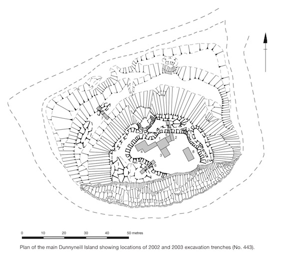
Following a topographic survey and limited excavations in 2002 (Excavations 2002, No. 441, AE/02/90), a second season of excavations was conducted on the larger Dunnyneill Island during August and September 2003. The Dunnyneill Islands lie in Strangford Lough, 2.5km to the north-east of Killyleagh. They consist of a larger and a smaller island, linked by a causeway at low tide, which are strategically located so as to command the narrows at the Lough’s mouth and the entrance to the Quoile Estuary. The highest point of the larger island consists of a flat plateau surrounded by a subcircular enclosure, defined by a counter-scarped bank, ditch and inner bank, augmented by a smaller annexed enclosure defined by a ditch and located on a slightly lower terrace. In addition to the main enclosure and annexe at the top of the island, a low earthwork, now interrupted and disturbed by a series of hollows marking later activity, apparently enclosed the base of the hill just above the high-tide line.
In addition to the two trenches which were opened in 2002, a further six trenches were excavated during 2003. The combined excavations revealed evidence for two main phases of activity. The earlier phase was associated with the construction of the enclosing earthworks and several occupational features, including a curvilinear wall footing for a structure which had an estimated external diameter of c. 8m. The later phase was associated with the deliberate slighting of the inner bank and the deposition of levelling deposits partially made up of beach gravel.
Animal bone from two separate contexts was submitted for dating to the Radiocarbon Dating Laboratory, Queen’s University, Belfast. The results obtained were as follows: UB-4918 (animal bone) Context No. 102, 1195±22 BP, 1 sigma cal. AD 786–883, 2 sigma cal. AD 775–889: UB-4919 (animal bone) Context No. 205, 1292±20 BP, 1 sigma cal. AD 674–759, 2 sigma cal. AD 666–775.
The first date (UB-4918) is based on material recovered from a superficial context. However, the animal bone used for the second date (UB-4919) was derived from the primary fill of the enclosing ditch and suggests an early medieval date for the early phase. Artefactually, this early phase is most clearly represented by three sherds of E ware, dated to the late 6th or 7th century, which were recovered from an upper ditch fill. Other finds dating to this phase include an assemblage of apparently imported glass, worked bone and evidence for either glass or metalworking. The recognition of imported ceramics, combined with the evidence for craft activity on the island, suggested that the site might have had a special status in the early medieval period associated with a range of craft and trade activities. Dating evidence for the second phase is provided by a large assemblage of cordoned souterrain ware, a copper alloy buckle of late 12th- to late 14th-century date and a copper alloy stud-headed stick pin which may date, by analogy with examples from Waterford, from the mid-11th to early 13th century. This material was recovered from either superficial contexts or the slighted bank and levelling deposits. No structural evidence dating to the later phase was identified during the excavation. A significant number of prehistoric flints and a small amount of prehistoric pottery were also recovered; however, no demonstrably prehistoric contexts were identified and it is probable that this evidence of prehistoric activity on the island survives only as residually deposited artefactual material.