2002:1623 - ROSCOMMON: Civic Offices, Roscommon
County: Roscommon
Site name: ROSCOMMON: Civic Offices
Sites and Monuments Record No.: N/A
Licence number: 02E1555
Author: Donald Murphy, ACS Ltd.
Author/Organisation Address: Unit 21, Boyne Business Park, Greenhills, Drogheda, Co. Louth
Site type: Prison
Period/Dating: Modern (AD 1750-AD 2000)
ITM: E 587491m, N 764214m
Latitude, Longitude (decimal degrees): 53.627591, -8.189096
Roscommon County Council is considering the development of the gaol site into new civic offices. The site incorporates its current offices and is used as a store and supplies yard and for car-parking for the County Council and the courthouse. An underground carpark is being considered as part of the development.
Roscommon town has had at least two historical gaols. The first possibly originated in the first half of the 18th century and is referred to here, as in other sources, as the ‘old gaol’, and the more recent, 19th-century structure is referred to simply as the ‘gaol’. The latter building is the gaol investigated as part of this assessment. The old gaol at The Market between Castle Street and Main Street was most likely built in the late 1730s and apparently replaced an even older gaol situated on Abbey Street. Sometime before 1829, the old gaol had fallen out of use as a prison and instead served as a lunatic asylum (Weld 1832). Later, Lewis (1837) noted that the old gaol was in use as a market house.
In 1819 the land on which the new gaol was built was purchased for £1846 3s. 1d. (Irish Builder, 1 August 1882). The site of the gaol and the adjacent courthouse was ‘an extensive flat space…purposely levelled to receive the whole, on the western side of the hill and close to its brow’ (Weld 1832). In 1824 the Inspector General of Prisons in Ireland described the gaol as having been built on a semicircular plan. The gaol consisted of eight divisions with yards, workrooms, a chapel, a hospital and 91 sleeping cells. A matron and a schoolmaster were employed, along with the prison governor, and the gaol was run efficiently by a board of superintendents, who ensured that it was kept ‘in a very creditable state of cleanliness’. In 1829, however, when the Inspector revisited the gaol, he was critical of prison discipline (ibid.).
It appears, based on this evidence, that the new gaol must have been completed between 1819 and 1824. Lewis’s (1837) description gives a similar detailed account of the gaol, which may have been built in conjunction with the new courthouse: ‘near it [the courthouse] is the new gaol for the county, built upon the radiating principle and of polygonal form, containing eight wards, with airing yards and work-rooms, and 91 sleeping cells, an hospital, a chapel, school and tread-wheel’. The 1837–8 6-inch OS map appears to confirm this.
Although plans were drawn up for a new courthouse as early as 1762, it is apparent that the adjacent courthouse was built at a later time, as Weld states that on his visit in 1830 the courthouse, which had ‘been latterly erected’, was not entirely complete (ibid.). It is also apparent that the courthouse, like the gaol, replaced an earlier building, known as the Sessions House (Pakenham–Mahon papers, NLI MS 10,770).
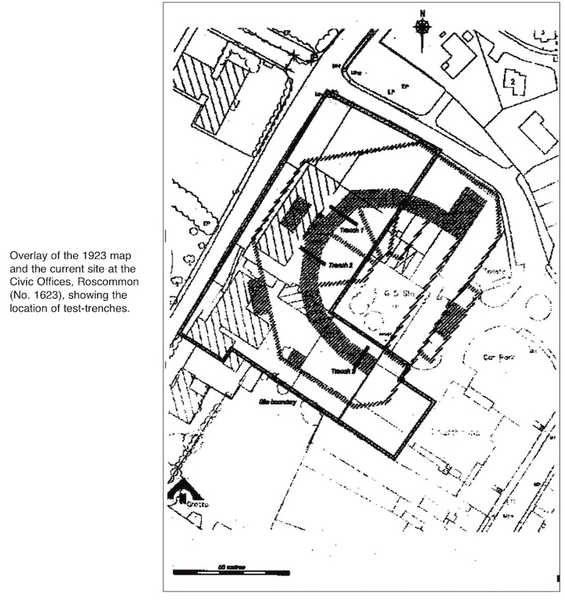
Roscommon Gaol is depicted to the north-west of the courthouse on the 1837–8 6-inch OS map, The straight side of the gaol is shown facing south-east, which is in accordance with later maps. All eight wards are clearly visible, along with the outer walls, the main gate (in the south-east wall) and four internal structures.
By the time of the publication of the 1891–2 5ft-scale OS map, the three southernmost wards had been converted to an open-plan area with access via the south-east corner to an outer yard. An extra wall with integral door had been built at the west side of the grounds of the gaol, running from north-north-west to south-south-east. In addition to the structures noted on the 1837–8 map, six other possible structures are discernible on the 1891–2 map, of which one is noted as a chimney. Adjacent to the existing prison gate, a smaller gate has been inserted. Significantly, the tunnel linking the gaol to the courthouse is shown running in a straight line from the north-west side of the courthouse to the south-east side of the gaol. Steps are depicted leading down to the tunnel on the inside of the south-eastern outer wall of the gaol. Being on 5ft scale, this map gives a more accurate plan of the structure. Whereas on the 1837–8 map the gaol appears as a semicircle, albeit with radials, the 1891–2 map depicts the angular facets of the polygonal structure with some detail.
The gaol appears to be unchanged between the times of the 1891 and 1923 maps, although it is marked as a ‘Military Barracks’ on the latter edition. It was, therefore, between these years that the structure fell out of use as a prison.
The trenches excavated on the site confirmed that significant remains of the 19th-century gaol survive almost directly below the carpark and yard surfaces. The remains uncovered were aligned perfectly with the building shown on the various editions of the OS maps and consisted of the walls and floor of the rotunda building that housed the inmates. Doorways exposed in two of the trenches probably represent doors to the cells, to which access from the warden’s building was gained via the various segmented yards. The walls and floor surfaces rested directly on natural boulder clay. The lack of stratigraphy is not surprising, given that the site is recorded as having been lowered before construction work started on the gaol between 1819 and 1824. In addition to the remains of the rotunda building, two upstanding parts of the perimeter wall and the subway from the courthouse to the gaol yard survive.
As the local authority is only carrying out a feasibility study into the suitability of the site for development, no detailed plans are available. The outline proposal, however, is for an underground or basement carpark. This will result in the total removal of the foundation and floor remains of the gaol. Even if the idea of a basement carpark is abandoned, the impact of any foundation structure and new service ducts etc. on the remains will be quite high, as the level of cover is minimal (0.2m). Preservation in situ is not considered to be appropriate because of this minimum cover and the unknown impact of any foundation structure on areas not tested. A full archaeological excavation is necessary before any development in order to define the full extent of this former public building.
References
Lewis, S. 1837 Topographical dictionary of Ireland. London.
Weld, I. 1832 Statistical survey of the county of Roscommon. Dublin.