2002:1489 - NINCH, Laytown, Meath
County: Meath
Site name: NINCH, Laytown
Sites and Monuments Record No.: N/A
Licence number: 98E0501 ext.
Author: Cia McConway, ADS Ltd.
Author/Organisation Address: Unit 48, Westlink Enterprise Centre, 30–50 Distillery Street, Belfast
Site type: Enclosure, Ringfort - rath, Burial ground, Souterrain, Pit
Period/Dating: —
ITM: E 715986m, N 772162m
Latitude, Longitude (decimal degrees): 53.686288, -6.244042
Excavations of Phase 2 at the Inse Bay Development, Ninch, Laytown, Co. Meath, have uncovered an extensive and multi-phased complex site. In general the site can be dated to the Early Christian period, but there is also evidence of a temporary Neolithic campsite and early medieval kilns and occupation. The northern half of the site consisted of four large, subcircular, roughly concentric but not contemporaneous defensive ditches dating to around the 6th–10th centuries. In addition to these were an Early Christian graveyard, five oval enclosures, which have been interpreted as animal enclosures, circular house slots and cobbled surfaces of c. 8th–10th-century date, two souterrains, a well/fishpond and pits, and slots and gullies that date to around the 11th century. Along the southern half of the site there was evidence of a temporary Late Neolithic campsite, Early Christian ring-ditches and house slots, three subrectangular defensive enclosures dating to around the 11th/12th century and two kilns of c. 13th-century date.
The northern half of the site appeared to have been predominantly a secular, multi-phased rath, perhaps even a tuath of the Ciannachta, and it was perhaps because of the importance of the site that its function changed in the later stages to a ecclesiastical centre. There are strong parallels to the Millockstown site in County Louth, which also has a secular ringfort that was reused as an ecclesiastical site in and around the 8th/9th century.
Later, the southern half of the site was the focus of a series of defensive subrectangular enclosures, a site type not indigenous to Ireland. A Hiberno-Norse ring-pin has dated this phase to the later 10th/early 11th century. Whether the subrectangular enclosures represent an invading people or the adoption by the native Irish of a different site type, they illustrate the return of the site to a secular function. A summary of the excavations of the southern half of the site has been published in Excavations 2001 (No. 1007).
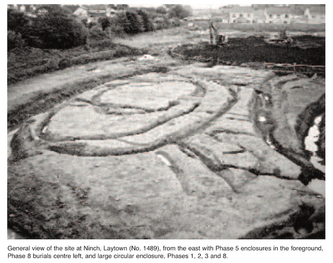
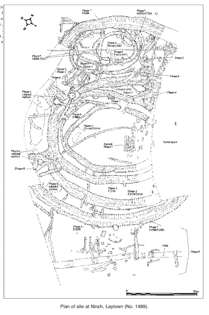
The archaeology of the northern half of the site can be divided into nine distinct phases of activity, although many of these phases can be subdivided. There was no surviving evidence of a bank associated with any of the ditches, although it should be assumed that they had originally existed and were most probably defensive earthworks lying along the inner edge of the ditches. The southern edges of all four large enclosures and the northern edge of the largest enclosure, F4200, ran into unexcavated green spaces and will be preserved in situ.
Phase 1 saw the construction of several linear and curvilinear ditches culminating in an oval ditch, F3449, and its recut, F3010, which enclosed the highest part of the site. Both ditches measured 38m north–south by 25m, and both used the same entrance, 1.5m wide, to the east; however, the recut had a second entrance opposite this, to the west. F3010 was filled with redeposited subsoil, probably bank material, to facilitate the construction of the second large enclosure, F3145.
Phase 2 is essentially defined by the construction of a second large subcircular enclosing ditch, F3145, with extant internal dimensions of 34m east–west by 39m (projected dimension of 46m). It completely enclosed F3449/F3010 and cut through another ditch associated with Phase 1. F3145 was filled with thin bands of friable, red/orange, ash-like deposits, charcoal-rich bands, and loose clays and sands. Several pits with fills identical to this were found outside the ditch to the east and south, suggesting that contemporaneous activity, probably industrial, took place beyond the relative safety of the enclosure. A large quantity of animal bone and shell was recovered from the ditch fills, as were metal slag and several sherds of E-ware pottery. 14C dates are not yet available, but the pottery suggests a date no earlier than the early to mid-7th century for the filling of the ditch. This enclosure was a single-phase construction and was generally narrower and shallower along the eastern side, 3.5m by 1.4m, than the western, 3.8m by 2.1m; it was generally V-shaped in profile. Several burials (Phase 7) cut through the upper fills of this ditch along the east.
Phase 3 is a complicated sequence of events, especially in the south-eastern area of the site. It includes the third large enclosing ditch, F3538, and its recut, F3146, and can be subdivided into six phases of discrete pockets of archaeological activity.
F3538/3146 enclosed the two large ditches described above and partially obliterated the northern edge of F3145. It enclosed an area measuring 50m east–west by 43m and continued into an unexcavated green area to the south. It had quite steep sides and a V-shaped base and was filled with a series of sandy/silty clays with a high gravel content, which was presumably slipped bank material. It was extensively removed by the construction of the souterrain, F3006 (Phase 8), to the north.
The enclosure increased dramatically in width and depth from the east (c. 2m by 0.7m) to the west (4.8m by 1.8m), probably owing to the stratigraphy of the subsoil, which was prone to collapse along the east. The smaller, eastern ditch may have been compensated for by a larger, associated bank using subsoil from the western section.
The three enclosures described above have been interpreted as substantial raths and would have enclosed houses, workshops, hearths and probably animal pens.
However, the communal interior of these enclosures was completely devoid of archaeological activity directly associated with Phases 1–3. This is likely to have been due to the extensive deep ploughing along the crest of the ridge, which demarcated the interior.
Phase 4 indicates a significant change in the nature and function of the site. The large ditched enclosures were abandoned and filled, and in their stead was an unenclosed settlement site consisting of circular houses, 6.5–7m in diameter, slots, gullies and cobbled pathways. This activity was primarily situated to the north and along the eastern slope and was probably associated with the archaeology described in Phase 2 along the southern half of the site (Excavations 2001, No. 1007), which had similarly sized house slots.
Six separate areas of cobbling were uncovered and have been interpreted as originally forming a single stretch, 48m long. Its location, apparently leading up to the annexe of House 3, suggests that it functioned as a formal trackway running east–west along the northern limit of the site. These metalled surfaces were constructed primarily from small beach-rolled stones and almost entirely directly overlay subsoil.
After House 3 fell into disuse, the immediate area was criss-crossed primarily by a complex series of short linear slots and gullies with no surviving associated bank.
Phase 5 describes a series of five oval enclosures, F4874/F4977, F5327/F6666, F4909/F5782, F3151/ F6427 and F3234/F6291, situated along the eastern slope of the site, between the third and the fourth large enclosures, F3538/F3146 and F4200. The ditches post-date the houses assigned to Phase 4 and often recut part of the line of an earlier enclosure. They were similar to the four large enclosures, F3010, F3145, F3146 and F4200, in that no two were contemporaneous, they increased in enclosed area with time and there was no surviving evidence of a bank associated with any of them. All five post-date the three large enclosures described above and pre-date the fourth, F4200, described below.
F4874/F4977 was the earliest and the smallest of the oval enclosures, measuring 16m by 10.5m, and the latest and largest ditch, F3234/F6291, which was truncated by F4200 to the east, measured 30.4m by 22.5m (projected). All five enclosures were oriented north-west/south-east. Four had formal entrance-ways, upslope along their western edges, suggesting contemporaneous activity to the west.
The widths and depths of these oval enclosures suggest that they were not defensive in nature, as does their location downslope. There was no evidence to suggest that they had enclosed houses, slots, pits, post-holes or hearths, and, apart from F5278 (which has been interpreted as the result of continuous trample through the entranceway of the three earliest enclosures), none of the features were contemporary with the ditches that enclosed them. It is likely, then, that the oval enclosures functioned as animal enclosures, presumably with an associated settlement upslope to the west. The re-establishment of these enclosures suggests longevity of the associated settlement. Unfortunately no evidence of such a settlement was uncovered in the area of the excavation.
Phase 6 describes the archaeology that post-dated either Phase 4 or Phase 5 and pre-dated Phase 7 but cannot be directly associated with the oval enclosures of Phase 5. Four pockets of activity are assigned to this phase, and, although each describes a sequence of events, there is no direct stratigraphic relationship between the areas. In general these features consist of gullies, slots and ditches producing charcoal, crushed shell and animal bone. A fourth house, F4613, also belongs to this phase. This house was much bigger than the others, 8.5m in diameter, and, like the others, was not associated with an enclosing ditch.
During Phase 7 the nature and function of the site changed from an unenclosed settlement to an enclosed ecclesiastical site with burial-ground. The fourth and largest of the circular enclosures, F4200, occupied an area measuring 80m east–west by 80m (projected) and fully enclosed all of the archaeology described above. This ditch cut through archaeology associated with Phases 4–6 and was in turn cut by small pits and a small souterrain assigned to Phase 8. This was a massive earthwork, almost 5m wide and 2m deep. A recut, F1368, was identified along the western half of the ditch, up to 4.4m wide and 1.5m deep. Being downslope, the eastern section of the ditch was permanently flooded during excavation, resulting in some organics, including a barrel hoop, being recovered from the fills. It is likely that the continuous silting here necessitated a massive clean-out, effectively obliterating the original ditch cut.
There was no evidence of an upstanding bank associated with this ditch; however, redeposited subsoil that sealed the cobbled surfaces described above in Phase 4 was probably the basal material of the bank. Likewise, the eastern area of the site was sealed with a black sandy soil that has been interpreted as the original ground surface and then sealed with material cast up for the bank.
A number of burials were revealed at the midpoint of the area enclosed by this ditch. E-ware pottery was found associated with both the burials and the ditch, and their location with respect to one another suggests that they are contemporaneous. This has parallels with Millockstown, Co. Meath, where a rath was superseded by a large enclosure containing lintel graves.
A total of 79 burials and a further thirteen disarticulated burials were excavated. Most of the burials lay in an area of 7m by 4.5m, suggesting that they were enclosed, and two burials in well-constructed lintel graves lay to the west of these. Although no evidence of this survived, the plan of the burials and their density here suggest that they had lain in a small wooden church. The remainder of the burials, apart from the two described above, lay to the east and south of this concentration. Most were in simple subsoil-cut graves, with no lining or coffin. There were a few stone-lined graves, some of which were intact and had capping stones covering the burial, but others had been reused, resulting in part of the stone lining being disturbed.
Most of the burials were oriented slightly north-west/south-east, with the head to the west. Most of the remainder were oriented west–east. However, three burials had slight south-west/north-east orientations. All of the burials except one were supine; however, one poorly preserved and disturbed burial, F6946, found in an oval subsoil-cut grave, appeared to be in a crouched position.
All of the skeletons from the 2001–2 season were examined in situ by osteoarchaeologist Laureen Buckley, and a number of pathological lesions were noted. Although these will require further analysis, at least three of the individuals examined showed signs of osteoarthritis, two in the vertebrae, and the third in the left shoulder and hip. Two individuals had osteophytosis of the lumbar vertebrae, and three to four of the thoracic vertebrae of another individual were collapsed and fused, possibly indicating tuberculosis.
Two souterrains and a large pit, interpreted as either a well or a fishpond, can be assigned to Phase 8. The pit was in the south-eastern area of the site and cut through the old ground surface, identified above, that had been sealed by the bank associated with the fourth circular enclosure, F4200. It was 7.5m in diameter and 0.6m deep and was filled with a series of heavy, grey, gritty clays with large, heavy boulders throughout. A subcircular stone setting was uncovered at the base of the pit. Throughout the excavation the pit filled with salt water, making it more likely to have been used as a fishpond than as a well.
Two souterrains were excavated on the site. The larger, F3006, cut through a junction of ditches associated with Phases 1–4 and 6 to the north of the site, and the smaller, F4158, cut through the inner edge and upper fills of F4200. It is assumed that the two souterrains were contemporaneous; however, the larger souterrain had no direct stratigraphic relationship with F4200. Its position in the area that would have been occupied by the bank associated with F4200 may suggest that it was strategically placed in order to use the bank as cover for its chambers. This would suggest that, although the larger souterrain technically post-dated the ditch, it was in use during the lifetime of the ecclesiastical site.
Phase 9 covers the western area of the site. Lying to the west of F4200 was an area of c. 50m by 25m in which lay a series of slots, gullies and pits and a north–south linear ditch, F580. These all lay outside the circular enclosures and had no direct stratigraphic relationship with any of the phases described above. In the absence of 14C dates, it is suggested that the features here are contemporaneous, and the finds recovered from the fills indicate that they may be prehistoric and therefore contemporary with Phase 1 along the southern half of the site. Pottery from a small pit has been identified as Bronze Age (A. Brindley, pers. comm.), and animal bone recovered from ditch F580 appears to be too small for the standard Early Christian dimensions (J. Hughes, pers. comm.). This appears to have parallels with the Colp site, excavated by Donald Murphy, where a linear ditch was bounded a series of prehistoric pits (Excavations 2000, No. 748, 99E0472).