2002:1471 - JOHNSTOWN 1 (Site A), Meath
County: Meath
Site name: JOHNSTOWN 1 (Site A)
Sites and Monuments Record No.: N/A
Licence number: 02E0462
Author: Linda Clarke, ACS Ltd.
Author/Organisation Address: Unit 21, Boyne Business Park, Greenhills, Drogheda, Co. Louth
Site type: Enclosure, Children
Period/Dating: Medieval (AD 400-AD 1600)
ITM: E 688869m, N 766281m
Latitude, Longitude (decimal degrees): 53.406181, -6.832499
This site, south-west of the town of Enfield, on the Edenderry Road, was excavated on behalf of Westmeath County Council, funded by the National Roads Authority, before the construction of the M4 Kinnegad–Enfield–Kilcock Motorway Scheme. The site had been identified during a paper survey as an oval or subrectangular level area slightly higher than the land to the north and west, defined on the east by a low ridge, 3m wide and 30m long. It was known locally as a cillín, a burial-ground normally used for unbaptised children. The site is known as Scaruppa (J. Daly, pers. comm.).
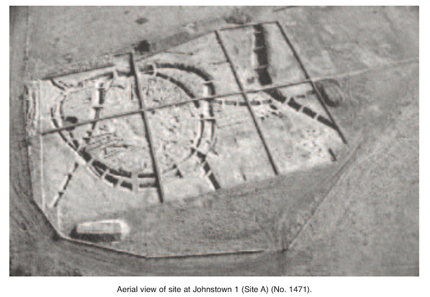
A geophysical survey was carried out from 21 to 30 January 2002. This detected a large, double-ditched enclosure on the flat top of a low rise in the middle of the field. The enclosure was c. 20m north-west of the area known locally as the cillín. The survey also showed the position of several former field boundaries and the remains of heavy ploughing (burials cannot easily be detected by geophysics). The site was assessed by opening four test-trenches within it. These confirmed the presence of all of the cut features (i.e. enclosure ditches) that had been identified in the aerial and geophysical survey and the presence of burials.
The burials exposed during the assessment were not situated in the area traditionally identified as the cillín but were contained in the enclosures identified through aerial photography and geophysics and in test-trenches opened c. 20m to the north-west.
A large-scale excavation with a team of 40–60 people was carried out from 22 April to 11 October 2002. This revealed it to be an extensive settlement site that had been reused intermittently as a burial site. There was no evidence of a church or similar structures, so it cannot be interpreted as an ecclesiastical site. The enclosures exposed in this site represented three phases of activity.
Phase 1
This enclosure had an approximate diameter of 60m and a small, shallow, U-shaped ditch with a maximum width of 2m and a maximum depth of 0.8m. This enclosure ditch was cut by the enclosure ditch that represented Phase 2 to the north-west and the enclosure ditch that represented Phase 3. A large part of the Phase 1 enclosure ditch was visible only in the base of the Phase 3 ditch, and therefore the exact shape and extent of this feature were difficult to establish. A small entrance, 3.2m wide, was visible in this enclosure to the north.
Phase 2
This enclosure was sub-oval and had a maximum diameter of 57m. The ditch was U-shaped in profile, with a maximum depth of 1.1m and a maximum width of 2.5m. It cut the earlier, Phase 1 ditch to the north-west and was cut by the later, Phase 3 ditch to the north-west and north-east. Two entrances were identified in this enclosure: one to the north, with a maximum width of 1.4m, and another to the south-east, with a maximum width of 3.4m.
Phase 3
This enclosure was D-shaped and had a maximum diameter of 60m. The ditch was U-shaped in profile, with a maximum depth of 1.8m and a maximum width of 5.3m. This ditch cut the Phase 1 and Phase 2 ditches. No entrance was identified, although there was a significant rise in the base of the ditch to the north-east that could be interpreted as an entrance.
Two separate burial-grounds were also identified in this site. Most of the burials were contained within the Phase 3 enclosure. A total of 424 burials were exposed in this area, the vast majority in all likelihood early medieval. This assessment can be made based on the alignment of the burials (most of which were string burials and aligned roughly east–west) and on the wear on the teeth. This area was also probably used as a burial-ground intermittently up until pre-Famine times. Two burials were recovered from the base of the enclosure ditch, which suggests that this ditch was open and in use at the same time as the burial-ground.
Most of the burials exposed had no associated finds. Fragments of slag were obtained from the grave fill of a very small minority of graves, and a single decorated bone bead and tiny fragments of a decorated bone comb were recovered from two graves.
The second burial-ground was in the area known locally as ‘Scaruppa’ (a gravel bank, 3m wide and 30m long). This area was traditionally known as the location of the cillín. These burials were recovered from the area immediately north-west and north-east of the gravel bank and from the gravel bank itself. The burials exposed north and north-west of the bank were contained in a large ditch, the function of which is as yet unclear. This feature spanned the width of the road (c. 85m) and extended beyond the road-take, with a maximum width of 6.9m and a maximum depth of 2.7m. A total of 61 baby burials and two adult burials were exposed here. Shroud-pins were recovered from most of the baby burials, which suggests that they were of a much later date (100–200 years ago) than the burials found in the enclosures. Nails (in some cases up to 30) and traces of timber were also recovered in association with these burials, which suggests that they were contained in coffins.
No structures were exposed in the site, but settlement evidence in the form of refuse pits and smelting pits was identified. Approximately 2 tonnes of waste slag and furnace bottom was recovered (most from ditch fill and a working surface that sealed the Phase 3 ditch), which suggests that this was an important industrial site. Most of the finds were recovered from the ditch fill, including rotary-quern fragments, bone pins, metal pins (including a highly decorated ring-pin), shroud-pins, a bone needle, bone, glass and stone beads, pottery fragments (most of which were North Leinster cooking ware), knife blades, loom-weights and coins. Animal bone, butchered bone and cremated bone were also recovered.
A large timber structure (the exact function of which is unclear) was exposed at the base of a large ditch immediately north and north-west of the gravel bank. This feature was a wedge-shaped, plank-built, trough-like structure that measured 3m by 1.5m and survived to a maximum height of 0.4m. A stone loom-weight and animal bone were recovered from its fill. The exact function of this timber structure is unknown, but it is interpreted as a cesspit (refuse and waste) or a type of water-management feature.