2002:1382 - CARROWKEEL, Mayo
County: Mayo
Site name: CARROWKEEL
Sites and Monuments Record No.: SMR 38:4
Licence number: 02E0598
Author: Sue Zajac
Author/Organisation Address: 1 Chapel Lane, Killala, Co. Mayo
Site type: Ringfort - rath, Hut site, Children’s burial ground and Enclosure
Period/Dating: Multi-period
ITM: E 509670m, N 817109m
Latitude, Longitude (decimal degrees): 54.095139, -9.380918
Excavations at Carrowkeel were undertaken on behalf of Mayo County Council before road realignment.
Ringfort
The ringfort is on a low rise with a southerly aspect overlooking Nephin Mountain at c. 55m OD. Before excavation it was seen as a subcircular area defined at the south by a steep-sided scarp. The site was overlain by a field boundary along its eastern edge and by the N59 at the north. The western limits of the ringfort appeared low and degraded. The north-eastern corner had been significantly altered in the recent past by the construction of a small stone stable, and a water main cut through the ringfort. The internal dimensions of the site were 26m north–south by 23m.
Only the northern half of the site was excavated, measuring 13.5m north–south by 43m.
The interior of the ringfort had been disturbed by modern activity and by cultivation furrows that had destroyed any occupation material. A stone spindle-whorl and an assemblage of well-finished chert and flint tools were found in disturbed soil horizons.
A poorly preserved entrance feature lay in the eastern quadrant of the interior, and below the disturbance in the northern quadrant were the remains of a children’s burial-ground.
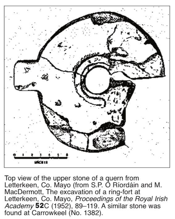
A ditch that was mainly V-shaped in profile delimited the ringfort. It averaged 2.2m deep and was 3m wide at the upper levels, tapering to 0.6m wide at the base. The upper fill was modern, probably the result of the disturbance that had occurred across the site. The lower fills provided a small assemblage of animal bone, including deer antler. The upper part of a fragmented quernstone with a stone handle protruding from the edge was found in the ditch on the eastern side of the site. Similar quernstones are known from Letterkeen, Co. Mayo, c. 15km south-west of this site, and from the Inishkea Islands, off the Mullet Peninsula. The remains of a bronze ring-pin were also found in the ditch fill.
The internal bank had been removed, probably by modern disturbance, at the north-east and east. Otherwise it was redeposited boulder clay laid down in regular layers. A hut site post-dating the construction of the bank had been cut into it at the north-west, with two opposing post-holes at the entrance.
Children’s burial-ground
Two phases of burials were uncovered in the interior of the ringfort, each in a confined area in the northern quadrant. What may be an earlier phase was represented by four oval cuts in redeposited boulder clay, each containing the skeleton of an infant aligned east–west. A pin (bronze or copper) was found with two of the skeletons. Beside the graves were further infant burials. In this case skeletons were on top of each other, with no particular order or alignment. Neonatal remains were found in very shallow cuts at the lowest levels of this phase of burials.
Shroud-pins found with these skeletons suggest a date in the 19th–20th century.
There was no local tradition of burials having taken place within the ringfort.
Enclosure
Excavation showed that the ringfort overlay an earlier ditched enclosure that continued around the perimeter of the site, directly beneath the internal bank of the ringfort, except at the east, where both features had been removed.
The ditch was U-shaped in profile and 0.4–0.8m deep. It was 1.1m wide at the upper levels, tapering to 0.3m at the base. There was no indication of an associated bank. The ditch had been cut into redeposited boulder clay that seemed to form a surface on both sides of the ditch. At the north three diagonal U-shaped cuts were seen extending from the inner and outer edges of the ditch and through the redeposited surface. There were frequent inclusions of charcoal in the fill at the base of one of the cuts. The ditched enclosure seemed to be associated with a very sterile, black, gravelly clay that had built up in the interior of the site, below the modern disturbance. This layer was above natural gravel and extended beneath the ditched enclosure but also abutted the redeposited material in the interior of the site.
A series of cylindrical pits uncovered in the north and east quadrants of the enclosure may also be associated with this phase. They had all been cut into the sterile, black, gravelly clay and in some cases were centrally placed below the oval grave-cuts. In one of the pits several sherds of coarseware pottery were found.