2002:1287 - ARDEE: Market Street, Louth
County: Louth
Site name: ARDEE: Market Street
Sites and Monuments Record No.: N/A
Licence number: 02E0193
Author: Richard Clutterbuck, Cultural Resource Development Services Ltd.
Author/Organisation Address: Unit 4, Dundrum Business Park, Dundrum, Dublin 14
Site type: Historic town
Period/Dating: Multi-period
ITM: E 696041m, N 790790m
Latitude, Longitude (decimal degrees): 53.857678, -6.540075
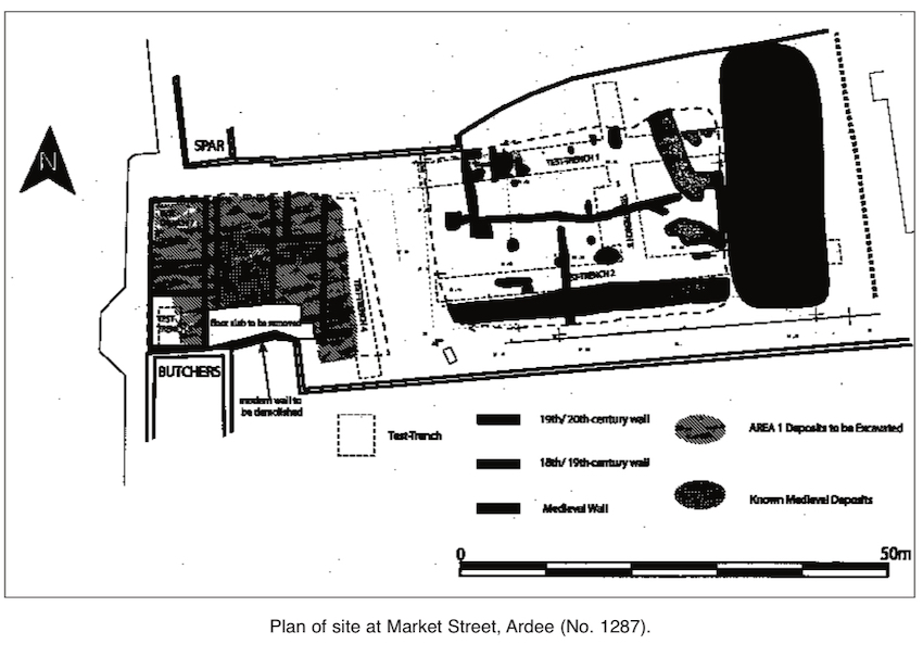
Test excavations were carried out as part of an assessment of the site of a proposed new credit-union building at Market Street, Ardee. The site consisted of two adjacent properties fronting onto Market Street and a common back garden area; a lane gives access to an Eircom property to the rear of the site. The site was divided into two areas: Area 1 consisted of the footprint of the proposed credit-union building (448m2); Area 2 was the back garden (960m2). The site was considered archaeologically significant because it is within the zone of archaeological potential identified by the Urban Archaeological Survey and the Ardee Development Plan 1997. More specifically, it was also anticipated that the site would contain significant medieval and post-medieval archaeology because of its location fronting onto Market Street and adjacent to the medieval church and graveyard of St Mary’s. The buildings on the site dated to the late 19th and 20th centuries and were not listed for preservation; they were not deemed to be of archaeological significance. These were demolished to their ground-floor level, leaving their floor slab and foundations in place.
Test excavations were carried out in August and September 2002, when seven trenches were opened: four in Area 1 and three in Area 2. They revealed that there were archaeological deposits over the entire site, with variations in the complexity of the material. A total of 53 features were identified, modern (18th–19th century) and medieval (13th–16th century); seventeen features were found for which a date could not be determined but which are potentially medieval. Deposits or pits containing butchered bone and 19th-/20th-century pottery and glass were identified in Area 2; the remains of butchered bone on the site were anticipated, as the site had been a butcher’s shop in the 20th century.
Four features were definitely dated to the medieval period from artefact association. F103, in Area 2, the back garden, was a dark brown spread of ash and stone that contained a sherd of late medieval pottery. F303 was also exposed in the back garden and consisted of a linear ditch feature running roughly east–west. It was 1.5m wide and 0.55m deep and contained a single sherd of medieval pottery; this may have been a property boundary between two medieval burgage plots. The features found in Test-trench 6 contained relatively large amounts of medieval pottery (84% of the total amount recovered during the excavations), which date the features to the medieval period (13th–15th centuries). The medieval ceramic finds from the site consist mainly of body sherds of jugs and pots, without diagnostic elements such as rims, bases or decorations. A fragment of a 14th–15th-century green-glazed, line-impressed tile was recovered from F604; the tile fragment appears to have been deliberately snipped and may be the remnants of a refurbishment of the adjacent parish church. The features suggest occupation debris or refuse, and indicate intensive occupation in the medieval period at least. F606 also contained a fragment of iron slag, which suggests industrial activity.
In November 2002 the mechanical removal of 0.28–0.74m of overburden, consisting of modern concrete floor slab and demolition rubble, took place. Where archaeologically significant deposits were exposed, they were left in situ. Fifteen definite medieval features were recorded, most in the central part of Area 1.
They consisted of a short length of clay-bonded wall (F1017), a hearth (F1013) and surrounding features. A number of other features, of undetermined date but potentially medieval, were identified. All of these features were bounded, and to a certain extent overlain, by a series of post-medieval walls and features, most of which can be correlated with structures depicted on the 19th- and early 20th-century OS maps.
Area 2, the garden area, presented a less complex collection of features than Area 1. Approximately 0.8–1m of topsoil was removed. A feature identified as medieval from associated pottery consisted of a linear ditch, probably representing the boundary between two medieval properties (F303). In addition, a number of discrete features and spreads were uncovered for which no definite date can be determined but which are potentially medieval. As in Area 1, several features in the garden correlated with those depicted on the OS maps, principally the linear features that corresponded with mapped garden boundaries, as well as part of a range of buildings depicted on the first-edition OS map (1836).
Another 23 sherds of medieval pottery were recovered from the surface of archaeological features and from disturbed contexts; as in Phase 2, most of this pottery came from the middle of Area 1.
A complete excavation of the site is to proceed in 2003.