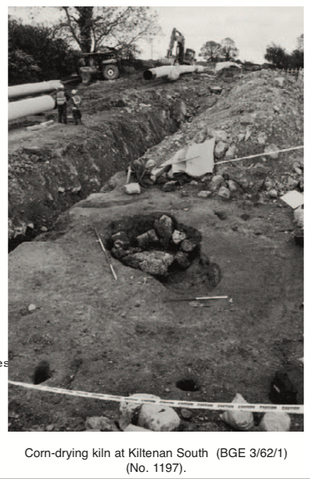
County: Limerick Site name: KILTENAN SOUTH (BGE 3/62/1)
Sites and Monuments Record No.: N/A Licence number: 02E0666
Author: Graham Hull and Tony Bartlett, Margaret Gowen & Co. Ltd.
Site type: Kiln - corn-drying and Industrial site
Period/Dating: Prehistoric (12700 BC-AD 400)
ITM: E 543171m, N 642122m
Latitude, Longitude (decimal degrees): 52.527492, -8.837496
This site was examined as part of Bord Gáis Éireann’s Pipeline to the West. A keyhole-shaped kiln, two post-holes and two linear gullies were excavated. The post-holes and gullies had no direct stratigraphic relationship to the kiln or to each other. However, given the proximity of all five features to each other, it would not be unreasonable to presume that they all represent a single phase of activity.
The kiln was 3.08m long (east–west), 1.96m wide at the eastern end and 1.2m wide at the western end, and 0.73–0.4m deep. The sides were lined with limestone slabs and sloped down quite steeply to a flattish base. The kiln had two functional elements: a stoke-hole at the western end and a firing chamber at the eastern end. The base of the firing chamber was reddened from in situ burning. Four fills were identified. The primary fill was a light orange/brown, silty clay with occasional charcoal flecking and was found only at the eastern side of the kiln, in the firing chamber; it may have been deposited to achieve the desired shape of the chamber. The secondary fill was a dark brown/black, silty clay with frequent charcoal flecking and pieces. The charcoal pieces were 0.01–0.03m in diameter. Frequent charred seeds, probably cereal, were also recorded. The tertiary fill was a mid-orange/brown silty clay with orange/pink burnt clay pieces. Frequent charcoal flecks and some charred seeds were found in the tertiary fill. A small quantity of cremated, rather than merely burnt, bone was found in this context. It is likely that the tertiary fill represent the final stoke-out of the firing chamber. The final fill of the kiln was a mid-brown silty clay with occasional charcoal flecking, 0.52m thick. Some small pieces of unburnt bone were recovered from this upper fill. Seemingly, topsoil had been used deliberately to backfill the void made by the disused kiln.
On initial cleanback of the site, it was seen that a deposit of topsoil partly masked the archaeological features. This topsoil was c. 0.05m thick in places and was not as friable and humic as that observed in the section at the unstripped fence-line. It would not be unreasonable to propose that this masking layer was, therefore, old topsoil. Three artefacts were recovered from the old topsoil. These were a barbed and tanged chert arrowhead, a piece of chert debitage and a possible sandstone hammer. These three artefacts may have derived from elsewhere as part of agricultural activity or even the topsoil-stripping associated with this project, but this seems improbable as only a few dozen pieces of worked flint and chert have been found from more than 200 sites excavated as part of the Pipeline to the West in counties Limerick and Clare. It seems unlikely that two pieces would be found randomly deposited over an unrelated archaeological feature. This said, it should be noted that a probable prehistoric settlement was excavated by Kate Taylor less than 200m west of the kiln, at Kiltenan North (No. 1198, Excavations 2002, 02E0667).
One of the post-holes was 1.8m north-west of the kiln. It was oval, measuring 0.29m north-east/south-west by 0.18m. The sides were vertical and came down to a concave base, 0.48m deep. A flint thumbnail scraper was recovered from the fill. The other post-hole, 2.3m north of the kiln, was oval and measured 0.32m north–south by 0.23m. The sides of the post-hole were vertical and came down to a concave base, 0.26m deep.
One of the linear gullies was 0.6m to the east of the kiln and was oriented north–south. The gully had been truncated by the gas-pipe trench to the north, and a 1.62m-long stretch was recorded. The gully was 0.29m wide and 0.08m deep, with a concave profile. The other linear gully was 1.6m north of the kiln and was oriented north–south, parallel to the first gully. It was 1m long, 0.2m wide and 0.08m deep. The profile and fill of both gullies were very similar and suggest that they were dug to accommodate ground-beams. The gullies were 3.5m apart.
The kiln clearly was built to dry corn. The abundant seeds in the samples taken from the kiln fill should provide species identification and a tightly focused radiocarbon date. The presence of the thumbnail scraper and the arrowhead suggests, at this stage, that a Bronze Age date would not be inappropriate. However, very few prehistoric kilns are known in the archaeological record, and most comparable features are thought to be Early Christian.
The presence of the gullies and post-holes suggests that, if they are contemporary with the kiln, they represent an external superstructure. Perhaps this structure was a windbreak, built to control the air currents in the vicinity of a flammable process. Clearly, on the final firing of the kiln this precaution failed, testified to by the burnt cereal grain. The structure described by the post-holes and gullies may, alternatively, have been used to house the treated and untreated cereal.

2 Killiney View, Albert Road Lower, Glenageary, Co. Dublin