2002:1080 - BALLINCURRA (BGE 3/77/27–9), Limerick
County: Limerick
Site name: BALLINCURRA (BGE 3/77/27–9)
Sites and Monuments Record No.: N/A
Licence number: 02E0470
Author: Kate Taylor, Margaret Gowen & Co. Ltd.
Author/Organisation Address: 2 Killiney View, Albert Road Lower, Glenageary, Co. Dublin
Site type: Fulacht fia, Pit, Ring-ditch and Cremation pit
Period/Dating: Bronze Age (2200 BC-801 BC)
ITM: E 559436m, N 634560m
Latitude, Longitude (decimal degrees): 52.460985, -8.596898
This site was examined as part of Bord Gáis Éireann’s Pipeline to the West. Several areas of archaeological interest were excavated as a single site. At the eastern end, near a small stream, was a fulacht fiadh; to the east of this, further up the slope, were two large pits and a cremation burial; farther east again were two small ring-gullies. These separate elements of the site were not stratigraphically related; however, in the absence of absolute dates, the complex is considered, on the basis of the limited artefactual evidence, to be broadly Bronze Age. Further interpretation will consider the juxtaposition of the probable domestic ring-gullies, the pits (the use of which is currently unknown), the fulacht fiadh, which is a feature usually thought of as having a utilitarian purpose, and the cremation burial.
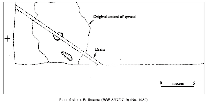
The fulacht fiadh spread was irregularly shaped, measuring 10m by 9m, and was less than 0.1m thick, with a fairly flat profile; it extended to the southern baulk and appeared to continue into the adjacent field. Two overlapping deposits were recorded, both containing fractured burnt stone and the upper including a component of charcoal. Two cut features were revealed below the spread: a concave scoop and a trough. The scoop measured 2.05m (north-west/south-east) by 0.74m and was 0.11m deep; it was filled with material identical to the upper spread deposit. The trough was subrectangular with steep sides and a flat base. It measured 1.56m by 1.16m and was 0.42m deep. It was not lined but was filled with a deposit rich in charcoal and burnt stones.
Almost 20m to the east of the fulacht fiadh two large pits lay less than 1m apart. The western one was 1.9m in diameter and 1.4m deep, with a conical profile. The pit had four fills, the primary a thin layer with a high charcoal content and the others silty clays. A possible recut was apparent in the final fill. A small crescentic flint scraper was retrieved from the single, silty clay fill of this recut. The eastern pit was subrectangular, measuring 2.62m by 1.08m. It had steep sides and a fairly flat base and was 0.56m deep. There were six fills; again, the lowest was a thin layer of charcoal-rich material lining the base and sides. One of the secondary fills was a compact deposit consisting primarily of stones, almost entirely sub-rounded pieces of weathered limestone of regular size (70mm in diameter). The remaining fills were soft, silty clays. Neither pit showed evidence of in situ burning.
A single cremation burial was excavated to the north of the pits. The cut was an irregular oval shape with a concave profile. It measured 0.36m by 0.32m and was 0.12m deep. Two fills were discernible: the upper had a large charcoal component, including pieces of charred twigs; the lower was an ashy material with little charcoal but much cremated bone, including some large pieces. Initial comparison with other cremation burials excavated during the pipeline project suggests that the presence of recognisable anatomical remains is an unusual feature. It appears that in most the cremated bone was crushed before deposition.
The two ring-gullies at the eastern end of the site lay just 1m apart. The western one was incomplete, having been truncated by a large and very modern field drain. The surviving structure was an arc of gully forming between one-third and one-half of a circle, continuing into the adjacent field to the south. The gully itself was 0.25–0.4m wide and 0.11–0.18m deep, with an irregular concave profile. A possible terminus was observed at the north-west, although a particularly shallow length at the north-east provided an alternative location for an entrance. A speculative extrapolation of the surviving arc to a full circle indicates that the original internal diameter of the gully may have been c. 3m, enclosing an area of c. 9.5m2. No evidence was observed of internal features such as post-holes. It is likely that the gully either represents a beam-slot to hold the walls of a small house or is a drip gully surrounding a structure constructed by other means. The suggested size of the feature, smaller than the typical range for round houses, seems more appropriate for a slot-trench, possibly holding timber planking. The only item recovered from the gully was a very fragmentary bone.
The eastern ring-gully differed from its neighbour in survival, form and size. It comprised a penannular gully with two post-holes, one at each terminal, and was notable for its extremely small diameter. It formed an almost perfect circle with an internal diameter of 2.34m, enclosing an area of c. 7.3m2; no internal features were present. The gully itself was on average 0.2m wide and 0.12m deep, with a rounded profile. The two post-holes measured c. 0.2m in diameter and were 0.04m and 0.1m deep. They marked an entrance that faced north-east and was 0.95m wide. Almost opposite the door the gully became shallow, being entirely absent for 0.8m, not an unusual feature for the rear parts of ring-gullies. The remains appear to represent a small hut, presumably with the gully operating as a slot-trench for timber planking. Other instances of these diminutive structures are known, for example, at Curraghatoor, Co. Tipperary (Doody 1987). Excavation produced two artefacts: a broken chert thumbnail scraper and a small piece of worked chert.
Reference
Doody, M.G. 1987 Late Bronze Age huts at Curraghtoor, Co. Tipperary. In R.M. Cleary, M.F. Hurley and E.A Twohig, Archaeological excavations on the Cork–Dublin gas pipeline (1981–82), 36–42. Cork.