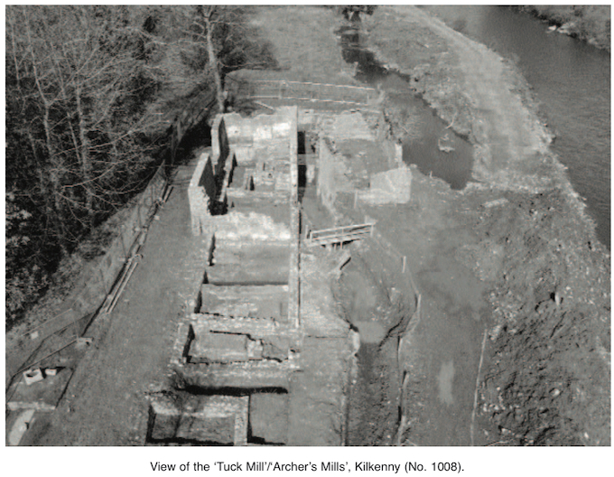
2002:1008 - KILKENNY: The ‘Tuck Mill’/‘Archer’s Mills’, Dukesmeadows (Site NOR 17), Kilkenny
County: Kilkenny
Site name: KILKENNY: The ‘Tuck Mill’/‘Archer’s Mills’, Dukesmeadows (Site NOR 17)
Sites and Monuments Record No.: N/A
Licence number: 01E1041
Author: Ian W. Doyle, for Margaret Gowen & Co. Ltd.
Author/Organisation Address: 2 Killiney View, Albert Road Lower, Glenageary, Co. Dublin
Site type: Milling complex
Period/Dating: Post Medieval (AD 1600-AD 1750)
ITM: E 651439m, N 655783m
Latitude, Longitude (decimal degrees): 52.650807, -7.239792
As part of the continuing River Nore (Kilkenny City) Drainage Scheme, the Office of Public Works proposed to remove two mill buildings referred to locally as the ‘Tuck Mill’. The two roofless stone buildings were on the right bank of the River Nore, c. 600m west of Kilkenny Castle and c. 200m west of the Ormonde Mills complex. After excavation in 2002, these buildings were removed to facilitate widening of the river.
The mill buildings comprised two dilapidated structures either side of a mill-race. The southern building (Structure A) was of masonry construction and measured c. 15.8m east–west by 7m. The walls were unstable but survived to a maximum height of 3.5m. A possible hearth was situated at the eastern gable wall, and there were modern concrete additions at the western gable wall. A smaller building (Structure B) stood on the northern side of the mill-race: a rectangular masonry structure measuring 12.8m east–west by 6.5m. The walls of this were more stable: the northern wall survived to a height of c. 3.5m, but the southern wall was more ruinous. The impressions left by sluice-gates were present on the walls either side of the mill-race. The clearance of vegetation to the east of the standing remains revealed the foundation of a demolished structure (Structure C).
In 1399 James, earl of Ormonde, granted to William Archer, carpenter, the use and profits of four mills in and near Kilkenny. These mills were to be repaired by Archer and remained in the possession of the family until the 17th century. The Down Survey of 1654–6 records three mills ‘lying half a mile from the Citty southward upon the river Neore’. Thomas Archer was the tenant when Kilkenny was taken in 1650, and all of the buildings were stone walled with roofs of thatch or partly slated. At that time two mills were for corn, and the other was a ruined tuck mill (used to finish woollen cloth). The adjacent Kilkenny Canal fed the mill-race on which the mill buildings stood. The construction of the canal began in 1757, and the project was abandoned in 1761. Although no medieval fabric was uncovered during the excavations, it is likely that the mill buildings represent Archer’s Mill, subsequently Dullard’s Mill.
Work began with the clearing of vegetation in October 2001 (Excavations 2001, No. 697) but ceased amid safety concerns because, owing to the unstable condition of the walls of both standing structures, it was not possible to excavate trenches in the interior. Limited demolition of these walls, entailing the removal of the unstable upper parts, began in January 2002. Extensive open-area excavation started thereafter and continued until April 2002.
The earliest activity on-site related to a dried-up water channel, oriented north-west/south-east, on the same alignment as the later mill buildings. An area of burning found within the natural alluvial deposits has also been assigned to this phase. It is unclear whether the water channel was related to milling on the site or was merely a natural watercourse. The next activity on the site appears to relate to the construction of a stone weir at the upstream end of the site. The weir was roughly built using irregularly coursed limestone blocks compacted into a clay core. The weir was badly truncated by later building on the site and was partly incorporated in the foundations of Structure B, obscuring its original orientation. A stratigraphic relationship between the weir and the dried-up water channel was not discovered owing to the large amount of truncation on the site, and no dates are given for either at the time of writing.
The earliest building on the site was identified by an east–west-oriented wall, which partially cut into the silted-up river channel. Two north–south-aligned walls ran off this latter wall at right angles. The walls were roughly built with limestone rubble and coarse limestone mortar. This U-shaped structure had no northern wall or floor levels associated with it, presumably owing to their removal in later phases. Although the remains of this phase were very fragmentary, the dimensions of the structure appear similar to one of the structures mentioned in the Down Survey of 1654–6.
The next phase saw a large rectangular structure constructed on the site. This building survived to 52m long and c. 0.95m high. It was situated under Structure A, on the same alignment as the east–west-running wall from the previous phase. A machine pit was also constructed in Structure A, against the northern wall, during this phase. The use of Structure B extended beyond this phase, with a single wall forming the northern side of the mill-race.
The second phase of activity seems to relate to the construction of the canal in 1756–61. The creation of the canal, which runs north-west/south-east to the south of the site, appears to coincide with the insertion of a new gable wall in Structure A, which reduced the western limit of the large rectangular buildings. An internal wall appears to have been constructed to divide the building into eastern and western halves. Two additional buildings seem to have been constructed during this phase. An eastern extension was added to Structure C, and a separate, rectangular structure, on the same alignment as Structure C but farther east, was completed. It appears that Structure B was constructed during this phase; it contained several large masonry features that were probably used as supports for machinery. A small millpond was also constructed to the west.
The next phase of activity on the site appears to relate to the reduction in size of Structure B, with the construction of a new gable wall and of an overflow channel serving the millpond in the area where Structure B had previously extended. The floor level over the entire site was raised, an overflow pit was added in Structure A, and the machine pit in Structure B was redesigned. A series of small, red-brick walls was built within Structure C during this phase, and the walls of the entire area were finished with a smooth lime plaster.
Phase 3 saw a fairly dramatic change in the design of the mill. Structure A was rebuilt during this phase as a two-storey building, which appears to have been redesigned for larger machinery. A machine pit in Structure A was backfilled with large stones and gravel, and a cobbled floor was laid within the entire building. Structures B and C appear to have largely gone out of use at this stage. This activity can be dated by cartographic evidence to between 1861 and 1869.
The fourth phase on the site saw the construction of a subterranean pump-house to the south of Structure C and the laying of a concrete floor with concrete machine pads in Structure A. The construction of the pump-house can be dated to 1884. This phase appears to coincide with a change of ownership of the mill, as represented by the name Dullard’s Mill (Bradley 2000, 6). The final use of the site was represented by the construction of concrete animal pens within Structure A and the blocking of the window opes therein. This occurred during the mid-20th century.
A smaller, rectangular structure was also excavated. This structure, c. 100m downstream, revealed a boundary wall onto which a two-phase masonry building had been constructed. A red-brick kiln or oven was uncovered at the end of the structure. This structure appears to span the 18th and 19th centuries.
Reference
Bradley, J. 2000 Kilkenny. Irish Historic Towns Atlas No. 10. Dublin.