2002:0805 - BALLYDOWNY, Killarney, Kerry
County: Kerry
Site name: BALLYDOWNY, Killarney
Sites and Monuments Record No.: N/A
Licence number: 02E0055
Author: Jacinta Kiely, Eachtra Archaeological Projects
Author/Organisation Address: 3 Canal Place, Tralee, Co. Kerry
Site type: Hearth, Metalworking site, Fulahct fia, Burnt mound, Ring-ditch and Cremation pit
Period/Dating: Multi-period
ITM: E 495022m, N 591933m
Latitude, Longitude (decimal degrees): 52.069384, -9.531230
Planning permission was granted by Kerry County Council for 118 houses at Ballydowny, Killarney. The grant of planning requested that all ground disturbance be monitored. The site is in the western suburbs of Killarney, to the north of the N72. Nine areas of archaeological stratigraphy were identified; all were fully excavated. The radiocarbon results show occupation in these areas from the Neolithic period through the Bronze Age and Iron Age and up to the early medieval period.
In Trench 1 an area measuring 8m north–south by 9m was excavated. A hearth with a linear feature at the south-west was the main feature uncovered. The hearth was oval and contained six fills, only one of which extended into the linear feature. Slag and tuyère fragments were recovered from two of the fills. The linear feature measured 3.2m by 0.9m by 0.29m deep. It contained six fills; slag was recovered from the fills at the northern end. The hearth was probably used for smithing. The slag derived from the secondary metalworking process of iron smithing. A small truncated pit, possibly a second hearth, was revealed 4m to the north-east. Slag and charcoal were recovered from one of the fills. A mix of cereal grain and arable weeds was recovered from the pit. This may be a by-product of cereal processing that became charred when it was used as tinder or fuel.
Two stake-holes were found c. 4m east of the hearth.
Trench 2 measured 5m by 5m. A burnt pit, a furnace, was found, measuring 0.65m by 1.17m by 0.18m deep. A calibrated radiocarbon date from the early medieval period (AD 1270–1390) was obtained from one of the fills of the pit. The base of a shaft furnace was recovered from the pit. Fragments of slag were recorded in some of the fills. A linear feature was situated directly north-east of the burnt pit. Both features cut a ditch, U-shaped in plan and oriented south-west/north-east. This measured 5.8m by 1.4m by 0.44m deep.
A fulacht fiadh was recorded in Trench 3. The mound measured c. 11m north–south by 4.4m. A number of agricultural features were cut into the surface of the mound, which was composed of two layers. The upper layer was a silt that included 70% heat-shattered sandstone. The lower layer was a charcoal-rich, sandy silt with 50% heat-shattered sandstone. A calibrated radiocarbon date from the Early to Middle Bronze Age (1892–1540 BC) was obtained from the lower layer. The mound covered a hearth and a trough. The trough was oval and lay directly south-east of the hearth. It was cut through the clay subsoil. The hearth was set on the ground in the southern shadow of a large boulder. Four stake-holes 2m west of the hearth may have formed a windbreak.
Two possible fulachta fiadh were recorded in Trench 4. The area was prone to flooding as surface water from the surrounding area drained and collected here. Two spreads of burnt-mound material were recorded, one 3m south of the other. The northern mound was irregular in plan and measured 5m by 5m. It was composed of two layers. Both contained 50% heat-shattered sandstone, and the lower layer included charcoal. The mound covered two troughs. Trough A was subcircular, with a diameter of c. 1.7m. A small concentration of animal bone was recovered from the fill. Trough B was 2m south of Trough A.
The southern mound was irregular in plan and measured c. 4m north–south by 5m. It was composed of a charcoal-rich silt and included heat-shattered sandstone. It overlay a trough and a pit. The trough was cut through natural gravels and underlying clay. Nine stake-holes cut the eastern end of the base of the trough.
Trench 5 was on the southern perimeter of the development site, on the edge of the Killarney–Fossa Road. The trench measured 6m by 3m. Four burnt layers were recorded. The largest was a burnt silty clay, measuring 1.4m by 1.6m. It included fragments of charcoal, slag, burnt bone and six flint end scrapers. A calibrated radiocarbon date from the Early Bronze Age (2030–1870 BC) was obtained. A concentration of 35 stake-holes was recorded in the trench. They were similar in morphology: circular, with steep sides and a rounded base. End scrapers and flint debitage were recovered from some of the stake-holes. The stake-holes may have formed a number of screens or windbreaks.
A fulacht fiadh was recorded in Trench 6, c. 50m south of Trench 4. The burnt mound measured 12m by 5m and was composed of five sandy silt layers that included 50% heat-shattered sandstone and charcoal. A trough and a hearth underlay the mound. The trough was rectangular and lay 0.8m south-east of the hearth. The hearth measured 1.6m by 1.4m. The sides had been banked up/pushed upward from the outside to contain the fire. The south-west side of the hearth was open to allow access to the trough. Three pits were excavated in the vicinity of the hearth and trough, differing in plan and size.
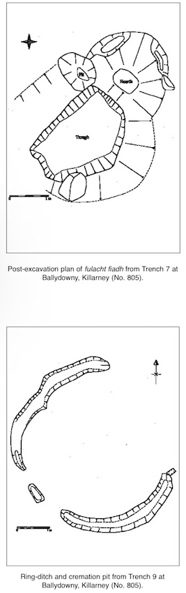
Trench 7 was in the extreme south-east corner of the site. The burnt mound found here was the smallest excavated on-site. The trough and hearth were the most elaborate. The mound was composed of one layer of silt that included 60% heat-shattered stones. It measured 5.8m by 2.2m. The trough was rectangular, measuring 2.5m by 1.8m, and was 0.55m deep. The edge of the trough was partially stone lined. A stone-lined hearth lay 0.3m east of the trough. The hearth was open on the south-west side to allow access to the trough. A calibrated radiocarbon date from the Middle Bronze Age (1490–1200 BC) was obtained from charcoal from the hearth.
An isolated pit was recorded in Trench 8, c. 25m north-east of the fulacht fiadh in Trench 6. The pit measured 2.64m by 1.04m by 0.7m deep.
Trench 9 measured 25m by 9m. A slot-trench, a hearth and a variety of stake-holes were found at the eastern end of the trench. A ring-ditch with a cremation pit was revealed at the western end of the trench. The slot-trench was oriented roughly east–west, c. 10m long, 0.3–0.5m wide and 0.08m deep. There was a gap in the centre of the trench. Eleven stake-holes were clustered in the area of the gap of the slot-trench. Two more lay west of the termination of the slot-trench. A small hearth was revealed north of the slot-trench and 8m east of the ring-ditch. It was the only feature found to the north of the slot-trench.
The external measurements of the ring-ditch were 5.5m by 4m. The ditch was 0.4–0.5m wide and 0.16–0.2m deep. The entrance was 3.5m wide and faced north-east. No features were revealed in the interior of the ring-ditch. Five fills were recorded in the ditch. The removal of the main fill revealed burnt deposits at the terminals of the ditch. The burnt deposit in the southern terminal included cremated bone. The cremation pit underlay the burnt deposit and measured 0.25m by 0.16m by 0.19m deep. The fill of the cremation pit included 50% cremated bone and 20% charcoal. A calibrated radiocarbon date from the Iron Age (400–170 BC) was obtained from the pit. Linda Fibiger, osteoarchaeologist, examined the cremated bone. The remains were those of one adult (25+ years old). Most anatomical regions were represented in the cremation. The presence of small bones suggests that the collection of bone from the pyre was thorough.